METAR & TAF KTSO
KTSO does not publish a METAR.
Showing the nearest reporting station: KPHD (HARRY CLEVER FLD) · 16.5 NM away. Conditions at KTSO may differ.
METAR · KPHD
Observed 22:53Z
KPHD 262253Z AUTO 00000KT 10SM BKN080 OVC100 22/19 A3008 RMK AO2 RAB04E16B39E49 SLP180 P0000 T02220189
- Wind
- 000° @ 0 kt
- Visibility
- 10 SM
- Temp / Dew
- 22°C / 19°C
- Altimeter
- 30.08 inHg
- Clouds
- OVC
- Density alt
- 2,084 ft
- Ceiling
- 8,000 ft AGL
- Rules
- VFR
Airport info & contacts
Manager on record, flight service, ARTCC, attendance schedule and pattern altitude — published by the FAA and refreshed every 28 days.
Location
- From city
- 1 NM SE
- VFR sectional
- DETROIT
- Pattern altitude
- 850 ft AGL · 2,014 ft MSL
- ARTCC
- ZOB · CLEVELAND
- NOTAM facility
- CLE (NOTAM-D)
Airport manager
- Name
- AL JESKE
- Phone
- 330-323-8626
- Address
- PO BOX 266, CARROLLTON OH 44615-0266
Flight service · Hours
- FSS CLE
- CLEVELAND1-800-WX-BRIEF
- Attendance
- Unattended
Frequencies
Tap any row to copy the frequency to your clipboard.
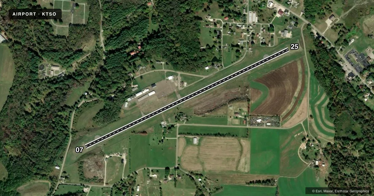
Runways & pattern
Full pagePattern entry · RWY 07
LEFT TRAFFICRunway end performance
| End | TORA | TODA | ASDA | LDA | VGSI | Approach lights | Obstruction |
|---|---|---|---|---|---|---|---|
| 07 | — | — | — | — | PAPI 2-box left | — | 15', trees, 201' from thr, 235' R of cntrln, slope 0 |
| 25 | — | — | — | — | PAPI 2-box left | — | 42', trees, 565' from thr, 217' R of cntrln, slope 8 |
Declared distances in feet. TORA = takeoff run available, TODA = takeoff distance, ASDA = accelerate-stop, LDA = landing distance.
Airport sketch
Runways drawn to scale from FAA survey coordinates, rendered over satellite imagery. Not for navigation.
Approaches & charts
Services on the field
Fuel grades, oxygen, maintenance, ramp storage and lighting — as declared to the FAA by the airport operator.
Fuel & services
- Fuel
- 100LLA
- Oxygen (bottled)
- Not available
- Oxygen (bulk)
- Not available
- Airframe repair
- Not available
- Power plant repair
- Not available
Ramp & ground
- Transient storage
- Tie-down
- Hangar
- Landing fee
- No fee published
- Customs
- Not available
- Lighting schedule
- SEE RMK
- Beacon schedule
- SS-SR
- Beacon
- White / Green (civil land)(WG)
- Wind indicator
- Yes
- Segmented circle
- No
Fuel & FBOs
Cheapest 100LL and Jet A on the field and nearby. Always confirm with the FBO before taxi.
Airport notes
Surface conditions, obstructions, local procedures, lighting outages and other notes published with each FAA cycle.
General notes
- DEER ON & INVOF ARPT.
- FOR CD CTC CLEVELAND APCH AT 216-352-2323, WHEN APCH CLSD CTC CLEVELAND ARTCC AT 440-774-0223/0490.
Lighting notes
- ACTVT REIL RWY 07 & 25; MIRL RWY 07/25 - CTAF. TWY LGTS AT TURNAROUND BUTTONS/RWY ENTRANCE.
Fuel notes
- 100LL100LL & JET A AVBL H24 VIA CREDIT CARD.
Approach & departure obstructions
- 07+12 FT FENCE, 0-200 FT DIST, 196 FT R.
- 25+7 BLDG, 34 FT DIST, 245 FT R.
- 07CTLG OBSTN EXCEEDS A 45 DEG SLP.
Other notes
- PRIOR CDN RQRD FOR TSNT HNGR.
- MANAGERRESTAURANT/FUEL ASSISTANCE 330-627-5250.
VFR map & nearby airports
VFR sectional. Tap any ICAO chip to open that airport.
Key facts · KTSO
Answer card- ICAO
- KTSO
- Name
- CARROLL COUNTY/TOLSON
- Location
- CARROLLTON, OHIO
- Elevation
- 1,163.6 ft MSL
- Traffic pattern altitude
- 2,013.6 ft MSL (850 AGL)
- Control tower
- Non-towered (use CTAF)
- Total runways
- 1
- Longest runway
- 07/25 · 4,300 ft
- Published ILS approaches
- 0
- Published frequencies
- 4
- Magnetic variation
- 7°
- Current flight rules
- VFR
- Current wind
- 000° at 0 kt
- Favored runway now
- –
Carroll County/Tolson Airport sits in Carrollton, Ohio. Field elevation is 1,163.6 ft MSL. The airport has one runway, 07/25, which is 4,300 ft long. There is no control tower. Pattern altitude is 850 ft AGL, which is 2,013.6 ft MSL. No ILS approaches are published here.
For fuel and local support, the on-field FBO is Carroll County Airport Authority. It carries 100LL and Jet A. Fuel is available 24 hours a day by credit card. The airport also notes prior coordination is required for transient hangar use. Runway lights on 07 and 25 are controlled by CTAF. Runway end identifier lights are installed on both ends. Taxiway lights are at turnaround buttons and runway entrances.
A first-time pilot should pay attention to the published obstacles near both runway ends. The Chart Supplement notes obstacles off runway 07 that exceed a 45 degree slope. It also notes a fence near the 07 end and a building near the 25 end. Deer are present on and near the airport. Clearance delivery is handled through Cleveland Approach when available. If that is closed, use Cleveland ARTCC. Check the current FAA Chart Supplement before flight for any current operational notes.