METAR & TAF 1G8
1G8 does not publish a METAR.
Showing the nearest reporting station: KPIT (PITTSBURGH INTL) · 18.1 NM away. Conditions at 1G8 may differ.
METAR · KPIT
Observed 16:51Z
KPIT 271651Z 24006KT 10SM FEW020 SCT032 BKN160 27/20 A2990 RMK AO2 SLP123 T02670200
- Wind
- 240° @ 6 kt
- Visibility
- 10 SM
- Temp / Dew
- 27°C / 20°C
- Altimeter
- 29.90 inHg
- Clouds
- BKN
- Density alt
- 2,788 ft
- Ceiling
- 16,000 ft AGL
- Rules
- VFR
Airport info & contacts
Manager on record, flight service, ARTCC, attendance schedule and pattern altitude — published by the FAA and refreshed every 28 days.
Location
- From city
- 2 NM NW
- VFR sectional
- DETROIT
- ARTCC
- ZOB · CLEVELAND
- NOTAM facility
- CLE (NOTAM-D)
Airport manager
- Name
- RICH GRANTONIC
- Phone
- 740-632-3332
- Address
- 645 MCLISTER AVE, MINGO JUNCTION OH 43938-1285
Flight service · Hours
- FSS CLE
- CLEVELAND1-800-WX-BRIEF
- Attendance
- IREG
Frequencies
Tap any row to copy the frequency to your clipboard.
Runways & pattern
Full pagePattern entry · RWY 17
LEFT TRAFFICRunway end performance
| End | TORA | TODA | ASDA | LDA | VGSI | Approach lights | Obstruction |
|---|---|---|---|---|---|---|---|
| 17 | — | — | — | — | — | — | 55', trees, 0' from thr, 100' R of cntrln, slope 0 |
| 35 | — | — | — | — | — | — | 77', trees, 35' from thr, 100' R of cntrln, slope 0 |
Declared distances in feet. TORA = takeoff run available, TODA = takeoff distance, ASDA = accelerate-stop, LDA = landing distance.
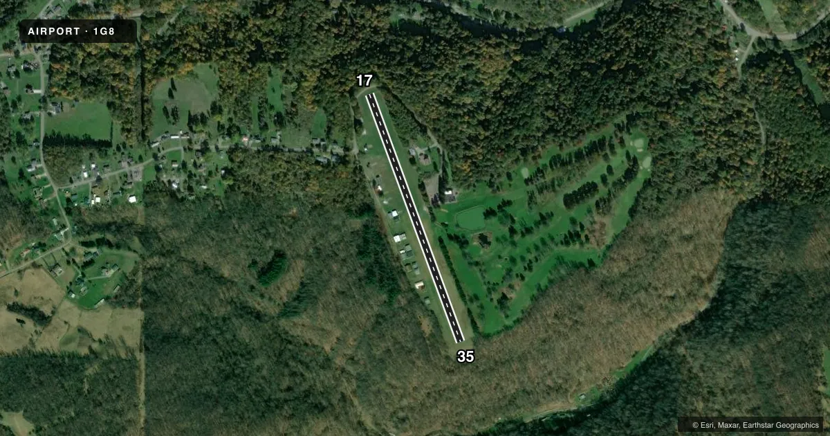
Airport sketch
Runways drawn to scale from FAA survey coordinates, rendered over satellite imagery. Not for navigation.
Approaches & charts
Services on the field
Fuel grades, oxygen, maintenance, ramp storage and lighting — as declared to the FAA by the airport operator.
Fuel & services
- Fuel
- Not available
- Oxygen (bottled)
- Not available
- Oxygen (bulk)
- Not available
- Airframe repair
- Not available
- Power plant repair
- Not available
Ramp & ground
- Transient storage
- Tie-down
- Landing fee
- No fee published
- Lighting schedule
- SEE RMK
- Wind indicator
- Yes
- Segmented circle
- No
Fuel & FBOs
Cheapest 100LL and Jet A on the field and nearby. Always confirm with the FBO before taxi.
Airport notes
Surface conditions, obstructions, local procedures, lighting outages and other notes published with each FAA cycle.
General notes
- DEER, BIRDS, & OTR WILDLIFE ON & INVOF ARPT.
- FOR CD CTC PITTSBURGH APCH AT 412-472-5591.
Lighting notes
- ACTVT NSTD LIRL RWY 16/34 - CTAF.
Runway surface & condition
- 17/35NSTD LIRL DUE TO 360 DEG GREEN LGTS AT RWY ENDS.
Approach & departure obstructions
- 17CTLG OBSTN EXCEEDS A 45 DEG SLP.
- 17ALSO +15 FT ROAD, 35 FT DIST, 90 FT L & R, 2:1 SLP; +15 FT ROAD, 55 FT DIST, ON CL, 5:1 SLP.
Other notes
- ESTABD BFR 1959.
- ROPES NOT PRVDD.
- MANAGERRICHG645@GMAIL.COM.
- MANAGERADNL CTC MIKE BAUMAN 740-512-9002.
VFR map & nearby airports
VFR sectional. Tap any ICAO chip to open that airport.
Key facts · 1G8
Answer card- ICAO
- 1G8
- Name
- EDDIE DEW MEML AIRPARK
- Location
- TORONTO, OHIO
- Elevation
- 1,067 ft MSL
- Traffic pattern altitude
- 2,067 ft MSL (1,000 AGL)
- Control tower
- Non-towered (use CTAF)
- Total runways
- 1
- Longest runway
- 17/35 · 2,268 ft
- Published ILS approaches
- 0
- Published frequencies
- 1
- Magnetic variation
- 7°
- Current flight rules
- VFR
- Current wind
- 240° at 6 kt
- Favored runway now
- RWY 17
Eddie Dew Meml Airpark is in Toronto, Ohio. The field elevation is 1,067 ft MSL. It has one runway. Runway 17/35 is 2,268 ft long and turf. The airport is not towered. CTAF is 122.9. No ILS approaches are published here.
Pattern altitude is not published. Use the standard 1,000 ft AGL for light piston operations unless the current Chart Supplement says otherwise. That puts the pattern at 2,067 ft MSL based on the listed field elevation. The runway headings are 160° and 340° magnetic. Published remarks call out nonstandard low intensity runway lights. They also note that runway 17 has nearby road and obstruction issues. Wildlife is also a factor here. Expect deer and birds in the area.
There are no on-field FBOs listed in the facts. Contact the airport operator directly before arrival if you need local support. Published remarks also give a manager contact. They say to call Pittsburgh Approach for clearance delivery. This is a small turf field with limited facilities. Plan for the runway length, the turf surface and the obstruction notes near runway 17 before you go in.