METAR & TAF 7G1
7G1 does not publish a METAR.
Showing the nearest reporting station: KPIT (PITTSBURGH INTL) · 14.3 NM away. Conditions at 7G1 may differ.
METAR · KPIT
Observed 16:51Z
KPIT 241651Z 00000KT 10SM SCT046 23/10 A3011 RMK AO2 SLP197 T02280100
- Wind
- 000° @ 0 kt
- Visibility
- 10 SM
- Temp / Dew
- 23°C / 10°C
- Altimeter
- 30.11 inHg
- Clouds
- SCT
- Density alt
- 2,245 ft
- Ceiling
- Unlimited
- Rules
- VFR
Airport info & contacts
Manager on record, flight service, ARTCC, attendance schedule and pattern altitude — published by the FAA and refreshed every 28 days.
Location
- From city
- 3 NM NE
- VFR sectional
- DETROIT
- Pattern altitude
- 775 ft AGL · 2,001 ft MSL
- ARTCC
- ZOB · CLEVELAND
- NOTAM facility
- EKN (NOTAM-D)
Airport manager
- Name
- STEVEN T. ROMAN
- Phone
- 304-387-0191
- Address
- 529 HERRON RD, NEW CUMBERLAND WV 26047
Flight service · Hours
- FSS EKN
- ELKINS703-724-42881-800-WX-BRIEF
- Attendance
- IREG
Frequencies
Tap any row to copy the frequency to your clipboard.
Runways & pattern
Full pagePattern entry · RWY 04
LEFT TRAFFIC| Runway | Heading (°M) | Length | Surface | Traffic |
|---|---|---|---|---|
| 04/22 | 28° / 208° | 2,030 ft | ASPH | Standard L |
| 01/19 | 0° / 180° | 1,200 ft | TURF | Standard L |
Runway end performance
| End | TORA | TODA | ASDA | LDA | VGSI | Approach lights | Obstruction |
|---|---|---|---|---|---|---|---|
| 04 | — | — | — | — | — | — | 65', trees, 201' from thr, 125' R of cntrln, slope 0 |
| 22 | — | — | — | — | — | — | 70', trees, 201' from thr, 75' R of cntrln, slope 0 |
| 01 | — | — | — | — | — | — | 40', trees, 0' from thr, 90' R of cntrln, slope 0 |
| 19 | — | — | — | — | — | — | 70', trees, 0' from thr, 40' R of cntrln, slope 0 |
Declared distances in feet. TORA = takeoff run available, TODA = takeoff distance, ASDA = accelerate-stop, LDA = landing distance.
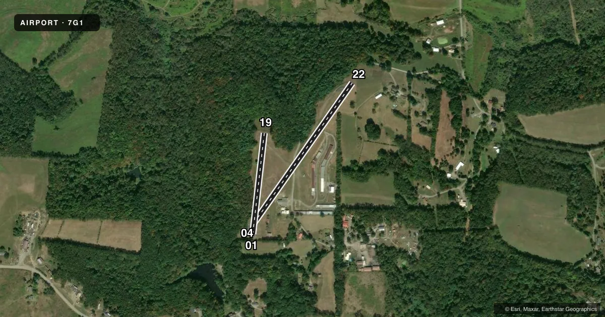
Airport sketch
Runways drawn to scale from FAA survey coordinates, rendered over satellite imagery. Not for navigation.
Approaches & charts
Services on the field
Fuel grades, oxygen, maintenance, ramp storage and lighting — as declared to the FAA by the airport operator.
Fuel & services
- Fuel
- Not available
- Oxygen (bottled)
- Not available
- Oxygen (bulk)
- Not available
- Airframe repair
- Not available
- Power plant repair
- Not available
Ramp & ground
- Transient storage
- Tie-down
- Hangar
- Landing fee
- No fee published
- Lighting schedule
- SEE RMK
- Beacon schedule
- SEE RMK
- Beacon
- White / Green (civil land)(WG)
- Wind indicator
- Yes
- Segmented circle
- No
Fuel & FBOs
Cheapest 100LL and Jet A on the field and nearby. Always confirm with the FBO before taxi.
Airport notes
Surface conditions, obstructions, local procedures, lighting outages and other notes published with each FAA cycle.
General notes
- PUBLIC ROAD CROSSES CENTER OF AIRFIELD; DO NOT TAXI ON ROAD, WING WILL NOT CLEAR STOP SIGN ON RD.
- RWY 04 & 22 NO LINE OF SIGHT BTN RWY ENDS. TFC ON RD. CROSSING RWY NOT VISIBLE FM RWY 4 END.
- RWY 04/22 SLOPES UP FM E TO W, APRX 30 FT.
- DEER ON AND INVOF ARPT.
- ULTRALIGHT ACTIVITY.
- 30 FT DROP-OFF AT EACH RWY END.
- RWY 04/22 NUMBERS ONLY.
- FOR CD CTC PITTSBURGH APCH AT 412-472-5591
Lighting notes
- DUSK-2300, OTR TIMES ON REQ.
- DUSK-2300. ACTVT LIRL RWY 04/22 123.0 - 5 TIMES ON / 5 TIMES OFF.
Runway surface & condition
- 04/22LGTS ON SE SIDE ONLY.
Approach & departure obstructions
- 0440 FT TREES 0-201 FT FM THR 60 FT LEFT.
- 2250 FT TREES 0 FT DSTC 75 FT RIGHT.
- 01CTLNG OBSTN EXCEEDS A 45 DEG SLP.
- 04CNTLNG OBSTN EXCEEDS A 45 DEG SLP.
Other notes
- REPAIRS BY PRIOR ARRANGEMENT.
- ESTABLISHED PRIOR TO 1959.
- OVERNIGHT FEE WAIVED WITH MIN FUEL PURCHASE.
- OWNERBILL JOHNSTON WWJOHNSTON55@GMAIL.COM
VFR map & nearby airports
VFR sectional. Tap any ICAO chip to open that airport.
Key facts · 7G1
Answer card- ICAO
- 7G1
- Name
- HERRON
- Location
- NEW CUMBERLAND, WEST VIRGINIA
- Elevation
- 1,226 ft MSL
- Traffic pattern altitude
- 2,001 ft MSL (775 AGL)
- Control tower
- Non-towered (use CTAF)
- Total runways
- 2
- Longest runway
- 04/22 · 2,030 ft
- Published ILS approaches
- 0
- Published frequencies
- 1
- Magnetic variation
- 7°
- Current flight rules
- VFR
- Current wind
- 000° at 0 kt
- Favored runway now
- –
Herron Airport (7G1) sits near New Cumberland, West Virginia. Field elevation is 1,226 ft MSL. The airport has two runways. The longest is runway 04/22 at 2,030 ft. Runway 01/19 is 1,200 ft turf. There is no control tower. CTAF is 122.9.
No ILS approaches are published here. Pattern altitude is 775 ft AGL, which is 2,001 ft MSL. That matters here because the field is not flat. Runway 04/22 slopes up from east to west about 30 ft. Runway 04 and 22 also have no line of sight between the ends. Traffic on the road crossing the runway is not visible from the runway 4 end. Deer are reported on and near the airport. Ultralight activity also occurs here.
Lighting on runway 04/22 is on the southeast side only. The beacon runs from dusk to 2300 hours. Other times are on request. Low-intensity runway lights on 04/22 are activated by keying 123.0 five times on, then five times off. For clearance delivery, contact Pittsburgh Approach at 412-472-5591. No on-field FBOs are listed. Check with the airport operator or the FBO directly by phone before arrival for current services.