METAR & TAF KHLG
Current METAR
Observed 12:53Z
KHLG 271253Z 26004KT 8SM CLR 20/19 A2994 RMK AO2 SLP133 T02000194
- Wind
- 260° @ 4 kt
- Visibility
- 8 SM
- Temp / Dew
- 20°C / 19°C
- Altimeter
- 29.94 inHg
- Clouds
- CLR
- Density alt
- 2,056 ft
- Ceiling
- Unlimited
- Rules
- VFR
Airport info & contacts
Manager on record, flight service, ARTCC, attendance schedule and pattern altitude — published by the FAA and refreshed every 28 days.
Location
- From city
- 8 NM NE
- VFR sectional
- CINCINNATI
- ARTCC
- ZOB · CLEVELAND
- NOTAM facility
- HLG (NOTAM-D)
Airport manager
- Name
- RUSSEL W. ESCUE
- Phone
- 304-234-3865
- Address
- 115 SKYWAY LANE, WHEELING WV 26003
Flight service · Hours
- FSS EKN
- ELKINS703-724-42881-800-WX-BRIEF
- Attendance
- MON-FRI · 0700-2200
- SAT-SUN · 0800-2000
Frequencies
Tap any row to copy the frequency to your clipboard.
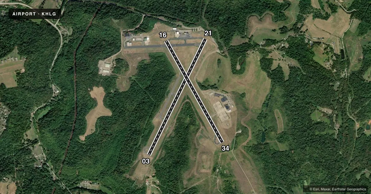
Runways & pattern
Full pagePattern entry · RWY 21
LEFT TRAFFIC| Runway | Heading (°M) | Length | Surface | Traffic |
|---|---|---|---|---|
| 03/21Favored | 19° / 199° | 5,002 ft | ASPH | Standard L |
| 16/34 | 144° / 324° | 4,499 ft | ASPH | Standard L |
Runway end performance
| End | TORA | TODA | ASDA | LDA | VGSI | Approach lights | Obstruction |
|---|---|---|---|---|---|---|---|
| 03 | — | — | — | — | — | MALSF | 26', trees, 216' from thr, 488' R of cntrln, slope 0 |
| 21 | — | — | — | — | VASI 2-box left(3°) | — | — |
| 34 | — | — | — | — | PAPI 4-box left(3°) | — | 17', trees, 468' from thr, 240' R of cntrln, slope 15 |
Declared distances in feet. TORA = takeoff run available, TODA = takeoff distance, ASDA = accelerate-stop, LDA = landing distance.
Airport sketch
Runways drawn to scale from FAA survey coordinates, rendered over satellite imagery. Not for navigation.
Approaches & charts
ILS · 1
Services on the field
Fuel grades, oxygen, maintenance, ramp storage and lighting — as declared to the FAA by the airport operator.
Fuel & services
- Fuel
- 100LLA+
Ramp & ground
- Transient storage
- Tie-down
- Hangar
- Customs
- Not available
- Lighting schedule
- SEE RMK
- Beacon schedule
- SS-SR
- Beacon
- White / Green (civil land)(WG)
- Wind indicator
- Lighted
- Segmented circle
- No
Fuel & FBOs
Cheapest 100LL and Jet A on the field and nearby. Always confirm with the FBO before taxi.
Airport notes
Surface conditions, obstructions, local procedures, lighting outages and other notes published with each FAA cycle.
General notes
- BIRDS AND DEER ON AND INVOF ARPT.
Lighting notes
- WHEN ATCT CLSD ACTVT MALSF RWY 03; REIL RWY 21 & 34; PAPI RWY 34; HIRL RWY 03/21; MIRL RWY 16/34; TWY LGTS EXCP TWY A - CTAF.
Approach & departure obstructions
- 0315 FT BRUSH, 0-199 FT DSTC, 370 FT L, 260 FT R.
- 2110 FT BLDG 150 FT DSTC, 250 FT R; 6 FT FENCE, 0-200 FT DSTC, 0-500 FT L/F; 28 FT TREE, 138 FT DSTC, 408 FT L.
- 34REIL OTS INDFLY.
- 21UNUSBL BYD 8 DEGS LEFT OF CNTRLN.
- 34PAPI OTS INDEFLY.
- 03CTLNG OBSTN EXCEEDS A 45 DEG SLP.
VFR map & nearby airports
VFR sectional. Tap any ICAO chip to open that airport.
Key facts · KHLG
Answer card- ICAO
- KHLG
- Name
- WHEELING OHIO COUNTY
- Location
- WHEELING, WEST VIRGINIA
- Elevation
- 1,194.3 ft MSL
- Traffic pattern altitude
- 2,194.3 ft MSL (1,000 AGL)
- Control tower
- Towered · 0700-2200 MON-FRI; 1000-2000 SAT-SUN
- Total runways
- 2
- Longest runway
- 03/21 · 5,002 ft
- Published ILS approaches
- 1
- Published frequencies
- 12
- Magnetic variation
- 7°
- Current flight rules
- VFR
- Current wind
- 260° at 4 kt
- Favored runway now
- RWY 21
Wheeling Ohio County Airport is in Wheeling, West Virginia. The field elevation is 1,194.3 ft MSL. It has two asphalt runways. The longest is runway 03/21 at 5,002 ft. The airport is towered. Tower hours are 0700-2200 Monday through Friday. Weekend hours are 1000-2000 Saturday and Sunday.
Runway 03 has the published ILS approach. Pattern altitude is not published in the facts, so use the standard 1,000 ft AGL for light piston aircraft unless the current FAA Chart Supplement says otherwise. The field sits near Pittsburgh Class B airspace. Verify your routing and clearances before arrival. The airport also has published notes that matter on arrival. Birds and deer are reported on and near the field. Near runway 03 there is brush close to the threshold area. Near runway 21 there are obstructions close in, including a building, a fence and a tree. Runway 34 has a PAPI listed as out of service indefinitely. Runway 34 REILs are also out of service indefinitely.
Wheeling Ohio County Airport has one on-field FBO. Wheeling Ohio County Airport carries 100LL and Jet A Prist. Call the FBO directly at (304) 277-3499 for current service details. When the tower is closed, published lighting procedures apply for the runway and taxiway lights. If you are new to the field, brief the runway 03 and 21 ends carefully. The published obstructions and wildlife make a normal stabilized approach even more important.