METAR & TAF KAFJ
Current METAR
Observed 17:07Z
KAFJ 271707Z AUTO VRB06KT 10SM FEW025 SCT037 27/22 A2994 RMK AO2 $
- Wind
- VAR @ 6 kt
- Visibility
- 10 SM
- Temp / Dew
- 27°C / 22°C
- Altimeter
- 29.94 inHg
- Clouds
- SCT
- Density alt
- 2,883 ft
- Ceiling
- Unlimited
- Rules
- VFR
Airport info & contacts
Manager on record, flight service, ARTCC, attendance schedule and pattern altitude — published by the FAA and refreshed every 28 days.
Location
- From city
- 3 NM SW
- VFR sectional
- DETROIT
- ARTCC
- ZOB · CLEVELAND
- NOTAM facility
- AFJ (NOTAM-D)
Airport manager
- Name
- DANIEL SECRIST
- Phone
- 724-228-5151
- Address
- 600 AIRPORT RD,, WASHINGTON PA 15301
Flight service · Hours
- FSS AOO
- ALTOONA1-800-WX-BRIEF
- Attendance
- MON-FRI · 0700-1900
- SAT-SUN · 0700-1700
Frequencies
Tap any row to copy the frequency to your clipboard.
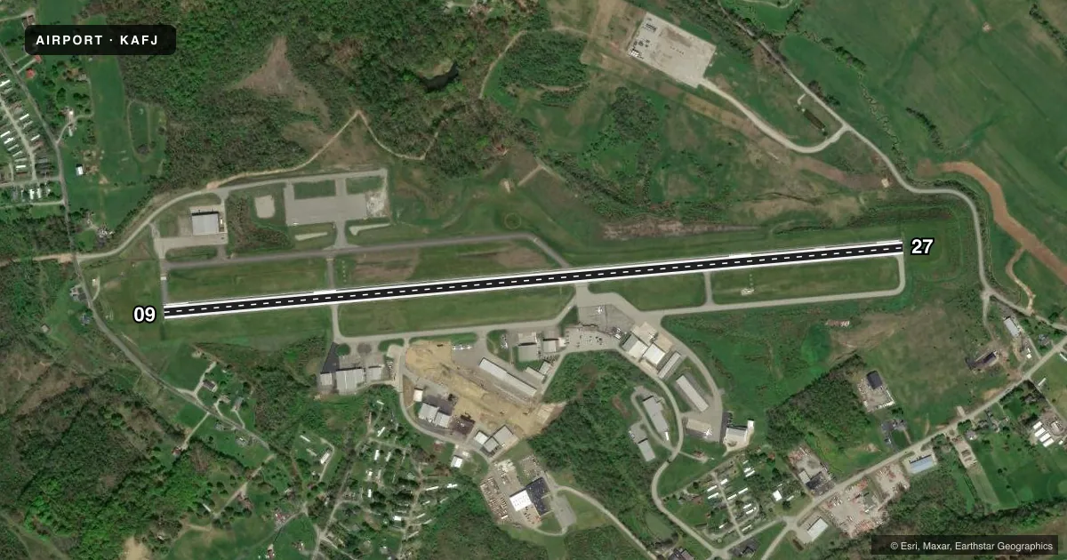
Runways & pattern
Full pagePattern entry · RWY 09
LEFT TRAFFICRunway end performance
| End | TORA | TODA | ASDA | LDA | VGSI | Approach lights | Obstruction |
|---|---|---|---|---|---|---|---|
| 09 | — | — | — | — | PAPI 4-box left(3.71°) | — | 84', trees, 369' from thr, 466' R of cntrln, slope 2 |
| 27 | — | — | — | — | PAPI 4-box left(3.09°) | — | 46', trees, 1134' from thr, 435' R of cntrln, slope 20 |
Declared distances in feet. TORA = takeoff run available, TODA = takeoff distance, ASDA = accelerate-stop, LDA = landing distance.
Airport sketch
Runways drawn to scale from FAA survey coordinates, rendered over satellite imagery. Not for navigation.
Approaches & charts
ILS · 1
Services on the field
Fuel grades, oxygen, maintenance, ramp storage and lighting — as declared to the FAA by the airport operator.
Fuel & services
- Fuel
- 100LLAA+
- Oxygen (bottled)
- High pressure
- Oxygen (bulk)
- High pressure
- Airframe repair
- Major
- Power plant repair
- Major
- Other services
- AMB,AVNCS,CARGO,CHTR,INSTR,SALES
Ramp & ground
- Transient storage
- Tie-down
- Hangar
- Landing fee
- No fee published
- Customs
- Not available
- Lighting schedule
- SEE RMK
- Beacon schedule
- SS-SR
- Beacon
- White / Green (civil land)(WG)
- Wind indicator
- Lighted
- Segmented circle
- Yes
Fuel & FBOs
Cheapest 100LL and Jet A on the field and nearby. Always confirm with the FBO before taxi.
Airport notes
Surface conditions, obstructions, local procedures, lighting outages and other notes published with each FAA cycle.
General notes
- BIRDS ON & INVOF RWY.
- 208 FT HILL & TREES 2937 FT FM THR RWY END 09. 226 FT HILL & TREES 2941 FT FM THR RWY END 09.
- 288 FT HILL & TREES 7238 FT FM THR RWY END 27. 268 FT HILL & TREES 8091 FT FM THR RWY END 27.
- 158 FT OBSTR LIT POLE APPROX 3389 FT FM THR RWY END 09. 159 FT OBSTN LIT POLE APPROX 3055 FT FM THR RWY END 09.
Lighting notes
- ACTVT REIL RWY 27; HIRL RWY 09/27 - CTAF.
Approach & departure obstructions
- 09RWY 09 PAPI UNUSBL BYD 7.0 DEGS RIGHT OF CNTRLN.
Other notes
- THIS AIRPORT HAS BEEN SURVEYED BY THE NATIONAL GEODETIC SURVEY.
- IN OPERATION PRIOR TO 1959.
VFR map & nearby airports
VFR sectional. Tap any ICAO chip to open that airport.
Key facts · KAFJ
Answer card- ICAO
- KAFJ
- Name
- WASHINGTON COUNTY
- Location
- WASHINGTON, PENNSYLVANIA
- Elevation
- 1,183.9 ft MSL
- Traffic pattern altitude
- 2,183.9 ft MSL (1,000 AGL)
- Control tower
- Non-towered (use CTAF)
- Total runways
- 1
- Longest runway
- 09/27 · 5,004 ft
- Published ILS approaches
- 1
- Published frequencies
- 7
- Magnetic variation
- 8°
- Current flight rules
- VFR
- Current wind
- 000° at 6 kt
- Favored runway now
- RWY 09
Washington County Airport sits in Washington, Pennsylvania. Field elevation is 1,183.9 ft MSL. The airport has one runway, 09/27, at 5,004 ft asphalt. There is no control tower. The published ILS serves Runway 27. Pattern altitude is not published, so use the standard 1,000 ft AGL for light piston traffic unless the current Chart Supplement says otherwise.
Skyward Aviation is on the field. It carries 100LL, Jet A and Jet A Prist. Call (724) 754-8161 for current service details before you go. The field has been surveyed by the National Geodetic Survey. Runway 27 has end identifier lights. The runway lights are high intensity and are controlled by CTAF.
This is a field to brief carefully on arrival. Published remarks show lit poles near the approach to Runway 09. Hills and trees also sit near both ends. Birds are present on and near the runway. Runway 09 has a PAPI note that limits its use beyond 7 degrees right of centerline. The airport has been in operation since before 1959. Check the current FAA Chart Supplement for any noise or operational notes before you fly in. Also verify current airspace and approach details on the chart, since this field sits near Pittsburgh frequencies.