METAR & TAF 22D
22D does not publish a METAR.
Showing the nearest reporting station: KAFJ (WASHINGTON COUNTY) · 8.9 NM away. Conditions at 22D may differ.
METAR · KAFJ
Observed 17:07Z
KAFJ 271707Z AUTO VRB06KT 10SM FEW025 SCT037 27/22 A2994 RMK AO2 $
- Wind
- VAR @ 6 kt
- Visibility
- 10 SM
- Temp / Dew
- 27°C / 22°C
- Altimeter
- 29.94 inHg
- Clouds
- SCT
- Density alt
- 2,916 ft
- Ceiling
- Unlimited
- Rules
- VFR
Airport info & contacts
Manager on record, flight service, ARTCC, attendance schedule and pattern altitude — published by the FAA and refreshed every 28 days.
Location
- From city
- 3 NM SE
- VFR sectional
- DETROIT
- ARTCC
- ZOB · CLEVELAND
- NOTAM facility
- AOO (NOTAM-D)
Airport manager
- Name
- BRUCE BANDEL
- Phone
- 412-877-4584
- Address
- 284 SHIPE RUN RD, WASHINGTON PA 15301
Flight service · Hours
- FSS AOO
- ALTOONA1-800-WX-BRIEF
- Attendance
- IREG
Frequencies
Tap any row to copy the frequency to your clipboard.
Runways & pattern
Full pagePattern entry · RWY 01
LEFT TRAFFICRunway end performance
| End | TORA | TODA | ASDA | LDA | VGSI | Approach lights | Obstruction |
|---|---|---|---|---|---|---|---|
| 01 | — | — | — | — | — | — | 143', hill, 2693' from thr, 153' R of cntrln, slope 18 |
| 19 | — | — | — | — | — | — | 67', trees, 18' from thr, 88' R of cntrln, slope 0 |
Declared distances in feet. TORA = takeoff run available, TODA = takeoff distance, ASDA = accelerate-stop, LDA = landing distance.
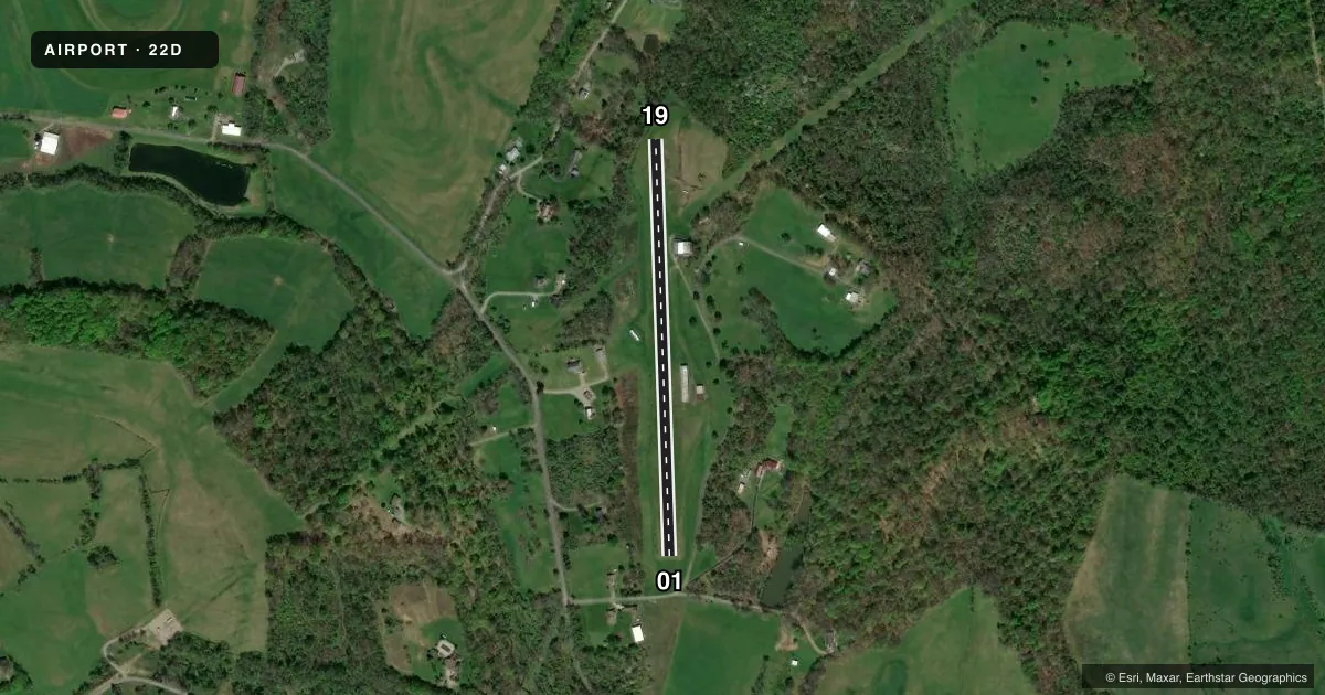
Airport sketch
Runways drawn to scale from FAA survey coordinates, rendered over satellite imagery. Not for navigation.
Approaches & charts
Services on the field
Fuel grades, oxygen, maintenance, ramp storage and lighting — as declared to the FAA by the airport operator.
Fuel & services
- Fuel
- Not available
- Oxygen (bottled)
- Not available
- Oxygen (bulk)
- Not available
- Airframe repair
- Not available
- Power plant repair
- Not available
Ramp & ground
- Transient storage
- Not published
- Landing fee
- No fee published
- Customs
- Not available
- Wind indicator
- Yes
- Segmented circle
- No
Fuel & FBOs
Cheapest 100LL and Jet A on the field and nearby. Always confirm with the FBO before taxi.
Airport notes
Surface conditions, obstructions, local procedures, lighting outages and other notes published with each FAA cycle.
General notes
- PAEW ADJ RWY 01/19 INDEFLY.
- 250 FT HIGH TERRAIN 3450 FT NORTH OF RWY 19.
- RWY NOT MAINTAINED DURG WINTER MONTHS.
- FOR CD CTC PITTSBURGH APCH AT 412-472-5591.
Approach & departure obstructions
- 1960 FT TREE: 49 FT FM RWY END 116 FT RIGHT.
- 01150 FT DTHR MKD WITH FLUSH ORANGE BUCKET LIDS.
- 191330 FT DTHR MKD WITH FLUSH ORANGE BUCKET LIDS.
- 01MARKED WITH FLUSH WHITE BUCKET LIDS BOUNDARY MARKERS.
- 19MARKED WITH FLUSH WHITE BUCKET LIDS BOUNDARY MARKERS.
- 19APCH SLOPE 20:1 TO DTHR RWY 19.
- 1966 FT TREES; 18 FT FM THLD, 88 FT RIGHT OF CNTRLN.
Other notes
- VFR OPNS ONLY.
VFR map & nearby airports
VFR sectional. Tap any ICAO chip to open that airport.
Key facts · 22D
Answer card- ICAO
- 22D
- Name
- BANDEL
- Location
- EIGHTY FOUR, PENNSYLVANIA
- Elevation
- 1,210 ft MSL
- Traffic pattern altitude
- 2,210 ft MSL (1,000 AGL)
- Control tower
- Non-towered (use CTAF)
- Total runways
- 1
- Longest runway
- 01/19 · 2,260 ft
- Published ILS approaches
- 0
- Published frequencies
- 1
- Magnetic variation
- 7°
- Current flight rules
- VFR
- Current wind
- 000° at 6 kt
- Favored runway now
- RWY 01
BANDEL (22D) is in Eighty Four, Pennsylvania. The field elevation is 1,210 ft MSL. It has one runway. Runway 01/19 is 2,260 ft long and surfaced turf-dirt. There is no control tower. CTAF is 122.9. No ILS approaches are published here.
Pattern altitude is not published, so use the standard 1,000 ft AGL for light piston operations unless the current Chart Supplement says otherwise. That puts the pattern at about 2,210 ft MSL based on the field elevation. The airport is VFR only. Published remarks also call out displaced thresholds on both ends. Runway 01 has a 150 ft displaced threshold. Runway 19 has a 1,330 ft displaced threshold. Runway 19 also has trees close to the threshold and a 20:1 approach slope to the displaced threshold. There is 250 ft terrain about 3,450 ft north of runway 19. The runway is not maintained during winter months. For clearance delivery, contact Pittsburgh Approach at 412-472-5591. If you are new to the field, plan for a short turf-dirt runway. Expect a high-elevation feel. Give the displaced thresholds a careful look before you commit to landing.