METAR & TAF G05
G05 does not publish a METAR.
Showing the nearest reporting station: KAGC (ALLEGHENY COUNTY) · 7.5 NM away. Conditions at G05 may differ.
METAR · KAGC
Observed 17:53Z
KAGC 271753Z 26007KT 220V290 10SM BKN020 BKN049 28/19 A2988 RMK AO2 SLP111 T02780189 10283 20200 58013
- Wind
- 260° @ 7 kt
- Visibility
- 10 SM
- Temp / Dew
- 28°C / 19°C
- Altimeter
- 29.88 inHg
- Clouds
- BKN
- Density alt
- 3,142 ft
- Ceiling
- 2,000 ft AGL
- Rules
- MVFR
Airport info & contacts
Manager on record, flight service, ARTCC, attendance schedule and pattern altitude — published by the FAA and refreshed every 28 days.
Location
- From city
- 1 NM SW
- VFR sectional
- DETROIT
- ARTCC
- ZOB · CLEVELAND
- NOTAM facility
- AOO (NOTAM-D)
Airport manager
- Name
- BOB USNICK
- Phone
- (412) 580-8932
- Address
- PO BOX 231, FINLEYVILLE PA 15332
Flight service · Hours
- FSS AOO
- ALTOONA1-800-WX-BRIEF
- Attendance
- IREG
Frequencies
Tap any row to copy the frequency to your clipboard.
Runways & pattern
Full pagePattern entry · RWY 32
LEFT TRAFFICRunway end performance
| End | TORA | TODA | ASDA | LDA | VGSI | Approach lights | Obstruction |
|---|---|---|---|---|---|---|---|
| 32 | — | — | — | — | — | — | 31', other, 743' from thr, 38' R of cntrln, slope 17 |
Declared distances in feet. TORA = takeoff run available, TODA = takeoff distance, ASDA = accelerate-stop, LDA = landing distance.
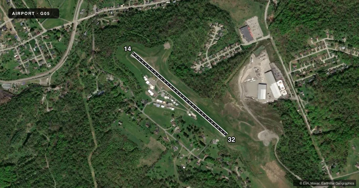
Airport sketch
Runways drawn to scale from FAA survey coordinates, rendered over satellite imagery. Not for navigation.
Approaches & charts
Services on the field
Fuel grades, oxygen, maintenance, ramp storage and lighting — as declared to the FAA by the airport operator.
Fuel & services
- Fuel
- 100LL
- Oxygen (bottled)
- Not available
- Oxygen (bulk)
- Not available
- Airframe repair
- Major
- Power plant repair
- Major
- Other services
- RNTL
Ramp & ground
- Transient storage
- Tie-down
- Hangar
- Landing fee
- No fee published
- Customs
- Not available
- Lighting schedule
- SEE RMK
- Beacon schedule
- SEE RMK
- Beacon
- White / Green (civil land)(WG)
- Wind indicator
- Lighted
- Segmented circle
- No
Fuel & FBOs
Cheapest 100LL and Jet A on the field and nearby. Always confirm with the FBO before taxi.
Airport notes
Surface conditions, obstructions, local procedures, lighting outages and other notes published with each FAA cycle.
General notes
- TRRN FALLS OFF RAPIDLY OFF AER 14; TRRN RISES OFF AER 32.
- TRANSIENT PILOTS ADVISED TO CHECK RY COND PRIOR TO USE DURG WINTER MONTHS.
- DEER ON & INVOF RY.
- ULTRALIGHTS AVOID OVERFLYING HOUSES NORTHEAST OF ARPT.
- HEL FOLLOW FIXED WING TFC PAT.
- NO ACFT PRKG ON SE PORTION OF PARL TWY NEXT TO HANGARS 16, 17 & 18.
- LMTD SIGHT DIST DOWN RWY DUE TO HUMP NEAR APP END RWY 14.
- FOR CD CTC PITTSBURGH APCH AT 412-472-5591
- PARTIAL PARL TWY MKD WITH REFLECTORS.
- RWY 14/32 ENDS NOT MUTUALLY VSB.
Lighting notes
- DUSK - AFT 0000 ACTVT ROTG BCN - CTAF
- ACTVT LIRL - CTAF.
Approach & departure obstructions
- 14RWY 14/32 ULTRALIGHTS FLY R TFC.
- 14CONTROLLING OBSTN GAS WELL 31 FT HIGH.
Other notes
- VFR OPS ONLY
- TPA ULTRALIGHTS 500 FT AGL.
VFR map & nearby airports
VFR sectional. Tap any ICAO chip to open that airport.
Key facts · G05
Answer card- ICAO
- G05
- Name
- FINLEYVILLE AIRPARK
- Location
- FINLEYVILLE, PENNSYLVANIA
- Elevation
- 1,236 ft MSL
- Traffic pattern altitude
- 2,236 ft MSL (1,000 AGL)
- Control tower
- Non-towered (use CTAF)
- Total runways
- 1
- Longest runway
- 14/32 · 2,497 ft
- Published ILS approaches
- 0
- Published frequencies
- 6
- Magnetic variation
- 7°
- Current flight rules
- MVFR
- Current wind
- 260° at 7 kt
- Favored runway now
- RWY 32
Finleyville Airpark sits in Finleyville, Pennsylvania. The field elevation is 1,236 ft MSL. It has one runway, 14/32, which is 2,497 ft long and asphalt. There is no control tower. No ILS approaches are published. The pattern altitude is not published, so use the standard 1,000 ft AGL for light piston traffic unless the current Chart Supplement says otherwise.
The on-field FBO is Finleyville Airpark. It carries 100LL. Call ahead at (724) 348-7202 if you need current field details before arrival. This is a VFR-only airport. That matters here because the published remarks point to Pittsburgh Approach for clearance delivery and list Class B frequencies in the area. Check the current chart before you go if you are crossing nearby controlled airspace.
A few runway notes matter on first visit. Runway 14/32 ends are not mutually visible. There is a hump near the approach end of Runway 14 that limits sight distance. Terrain falls off fast off the approach end of Runway 14. Terrain rises off the approach end of Runway 32. The airport also notes a gas well near Runway 14 as the controlling obstruction. In winter, check runway condition before use. From dusk until after midnight, the beacon is on and CTAF is in use.