METAR & TAF 5G8
5G8 does not publish a METAR.
Showing the nearest reporting station: KLBE (ARNOLD PALMER RGNL) · 11.0 NM away. Conditions at 5G8 may differ.
METAR · KLBE
Observed 10:35Z
KLBE 271035Z AUTO 20004KT 7SM OVC010 19/19 A2992 RMK AO2
- Wind
- 200° @ 4 kt
- Visibility
- 7 SM
- Temp / Dew
- 19°C / 19°C
- Altimeter
- 29.92 inHg
- Clouds
- OVC
- Density alt
- 1,953 ft
- Ceiling
- 1,000 ft AGL
- Rules
- MVFR
Airport info & contacts
Manager on record, flight service, ARTCC, attendance schedule and pattern altitude — published by the FAA and refreshed every 28 days.
Location
- From city
- 3 NM N
- VFR sectional
- DETROIT
- ARTCC
- ZOB · CLEVELAND
- NOTAM facility
- AOO (NOTAM-D)
Airport manager
- Name
- RICHARD H KING
- Phone
- 724-744-2900
- Address
- 1200 AIRPORT ROAD, JEANNETTE PA 15644
Flight service · Hours
- FSS AOO
- ALTOONA1-800-WX-BRIEF
- Attendance
- MON-FRI · IRREG
Frequencies
Tap any row to copy the frequency to your clipboard.
Runways & pattern
Full pagePattern entry · RWY 20
LEFT TRAFFICRunway end performance
| End | TORA | TODA | ASDA | LDA | VGSI | Approach lights | Obstruction |
|---|---|---|---|---|---|---|---|
| 02 | — | — | — | — | — | — | 245', hill, 4697' from thr, 228' R of cntrln, slope 18 |
Declared distances in feet. TORA = takeoff run available, TODA = takeoff distance, ASDA = accelerate-stop, LDA = landing distance.
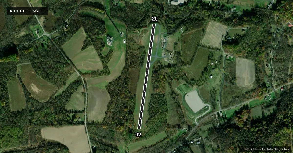
Airport sketch
Runways drawn to scale from FAA survey coordinates, rendered over satellite imagery. Not for navigation.
Approaches & charts
Services on the field
Fuel grades, oxygen, maintenance, ramp storage and lighting — as declared to the FAA by the airport operator.
Fuel & services
- Fuel
- Not available
- Oxygen (bottled)
- Not available
- Oxygen (bulk)
- Not available
- Airframe repair
- Not available
- Power plant repair
- Not available
Ramp & ground
- Transient storage
- Tie-down
- Landing fee
- No fee published
- Customs
- Not available
- Lighting schedule
- SEE RMK
- Beacon schedule
- SEE RMK
- Beacon
- White / Green (civil land)(WG)
- Wind indicator
- Lighted
- Segmented circle
- Yes
Fuel & FBOs
Cheapest 100LL and Jet A on the field and nearby. Always confirm with the FBO before taxi.
Airport notes
Surface conditions, obstructions, local procedures, lighting outages and other notes published with each FAA cycle.
General notes
- TRRN DROPS OFF RAPIDLY ON BOTH ENDS OF RWY.
- DEER & BIRDS ON & INVOF ARPT WITH OCCASIONAL RWY INCURSIONS.
- 240 FT HILL/TREES 4690 FT S OF RWY 02.
- FOR CD CTC PITTSBURGH APCH AT 412-472-5591.
- RWY 02 OPEN FOR TKOF & LNDG SR-SS; CLSD FOR LNDG SS-SR.
Lighting notes
- ARPT BCN OPRS DUSK TO 0100 LCL.
- ACTVT MIRL RWY 02/20 - CTAF.
Runway surface & condition
- 02/20RWY 02/20 NO TWY LGTS. NON-STD RWY LGT SPACING. NON-STD THR LGT SPACING.
Approach & departure obstructions
- 0221 FT TREES, 119 FT FM THR, 91 FT L.
Other notes
- VFR OPS ONLY.
- OWNERALTN PHONE NR 304-674-9000.
VFR map & nearby airports
VFR sectional. Tap any ICAO chip to open that airport.
Key facts · 5G8
Answer card- ICAO
- 5G8
- Name
- GREENSBURG JEANNETTE RGNL
- Location
- JEANNETTE, PENNSYLVANIA
- Elevation
- 1,188 ft MSL
- Traffic pattern altitude
- 2,188 ft MSL (1,000 AGL)
- Control tower
- Non-towered (use CTAF)
- Total runways
- 1
- Longest runway
- 02/20 · 2,605 ft
- Published ILS approaches
- 0
- Published frequencies
- 1
- Magnetic variation
- 8°
- Current flight rules
- MVFR
- Current wind
- 200° at 4 kt
- Favored runway now
- RWY 20
Greensburg Jeannette Rgnl Airport sits in Jeannette, Pennsylvania. The field elevation is 1,188 ft MSL. It has one runway, 02/20, which is 2,605 ft long with an asphalt surface. There is no control tower. CTAF is 122.9.
No ILS approaches are published here. The airport is VFR only. Pattern altitude is not published, so use the current Chart Supplement and local procedures before you arrive. Runway 02 is open for takeoff and landing from sunrise to sunset. It is closed for landing from sunset to sunrise. The beacon runs from dusk to 0100 local. Runway lights on 02/20 are activated by CTAF, but the lighting spacing is non-standard. There are no taxiway lights.
Terrain drops off rapidly on both ends of the runway. There is also a 240-foot hill with trees 4,690 feet south of runway 02. Trees sit close to the threshold on runway 02 as well. Deer and birds are reported on and near the airport, with occasional runway incursions. No on-field FBOs are listed, so contact the airport operator directly before arrival, or call the field on CTAF for current service details. For clearance delivery, Pittsburgh Approach is listed in the remarks.