METAR & TAF P45
P45 does not publish a METAR.
Showing the nearest reporting station: KVVS (JOSEPH A HARDY CONNELLSVILLE) · 10.4 NM away. Conditions at P45 may differ.
METAR · KVVS
Observed 14:55Z
KVVS 271455Z AUTO 23005KT 10SM OVC011 23/20 A2995 RMK AO2 T02330204
- Wind
- 230° @ 5 kt
- Visibility
- 10 SM
- Temp / Dew
- 23°C / 20°C
- Altimeter
- 29.95 inHg
- Clouds
- OVC
- Density alt
- 2,361 ft
- Ceiling
- 1,100 ft AGL
- Rules
- MVFR
Airport info & contacts
Manager on record, flight service, ARTCC, attendance schedule and pattern altitude — published by the FAA and refreshed every 28 days.
Location
- From city
- 3 NM S
- VFR sectional
- DETROIT
- ARTCC
- ZOB · CLEVELAND
- NOTAM facility
- AOO (NOTAM-D)
Airport manager
- Name
- WILLIAM C. HOFFMAN
- Phone
- 814-442-1747
- Address
- 276 AIRPORT RD, MOUNT PLEASANT PA 15666
Flight service · Hours
- FSS AOO
- ALTOONA1-800-WX-BRIEF
- Attendance
- IRREGULAR
Frequencies
Tap any row to copy the frequency to your clipboard.
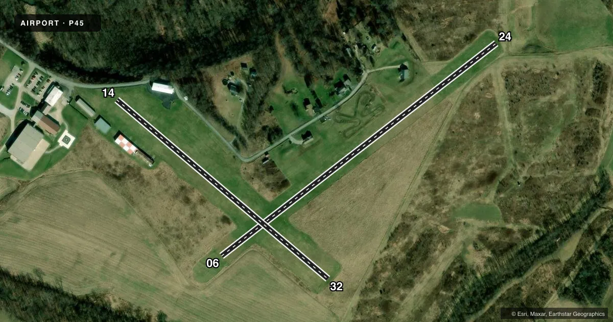
Runways & pattern
Full pagePattern entry · RWY 24
LEFT TRAFFIC| Runway | Heading (°M) | Length | Surface | Traffic |
|---|---|---|---|---|
| 06/24Favored | 45° / 225° | 2,037 ft | TURF | Standard L |
| 14/32 | 122° / 302° | 1,625 ft | TURF | Standard L |
Runway end performance
| End | TORA | TODA | ASDA | LDA | VGSI | Approach lights | Obstruction |
|---|---|---|---|---|---|---|---|
| 06 | — | — | — | — | — | — | 38', trees, 540' from thr, 162' R of cntrln, slope 14 |
| 24 | — | — | — | — | — | — | 11', tree, 61' from thr, 48' R of cntrln, slope 5 |
| 14 | — | — | — | — | — | — | 12', road, 4' from thr, 100' R of cntrln, slope 0 |
| 32 | — | — | — | — | — | — | 25', trees, 204' from thr, 87' R of cntrln, slope 8 |
Declared distances in feet. TORA = takeoff run available, TODA = takeoff distance, ASDA = accelerate-stop, LDA = landing distance.
Airport sketch
Runways drawn to scale from FAA survey coordinates, rendered over satellite imagery. Not for navigation.
Approaches & charts
Services on the field
Fuel grades, oxygen, maintenance, ramp storage and lighting — as declared to the FAA by the airport operator.
Fuel & services
- Fuel
- 100LL
- Oxygen (bottled)
- Not available
- Oxygen (bulk)
- Not available
Ramp & ground
- Transient storage
- Tie-down
- Hangar
- Landing fee
- No fee published
- Customs
- Not available
- Wind indicator
- Yes
- Segmented circle
- No
Fuel & FBOs
Cheapest 100LL and Jet A on the field and nearby. Always confirm with the FBO before taxi.
Airport notes
Surface conditions, obstructions, local procedures, lighting outages and other notes published with each FAA cycle.
General notes
- RWYS UNUSBL DURG SPRING THAW & WET PERIODS.
- EXTSV HEL ACTVTY AT ADJ HELI.
- ULTRALIGHT ACTVTY ON & INVOF ARPT.
- BOTH RWY SFCS ARE ROLLING.
- ULTRALIGHT ACFT USE 500 FT AGL R TFC PAT FOR ALL RWYS.
- WILDLIFE ON & INVOF RWYS.
- RWY NOT MNTND DRG WINTER MONTHS.
- SEASONAL CROPS LCTD ARND RWYS.
- FOR CD CTC JOHNSTOWN APCH AT 814-532-5960, WHEN APCH CLSD CTC CLEVELAND ARTCC AT 440-774-0213.
Runway surface & condition
- 06/24MKD WITH YELLOW CONES.
- 14/32MKD WITH YELLOW CONES.
Approach & departure obstructions
- 14RWY 14 APCH RATIO 20:1 TO 565 FT DTHR.
- 32RWY 32 APCH RATIO 57 FT TREES, 747 FT FM THLD, 64 FT R 17:1 TO 250 FT DTHR.
- 14RD CROSSES CNTRLN 90 FT OUT ANGLING TO L SIDE OF THLD.
Other notes
- VFR OPNS ONLY
VFR map & nearby airports
VFR sectional. Tap any ICAO chip to open that airport.
Key facts · P45
Answer card- ICAO
- P45
- Name
- MOUNT PLEASANT/SCOTTDALE
- Location
- MOUNT PLEASANT, PENNSYLVANIA
- Elevation
- 1,160 ft MSL
- Traffic pattern altitude
- 2,160 ft MSL (1,000 AGL)
- Control tower
- Non-towered (use CTAF)
- Total runways
- 2
- Longest runway
- 06/24 · 2,037 ft
- Published ILS approaches
- 0
- Published frequencies
- 1
- Magnetic variation
- 8°
- Current flight rules
- MVFR
- Current wind
- 230° at 5 kt
- Favored runway now
- RWY 24
Mount Pleasant/Scottdale Airport (P45) sits in Mount Pleasant, Pennsylvania. The field elevation is 1,160 ft MSL. It has two turf runways. The longest is Runway 06/24 at 2,037 ft. Runway 14/32 is 1,625 ft. This is a non-towered field. CTAF is 122.9. No ILS approaches are published, so plan for VFR only. The pattern altitude is not published in the facts. For light piston traffic, use the standard 1,000 ft AGL unless the current Chart Supplement says otherwise. Ultralight traffic uses a 500 ft AGL right pattern on all runways.
The published remarks matter here. Runway 14 has a displaced threshold because of the approach slope. Runway 32 has trees close in on final with another displaced threshold. Both turf runways are marked with yellow cones. The surfaces are rolling. Runways are not maintained during winter months. Seasonal crops are around the airport. There is also extensive helicopter activity at the adjacent heliport, so keep your scan active in the pattern and on taxi. For clearance delivery, contact Johnstown Approach at 814-532-5960. When Approach is closed, contact Cleveland ARTCC at 440-774-0213. No on-field FBOs are listed, so verify services with the airport operator or call the field directly before arrival.