METAR & TAF KFWQ
KFWQ does not publish a METAR.
Showing the nearest reporting station: KAGC (ALLEGHENY COUNTY) · 9.8 NM away. Conditions at KFWQ may differ.
METAR · KAGC
Observed 13:00Z
KAGC 271300Z VRB03KT 6SM HZ CLR 22/19 A2993 RMK AO2 T02220194
- Wind
- VAR @ 3 kt
- Visibility
- 6 SM
- Temp / Dew
- 22°C / 19°C
- Altimeter
- 29.93 inHg
- Clouds
- CLR
- Density alt
- 2,351 ft
- Ceiling
- Unlimited
- Rules
- VFR
Airport info & contacts
Manager on record, flight service, ARTCC, attendance schedule and pattern altitude — published by the FAA and refreshed every 28 days.
Location
- From city
- 5 NM E
- VFR sectional
- DETROIT
- ARTCC
- ZOB · CLEVELAND
- NOTAM facility
- AOO (NOTAM-D)
Airport manager
- Name
- GABE MONZO
- Phone
- 724-379-6980
- Address
- 605 AIRPORT RD, BELLE VERNON PA 15012
Flight service · Hours
- FSS AOO
- ALTOONA1-800-WX-BRIEF
- Attendance
- MON - FRI · 0700 - 1700
Frequencies
Tap any row to copy the frequency to your clipboard.
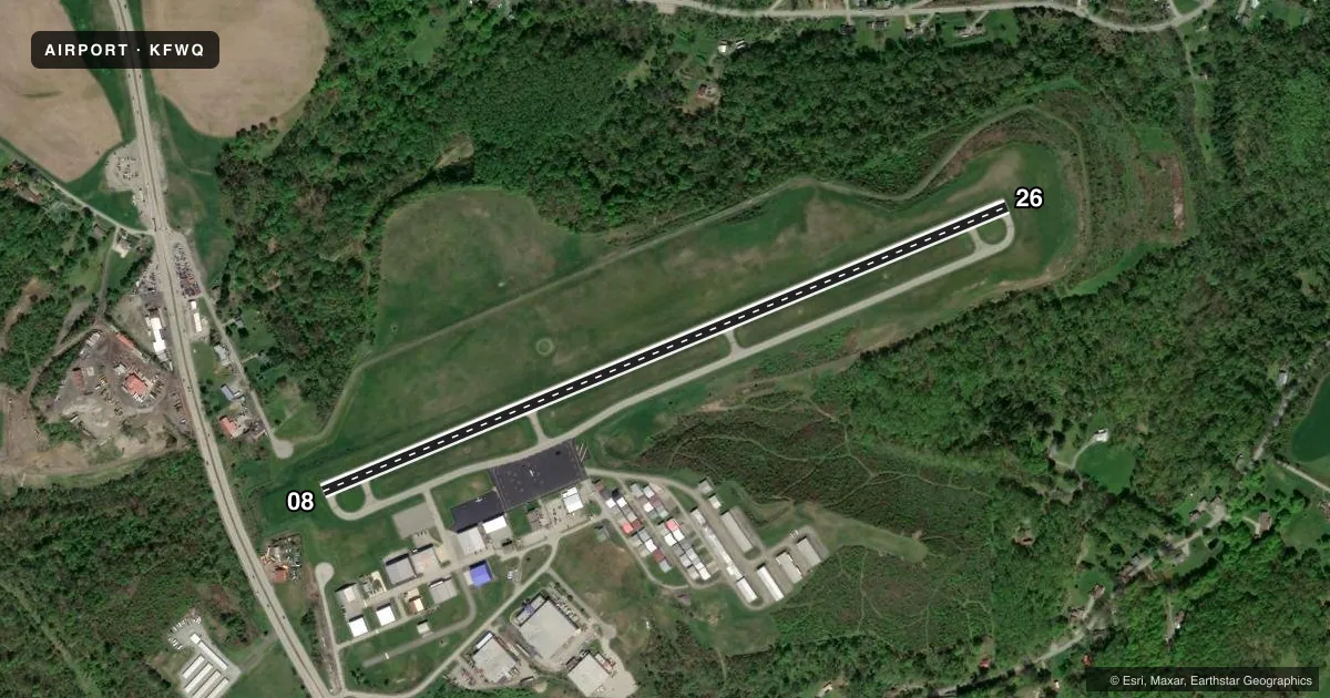
Runways & pattern
Full pagePattern entry · RWY 08
LEFT TRAFFICRunway end performance
| End | TORA | TODA | ASDA | LDA | VGSI | Approach lights | Obstruction |
|---|---|---|---|---|---|---|---|
| 08 | — | — | — | — | VASI 4-box right(3°) | — | 127', tower, 4215' from thr, 245' R of cntrln, slope 31 |
| 26 | — | — | — | — | VASI 4-box left(3°) | — | 59', trees, 2095' from thr, 179' R of cntrln, slope 32 |
Declared distances in feet. TORA = takeoff run available, TODA = takeoff distance, ASDA = accelerate-stop, LDA = landing distance.
Airport sketch
Runways drawn to scale from FAA survey coordinates, rendered over satellite imagery. Not for navigation.
Approaches & charts
Services on the field
Fuel grades, oxygen, maintenance, ramp storage and lighting — as declared to the FAA by the airport operator.
Fuel & services
- Fuel
- 100LLAA+
- Oxygen (bottled)
- Not available
- Oxygen (bulk)
- Not available
- Airframe repair
- Major
- Power plant repair
- Major
- Other services
- AMB,AVNCS,SALES
Ramp & ground
- Transient storage
- Tie-down
- Hangar
- Landing fee
- No fee published
- Customs
- Not available
- Lighting schedule
- SEE RMK
- Beacon schedule
- SS-SR
- Beacon
- White / Green (civil land)(WG)
- Wind indicator
- Lighted
- Segmented circle
- Yes
Fuel & FBOs
Cheapest 100LL and Jet A on the field and nearby. Always confirm with the FBO before taxi.
Airport notes
Surface conditions, obstructions, local procedures, lighting outages and other notes published with each FAA cycle.
General notes
- DEER & BIRDS ON & INVOF ARPT.
- FOR CD CTC PITTSBURGH APCH AT 412-472-5591.
Lighting notes
- ACTVT REIL RWY 08/26; MIRL RWY 08/26 - CTAF.
Approach & departure obstructions
- 08RIGHT TRAFFIC HELICOPTERS/ULTRALIGHTS.
- 26RIGHT TRAFFIC HELICOPTERS/ULTRALIGHTS.
Other notes
- 2AFT HRS CTC 724-640-6349/2409.
VFR map & nearby airports
VFR sectional. Tap any ICAO chip to open that airport.
Key facts · KFWQ
Answer card- ICAO
- KFWQ
- Name
- ROSTRAVER
- Location
- MONONGAHELA, PENNSYLVANIA
- Elevation
- 1,228.2 ft MSL
- Traffic pattern altitude
- 2,228.2 ft MSL (1,000 AGL)
- Control tower
- Non-towered (use CTAF)
- Total runways
- 1
- Longest runway
- 08/26 · 4,002 ft
- Published ILS approaches
- 0
- Published frequencies
- 6
- Magnetic variation
- 9°
- Current flight rules
- VFR
- Current wind
- 000° at 3 kt
- Favored runway now
- RWY 08
Rostraver Airport sits near Monongahela, Pennsylvania. Field elevation is 1,228.2 ft MSL. The airport has one runway, 08/26, at 4,002 ft. There is no control tower. Pittsburgh Approach handles clearance delivery. The published frequencies also include CTAF 122.8. UNICOM is 122.8.
No ILS approaches are published here. Pattern altitude is not published. For light piston traffic, plan on the standard 1,000 ft AGL unless the current Chart Supplement says otherwise. The field has one on-field FBO, Rostraver Airport. It carries 100LL, Jet A and Jet A Prist. The runway end identifier lights are available on 08/26. Medium intensity runway lights are also on 08/26. They are controlled by CTAF. Deer and birds are reported in and around the airport. Keep a sharp scan on arrival and departure.
Helicopters and ultralights use right traffic on runway 08. They also use right traffic on runway 26. If you need clearance delivery, call Pittsburgh Approach at 412-472-5591. After hours contact is listed in the Chart Supplement. Check the current FAA Chart Supplement before flying in for any current noise, lighting, or traffic pattern notes.