METAR & TAF KPJC
Current METAR
Observed 14:15Z
KPJC 191415Z AUTO 00000KT 1 1/2SM OVC003 M08/M08 A2986 RMK AO2
- Wind
- 000° @ 0 kt
- Visibility
- 0.5 SM
- Temp / Dew
- -8°C / -8°C
- Altimeter
- 29.86 inHg
- Clouds
- OVC
- Density alt
- -1,561 ft
- Ceiling
- 300 ft AGL
- Rules
- LIFR
Airport info & contacts
Manager on record, flight service, ARTCC, attendance schedule and pattern altitude — published by the FAA and refreshed every 28 days.
Location
- From city
- 1 NM W
- VFR sectional
- DETROIT
- ARTCC
- ZOB · CLEVELAND
- NOTAM facility
- AOO (NOTAM-D)
Airport manager
- Name
- DAVE HOLMAN
- Phone
- 724-452-4719
- Address
- 220 TASA DRIVE, ZELIENOPLE PA 16063
Flight service · Hours
- FSS AOO
- ALTOONA1-800-WX-BRIEF
- Attendance
- MON-FRI · 0600-2200
- SAT-SUN · ON CALL
Frequencies
Tap any row to copy the frequency to your clipboard.
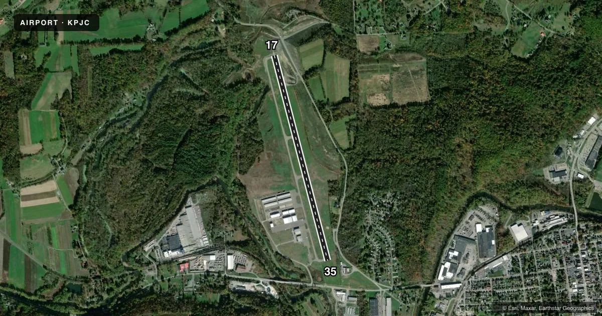
Runways & pattern
Full pagePattern entry · RWY 17
LEFT TRAFFICRunway end performance
| End | TORA | TODA | ASDA | LDA | VGSI | Approach lights | Obstruction |
|---|---|---|---|---|---|---|---|
| 17 | — | — | — | — | — | — | 108', trees, 2138' from thr, 103' R of cntrln, slope 17 |
| 35 | — | — | — | — | PAPI 2-box left(3.48°) | — | 183', hill, 3883' from thr, 496' R of cntrln, slope 20 |
Declared distances in feet. TORA = takeoff run available, TODA = takeoff distance, ASDA = accelerate-stop, LDA = landing distance.
Airport sketch
Runways drawn to scale from FAA survey coordinates, rendered over satellite imagery. Not for navigation.
Approaches & charts
Services on the field
Fuel grades, oxygen, maintenance, ramp storage and lighting — as declared to the FAA by the airport operator.
Fuel & services
- Fuel
- 100LLAA+
- Oxygen (bottled)
- High pressure
- Oxygen (bulk)
- Low pressure
- Airframe repair
- Major
- Power plant repair
- Major
- Other services
- CHTR,INSTR
Ramp & ground
- Transient storage
- Tie-down
- Hangar
- Landing fee
- No fee published
- Customs
- Not available
- Lighting schedule
- SEE RMK
- Beacon schedule
- SS-SR
- Beacon
- White / Green (civil land)(WG)
- Wind indicator
- Lighted
- Segmented circle
- No
Fuel & FBOs
Cheapest 100LL and Jet A on the field and nearby. Always confirm with the FBO before taxi.
Airport notes
Surface conditions, obstructions, local procedures, lighting outages and other notes published with each FAA cycle.
General notes
- DEER & GEESE ON & INVOF RWY.
- FOR CD CTC PITTSBURGH APCH AT 412-472-5591.
Lighting notes
- ACTVT REIL RWY 17 & 35; MIRL RWY 17/35 AFT 2200 - CTAF. PAPI CONS & MIRL OPER DUSK-2200.
Approach & departure obstructions
- 35PAPI UNUSBL BYD 5 DEG L OF CNTRLN.
- 17108 FT TREES; 2138 FT FM THLD, 103 FT LEFT, 17:1 TO THLD.
Other notes
- VFR USE ONLY.
- TIE DOWN ROPES NOT AVBL.
- 1FOR ATTENDANT SAT-SUN CALL 724-452-4719.
VFR map & nearby airports
VFR sectional. Tap any ICAO chip to open that airport.
Key facts · KPJC
Answer card- ICAO
- KPJC
- Name
- ZELIENOPLE MUNI
- Location
- ZELIENOPLE, PENNSYLVANIA
- Elevation
- 907.1 ft MSL
- Traffic pattern altitude
- 1,907.1 ft MSL (1,000 AGL)
- Control tower
- Non-towered (use CTAF)
- Total runways
- 1
- Longest runway
- 17/35 · 5,002 ft
- Published ILS approaches
- 0
- Published frequencies
- 3
- Magnetic variation
- 9°
- Current flight rules
- LIFR
- Current wind
- 000° at 0 kt
- Favored runway now
- –
Zelienople Muni sits in Zelienople, Pennsylvania. The field elevation is 907 ft MSL. It has one runway, 17/35, at 5,002 ft. There is no control tower. VFR use only is published in the remarks, so plan to stay within VFR rules and check the current Chart Supplement before you go.
No ILS approaches are published here. The runway lighting note matters if you are arriving late. Runway end identifier lights are active on 17 and 35. Medium intensity runway lights operate from dusk to 2200. After 2200, the lights are on the CTAF frequency. The precision approach path indicators are constant. The PAPI on runway 35 is unusable more than 5 degrees left of centerline. Deer and geese are reported on and near the runway, so keep a sharp scan on final and during rollout.
Pattern altitude is not published. Use 1,000 ft AGL for light piston traffic unless the current Chart Supplement says otherwise. Pittsburgh Jet Center is on the field. It carries 100LL and Jet A. For clearance delivery, contact Pittsburgh Approach at 412-472-5591. The runway 17 threshold has nearby trees on the approach side. That is worth a close look on a short or low approach.