METAR & TAF KPIT
Current METAR
Observed 15:51Z
KPIT 271551Z 28006KT 10SM BKN027 BKN060 26/21 A2991 RMK AO2 SLP127 T02610206
- Wind
- 280° @ 6 kt
- Visibility
- 10 SM
- Temp / Dew
- 26°C / 21°C
- Altimeter
- 29.91 inHg
- Clouds
- BKN
- Density alt
- 2,824 ft
- Ceiling
- 2,700 ft AGL
- Rules
- MVFR
Airport info & contacts
Manager on record, flight service, ARTCC, attendance schedule and pattern altitude — published by the FAA and refreshed every 28 days.
Location
- From city
- 12 NM NW
- VFR sectional
- DETROIT
- ARTCC
- ZOB · CLEVELAND
- NOTAM facility
- PIT (NOTAM-D)
Airport manager
- Name
- CHRISTINA A. CASSOTIS
- Phone
- (412) 472-3509
- Address
- PO BOX 12370, SUITE 4000, PITTSBURGH PA 15231-0370
Flight service · Hours
- FSS AOO
- ALTOONA1-800-WX-BRIEF
- Attendance
- ALL
Frequencies
Tap any row to copy the frequency to your clipboard.
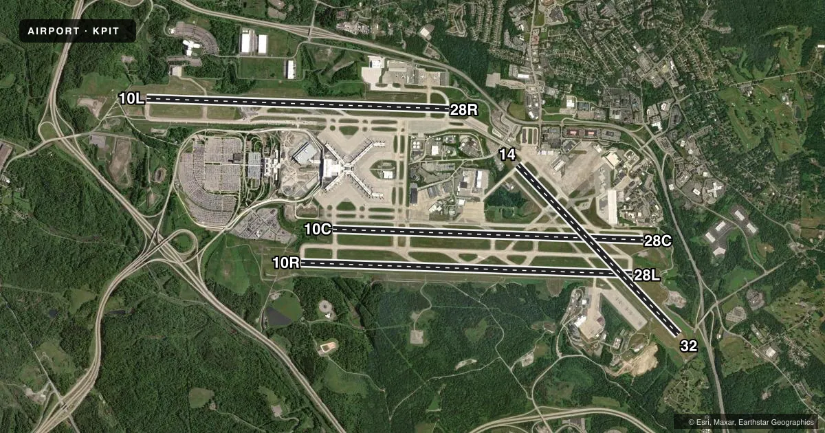
Runways & pattern
Full pagePattern entry · RWY 28L
LEFT TRAFFIC| Runway | Heading (°M) | Length | Surface | Traffic |
|---|---|---|---|---|
| 10R/28LFavored | 83° / 263° | 11,500 ft | CONC | Standard L |
| 10C/28C | 83° / 263° | 10,775 ft | ASPH-CONC | Standard L |
| 10L/28R | 83° / 263° | 10,502 ft | ASPH-CONC | Standard L |
| 14/32 | 127° / 307° | 8,101 ft | CONC | Standard L |
Runway end performance
| End | TORA | TODA | ASDA | LDA | VGSI | Approach lights | Obstruction |
|---|---|---|---|---|---|---|---|
| 10R | 11,500' | 11,500' | 11,492' | 11,492' | PAPI 4-box left(3°) | ALSF2 | 92', trees, 3890' from thr, 930' R of cntrln, slope 40 |
| 28L | 11,500' | 11,500' | 11,500' | 11,500' | PAPI 4-box left(3°) | MALSR | 154', trees, 4954' from thr, 348' R of cntrln, slope 30 |
| 10C | 10,775' | 10,775' | 10,173' | 9,708' | PAPI 4-box left(3°) | — | — |
| 28C | 10,775' | 10,775' | 10,310' | 9,708' | PAPI 4-box left(3°) | — | 58', trees, 2100' from thr, 402' R of cntrln, slope 32 |
| 10L | 10,502' | 10,502' | 10,502' | 10,502' | PAPI 4-box left(3°) | ALSF2 | — |
| 28R | 10,502' | 10,502' | 10,102' | 10,102' | PAPI 4-box left(3°) | MALSR | 107', ant, 4165' from thr, 909' R of cntrln, slope 37 |
| 14 | 8,101' | 8,101' | 7,366' | 7,366' | PAPI 4-box left(3°) | — | 24', pole, 451' from thr, 510' R of cntrln, slope 10 |
| 32 | 8,101' | 8,101' | 7,801' | 7,466' | PAPI 4-box left(3°) | MALS | 42', trees, 1653' from thr, 679' R of cntrln, slope 34 |
Declared distances in feet. TORA = takeoff run available, TODA = takeoff distance, ASDA = accelerate-stop, LDA = landing distance.
Airport sketch
Runways drawn to scale from FAA survey coordinates, rendered over satellite imagery. Not for navigation.
Approaches & charts
ILS · 5
Services on the field
Fuel grades, oxygen, maintenance, ramp storage and lighting — as declared to the FAA by the airport operator.
Fuel & services
- Fuel
- 100LLA
- Oxygen (bottled)
- Not available
- Oxygen (bulk)
- Not available
- Airframe repair
- Minor
- Power plant repair
- Minor
- Other services
- AFRT,CARGO
Ramp & ground
- Transient storage
- Tie-down
- Hangar
- Landing fee
- Yes
- Customs
- Not available
- Beacon schedule
- SS-SR
- Beacon
- White / Green (civil land)(WG)
- Wind indicator
- Lighted
- Segmented circle
- No
Fuel & FBOs
Cheapest 100LL and Jet A on the field and nearby. Always confirm with the FBO before taxi.
Airport notes
Surface conditions, obstructions, local procedures, lighting outages and other notes published with each FAA cycle.
General notes
- DEER & BIRDS ON & INVOF ARPT.
- ACFT USING TWY 'N' PROHIBITED TO STOP ON OVERPASS AREA DUE TO POSSIBLE EMERGENCY EVACUATION HAZARD.
- ANG ACFT MUST CTC TANKER 303.0/FTR OPNS 293.7 BEFORE CROSSING RWY 28L TO OBTAIN CLNC TO ENTER.
- TERML TAXILANES E OF CONCOURSES A & B RESTRD TO GROUP 3 ACFT & SMALLER.
- ATCT IS AUTHORIZED TO HAVE ACFT LINE-UP & WAIT ON RYS 28L AT TWY 'P' DURG HRS OF DARKNESS. THE SPECIFIC RY SHALL BE USED ONLY FOR DEPARTURES & THE INTXN MUST BE VSB FM ATCT.
- SERVICE-JASU: (ANG) (A/M32A-86) (AM 32-95; (AFRC - 2(A/M32-86 (AM32-95).
- SERVICE-FLUID: LPOX LHNIT.
- SERVICE-OIL: O-156.
- SERVICE-TRAN ALERT: NO PRIORITY BASIS.
- ANG: OPR 1130-2030Z++MON-FRI EXCP HOL. (CLSD EV OTH MON). NSTD PAVEMENT MARKINGS ON ANG RAMP. NO TRAN DE-ICE CAPABILITY ON ANG RAMP.
- TWY G INTXN AT RY 10L/28R RIGHT TURN NA.
- FUEL: A++ PROVIDED BY ANG AND AFRC.(MIL).
- PPR/OFFL BUS MIN 48 HR CTC AFLD MGMT DSN 277 8163, C412 474 8163. LTD TRAN SVC. AFLD MGT NML DUTY HRS 1300 0100++ MON, WED, FRI, 1300-0500++ TUE, THU, EXC HOL. UNIT TRAINING ASSEMBLY 1300 2100Z++SAT. TRAN ACFT MUST HAVE APPVL OF 911OG/CC FOR PPR DUR OFF DUTY HR. NO SVC AVBL FOR SPACE AVBL PAX DUR OFF DUTY HR. CALL PITT COMD POST (IRON CITY) BY RDO 15 MIN PRIOR TO ARRIVAL. ALFD MGMT DOES NOT ISSUE OR STOR COMSEC. COMSEC STOR CTC COMD POST DSN 277 8146.
- TWY AA NO TURN-OFF ONTO TWY A FOR ACFT WINGSPAN 171 FT OR GREATER EXC PPR (412) 472-5630.
- MILITARY: CAUTION: BASH PHASE II OPS IN EFFECT 1 JUL - 30 SEP ANNUALLY. UNLESS MSN REQUIREMENTS DIRECT OTHERWISE, FLIGHTS SHOULD NOT BE SKED WITHIN +/-1HR OF SS/SR. TRAN AIRCREW SHOULD REQ BIRD WATCH COND FR AFRC (PITT OPS) ON 252.1 OR ANG OPS (STEEL CTL) ON 311.0. AIRCREW WILL BE INFORMED BY STEEL CONTROL OR PITT OPS (AS APPLICABLE) IF CURRENT BWC IS OTHER THAN LOW REGARDLESS OF BASH PHASE. RSTD - NO HAZ CL/DIV 1.1 EXPLOSIVES PERMITTED.
- TRML APN UNCONTROLLED. PUSHBACK PILOT DESCRETION. DO NOT EXIT TRML APN AT TWY C1, C4, V3, V4, D1, W. CTC GC WHEN HLDG AT TWY C2, C3, V1, V2, V5, V6, D2, D3.
- LDG FEE.
- PUSHBACK CLNC REQUIRED FR GATES A100 AND A101 AT CARGO A. CTC GC. PUSHBACK FM THESE GATES ENTERS TWY N.
- TWY Z BTN TWY P AND HANGAR 7 APRON RSTRD TO ACFT WINGSPAN 118 FT OR LESS.
Fuel notes
- 100LLLOX SOAP (AVBL DURG ANG DUTY HOURS ONLY. 30 MIN PRIOR NOTICE RQRD.).
Runway surface & condition
- 10C/28CPCR VALUE: 804/R/A/W/T
- 10L/28RPCR VALUE: 980/R/A/W/T
- 10R/28LPCR VALUE: 980/R/A/W/T
- 14/32PCR VALUE: 835/R/A/W/T
Approach & departure obstructions
- 10LALSF2/SSALR IS A DUAL MODE SYSTEM & CONTROLLED BY ATCT & REMOTE MONITORED.
Other notes
- IN OPERN PRIOR TO 1959.
- AFRTJASU (MD-3A)(MD-3M)(MA-1A)(M32A-60)(M32A-60A)(MXU-4A).
VFR map & nearby airports
VFR sectional. Tap any ICAO chip to open that airport.
Key facts · KPIT
Answer card- ICAO
- KPIT
- Name
- PITTSBURGH INTL
- Location
- PITTSBURGH, PENNSYLVANIA
- Elevation
- 1,202.9 ft MSL
- Traffic pattern altitude
- 2,202.9 ft MSL (1,000 AGL)
- Control tower
- Towered · 24
- Total runways
- 4
- Longest runway
- 10R/28L · 11,500 ft
- Published ILS approaches
- 5
- Published frequencies
- 31
- Magnetic variation
- 9°
- Current flight rules
- MVFR
- Current wind
- 280° at 6 kt
- Favored runway now
- RWY 28L
Pittsburgh Intl is in Pittsburgh, Pennsylvania. Field elevation is 1,202.9 ft MSL. The airport has 4 runways. The longest is 11,500 ft on 10R/28L. The tower is open 24 hours. Five ILS approaches are published for runway ends 10L, 10R, 28L, 28R and 32. Pattern altitude is not published in the facts, so verify the current Chart Supplement before you fly. For light piston traffic, use the standard 1,000 ft AGL only if current local guidance supports it.
Atlantic Aviation is on the field. It carries 100LL and Jet A. Call them at (412) 472-6700 for current ramp and fuel availability. The airport sits inside the Pittsburgh metro area. Expect busy airline and business traffic. The field is also at a higher elevation than many eastern airports. Performance planning matters on warm days.
A few published remarks matter on the ground. Right turns are not authorized at taxiway G where it meets runway 10L/28R. Taxiway Z between taxiway P and Hangar 7 apron is limited to aircraft with wingspan 118 feet or less. The tower can authorize line up and wait on 28L at taxiway P during darkness. If you are new to KPIT, review the current Chart Supplement and be ready for a complex taxi environment.