METAR & TAF 29D
29D does not publish a METAR.
Showing the nearest reporting station: KUCP (NEW CASTLE MUNI) · 13.3 NM away. Conditions at 29D may differ.
METAR · KUCP
Observed 12:56Z
KUCP 271256Z AUTO 00000KT 10SM CLR 22/21 A2992 RMK AO2 SLP140 T02170206
- Wind
- 000° @ 0 kt
- Visibility
- 10 SM
- Temp / Dew
- 22°C / 21°C
- Altimeter
- 29.92 inHg
- Clouds
- CLR
- Density alt
- 2,540 ft
- Ceiling
- Unlimited
- Rules
- VFR
Airport info & contacts
Manager on record, flight service, ARTCC, attendance schedule and pattern altitude — published by the FAA and refreshed every 28 days.
Location
- From city
- 3 NM W
- VFR sectional
- DETROIT
- ARTCC
- ZOB · CLEVELAND
- NOTAM facility
- AOO (NOTAM-D)
Airport manager
- Name
- MICHAEL BAUN
- Phone
- 724-748-5530
- Address
- GROVE CITY AIRPORT, 40 OAKLEY KELLY DR, MERCER PA 16137-8411
Flight service · Hours
- FSS AOO
- ALTOONA1-800-WX-BRIEF
- Attendance
- MON-FRI · 0800-1600
Frequencies
Tap any row to copy the frequency to your clipboard.
Runways & pattern
Full pagePattern entry · RWY 10
LEFT TRAFFICRunway end performance
| End | TORA | TODA | ASDA | LDA | VGSI | Approach lights | Obstruction |
|---|---|---|---|---|---|---|---|
| 10 | — | — | — | — | PAPI 2-box left(3.8°) | — | 130', trees, 2727' from thr, 453' R of cntrln, slope 19 |
| 28 | — | — | — | — | PAPI 2-box left(3°) | — | — |
Declared distances in feet. TORA = takeoff run available, TODA = takeoff distance, ASDA = accelerate-stop, LDA = landing distance.
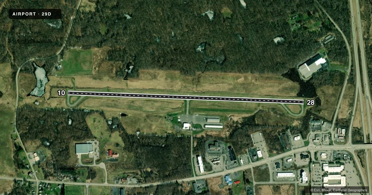
Airport sketch
Runways drawn to scale from FAA survey coordinates, rendered over satellite imagery. Not for navigation.
Approaches & charts
Services on the field
Fuel grades, oxygen, maintenance, ramp storage and lighting — as declared to the FAA by the airport operator.
Fuel & services
- Fuel
- 100LLAA+
- Oxygen (bottled)
- Not available
- Other services
- AMB,PAJA
Ramp & ground
- Transient storage
- Tie-down
- Hangar
- Landing fee
- No fee published
- Customs
- Not available
- Lighting schedule
- SEE RMK
- Beacon schedule
- SS-SR
- Beacon
- White / Green (civil land)(WG)
- Wind indicator
- Lighted
- Segmented circle
- No
Fuel & FBOs
Cheapest 100LL and Jet A on the field and nearby. Always confirm with the FBO before taxi.
Airport notes
Surface conditions, obstructions, local procedures, lighting outages and other notes published with each FAA cycle.
General notes
- DEER & GEESE ON & INVOF ARPT.
- DRAINAGE RAVINE 15 FT DEEP LCTD IN SAFETY AREA N OF RWY 10.
- TWY LGTS STUB TO APRON.
- AVOID OVERFLYING FLD DURG DALGT VFR BECAUSE OF PAJA NW CORNER OF FLD.
- FOR CD CTC YOUNGSTOWN APCH AT 330-856-4806, WHEN APCH CLSD CTC CLEVELAND ARTCC AT 440-774-0234.
- PORTABLE GND PWR UNIT AVBL.
Lighting notes
- ACTVT PAPI RWY 10 & 28; MIRL RWY 10/28 - CTAF.
Fuel notes
- 100LL24 HR FUEL AVBL WITH CREDIT CARD.
- AJET-A ANTI-ICE INHIBITOR AVBL ON REQ.
Approach & departure obstructions
- 10RWY 10 PAPI UNUSBL BYD 5 DEG L OF RWY CNTRLN.
Other notes
- THIS AIRPORT HAS BEEN SURVEYED BY THE NATIONAL GEODETIC SURVEY.
- 1UNATNDD THANKSGIVING, CHRISTMAS & NEW YEARS DAY.
VFR map & nearby airports
VFR sectional. Tap any ICAO chip to open that airport.
Key facts · 29D
Answer card- ICAO
- 29D
- Name
- GROVE CITY
- Location
- GROVE CITY, PENNSYLVANIA
- Elevation
- 1,370.6 ft MSL
- Traffic pattern altitude
- 2,370.6 ft MSL (1,000 AGL)
- Control tower
- Non-towered (use CTAF)
- Total runways
- 1
- Longest runway
- 10/28 · 4,500 ft
- Published ILS approaches
- 0
- Published frequencies
- 4
- Magnetic variation
- 9°
- Current flight rules
- VFR
- Current wind
- 000° at 0 kt
- Favored runway now
- –
Grove City Airport sits in Grove City, Pennsylvania. Field elevation is 1,370.6 ft MSL. It has one runway, 10/28, which is 4,500 ft long on asphalt. There is no control tower. CTAF and UNICOM are both 122.725. Approach and departure service is through Youngstown on 133.95 or 322.3 when available.
No ILS approaches are published here. Pattern altitude is not published, so use the standard 1,000 ft AGL for light piston traffic unless the current Chart Supplement says otherwise. Grove City Aviation is on the field. It carries 100LL, Jet A and Jet A Prist. 24-hour fuel is available with credit card. Call (724) 748-5530 for current service details.
A few operational items matter here. Avoid overflying the field in daylight VFR because of the PAJA northwest corner of the airport. Deer and geese are reported on and near the field. Runway 10 PAPI is available, but it is unusable beyond 5 degrees left of centerline. Medium intensity runway lights for 10/28 are controlled by CTAF. Taxiway lights stop at the apron. The field has a drainage ravine north of runway 10, so stay alert on the ground and in the pattern.