METAR & TAF 04G
04G does not publish a METAR.
Showing the nearest reporting station: KYNG (YOUNGSTOWN/WARREN RGNL) · 8.3 NM away. Conditions at 04G may differ.
METAR · KYNG
Observed 14:51Z
KYNG 271451Z 27006KT 10SM FEW010 BKN150 BKN220 24/21 A2992 RMK AO2 SLP122 T02390211 53003 $
- Wind
- 270° @ 6 kt
- Visibility
- 10 SM
- Temp / Dew
- 24°C / 21°C
- Altimeter
- 29.92 inHg
- Clouds
- BKN
- Density alt
- 2,374 ft
- Ceiling
- 15,000 ft AGL
- Rules
- VFR
Airport info & contacts
Manager on record, flight service, ARTCC, attendance schedule and pattern altitude — published by the FAA and refreshed every 28 days.
Location
- From city
- 2 NM NE
- VFR sectional
- DETROIT
- ARTCC
- ZOB · CLEVELAND
- NOTAM facility
- CLE (NOTAM-D)
Airport manager
- Name
- ARTHUR TOBEY
- Phone
- 330-534-3580
- Address
- 205 CHARLES ST, HUBBARD OH 44425-2108
Flight service · Hours
- FSS CLE
- CLEVELAND1-800-WX-BRIEF
- Attendance
- IREG
Frequencies
Tap any row to copy the frequency to your clipboard.
Runways & pattern
Full pagePattern entry · RWY 20
LEFT TRAFFICRunway end performance
| End | TORA | TODA | ASDA | LDA | VGSI | Approach lights | Obstruction |
|---|---|---|---|---|---|---|---|
| 02 | — | — | — | — | — | — | 40', trees, 201' from thr, 125' R of cntrln, slope 0 |
| 20 | — | — | — | — | — | — | 85', trees, 275' from thr, 100' R of cntrln, slope 0 |
Declared distances in feet. TORA = takeoff run available, TODA = takeoff distance, ASDA = accelerate-stop, LDA = landing distance.
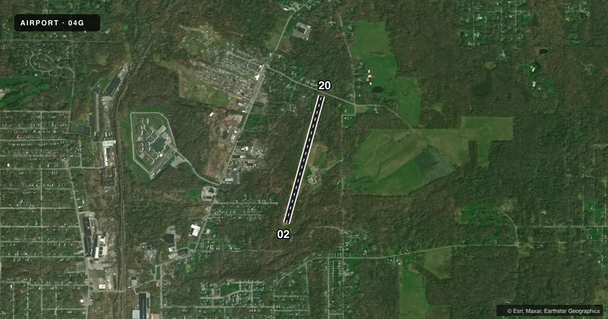
Airport sketch
Runways drawn to scale from FAA survey coordinates, rendered over satellite imagery. Not for navigation.
Approaches & charts
Services on the field
Fuel grades, oxygen, maintenance, ramp storage and lighting — as declared to the FAA by the airport operator.
Fuel & services
- Fuel
- Not available
Ramp & ground
- Transient storage
- Hangar
- Landing fee
- No fee published
- Customs
- Not available
- Wind indicator
- Yes
- Segmented circle
- No
Fuel & FBOs
Cheapest 100LL and Jet A on the field and nearby. Always confirm with the FBO before taxi.
Airport notes
Surface conditions, obstructions, local procedures, lighting outages and other notes published with each FAA cycle.
General notes
- APN IN POOR COND DUE TO BROKEN PAVEMENT, LOOSE STONES, & DEBRIS.
- CTC AMGR BFR LDG FOR PAVEMENT COND.
- DEER, BIRDS, & OTR WILDLIFE ON & INVOF ARPT.
- FOR CD CTC YOUNGSTOWN APCH AT 330-856-4806, WHEN APCH CLSD CTC CLEVELAND ARTCC AT 440-774-0227/0490.
Approach & departure obstructions
- 02+0-50 FT BRUSH/TREES, 0-200 FT DIST FM THR, 125 FT L/R; +0-50 FT BRUSH/TREES, 0-305 FT DIST FM DTHR, 25-125 FT L/R.
- 20+0-65 FT BRUSH & TREES, 35-200 FT DIST, 125 FT L/R; +15 FT ROAD, 75 FT DIST, 125 FT L/R.
- 02CALM WIND RWY.
- 02FADED.
- 20FADED.
- 02NSTD BASIC DUE TO SML NRS & SML CNTRLN WITH NSTD SPACING.
- 20NSTD BASIC DUE TO SML NRS & SML CNTRLN WITH NSTD SPACING.
- 02OBSTN CLNC SLP 0:1 OVR 40 FT TREE, 201 FT DIST, 120 FT L; 0-40 FT BRUSH/TREES, 0 FT B; 0-40-FT BRUSH/TREES, 0 FT DIST, 25-125 L/R, 0:1.
- 20OBSTN CLNC SLP 0:1 OVR 85 FT TREE, 275 FT DIST, 100 FT R; 20-60 FT TREES, 0 FT B.
Other notes
- THIS AIRPORT HAS BEEN SURVEYED BY THE NATIONAL GEODETIC SURVEY.
- PRIOR CDN RQRD FOR TSNT HNGR.
- MANAGEROR 330-233-0044.
- 02/20NMRS UNSEALED CRACKS.
- 02/20SOUTH 305 FT CHEVRONED PAVEMENT HAS LRG DEPRESSIONS, DO NOT OPR IN THIS AREA.
VFR map & nearby airports
VFR sectional. Tap any ICAO chip to open that airport.
Key facts · 04G
Answer card- ICAO
- 04G
- Name
- LANSDOWNE
- Location
- YOUNGSTOWN, OHIO
- Elevation
- 1,043.8 ft MSL
- Traffic pattern altitude
- 2,043.8 ft MSL (1,000 AGL)
- Control tower
- Non-towered (use CTAF)
- Total runways
- 1
- Longest runway
- 02/20 · 3,073 ft
- Published ILS approaches
- 0
- Published frequencies
- 4
- Magnetic variation
- 8°
- Current flight rules
- VFR
- Current wind
- 270° at 6 kt
- Favored runway now
- RWY 20
Lansdowne Airport sits in Youngstown, Ohio. The field elevation is 1,043.8 ft MSL. It has one runway. Runway 02/20 is 3,073 ft long and asphalt. There is no control tower. The airport uses CTAF 122.8 and UNICOM 122.8. Approach and departure service is on 133.95 MHz and 322.3 MHz through Youngstown.
No ILS approaches are published here. The pattern altitude is not published, so use the standard 1,000 ft AGL for light piston operations unless the current FAA Chart Supplement says otherwise. That puts the traffic pattern at about 2,044 ft MSL based on field elevation. Verify the published pattern before you fly.
There are no on-field FBOs listed. Contact the airport operator directly or call the field on CTAF or UNICOM for current services. The published remarks matter here. Deer, birds and other wildlife are reported on and near the airport. The apron is in poor condition with broken pavement, loose stones and debris. Runway 20 has faded and nonstandard markings. The south 305 ft of pavement on Runway 02/20 has large depressions and should not be used. Expect trees and brush close to both runway ends. Runway 02 is listed as the calm wind runway. For clearance delivery, contact Youngstown Approach. If approach is closed, use Cleveland ARTCC. A first-time pilot should plan a careful taxi and landing roll. Verify runway condition and obstacle picture before committing.