METAR & TAF 62D
62D does not publish a METAR.
Showing the nearest reporting station: KYNG (YOUNGSTOWN/WARREN RGNL) · 11.2 NM away. Conditions at 62D may differ.
METAR · KYNG
Observed 11:51Z
KYNG 271151Z 23005KT 5SM BR FEW060 BKN250 20/19 A2991 RMK AO2 SLP121 T02000194 10200 20172 53007 $
- Wind
- 230° @ 5 kt
- Visibility
- 5 SM
- Temp / Dew
- 20°C / 19°C
- Altimeter
- 29.91 inHg
- Clouds
- BKN
- Density alt
- 1,735 ft
- Ceiling
- 25,000 ft AGL
- Rules
- MVFR
Airport info & contacts
Manager on record, flight service, ARTCC, attendance schedule and pattern altitude — published by the FAA and refreshed every 28 days.
Location
- From city
- 5 NM NW
- VFR sectional
- DETROIT
- ARTCC
- ZOB · CLEVELAND
- NOTAM facility
- CLE (NOTAM-D)
Airport manager
- Name
- MARK PAUL
- Phone
- 330-883-3989
- Address
- 3599 HERR FIELDHOUSE RD, SOUTHINGTON OH 44470-9564
Flight service · Hours
- FSS CLE
- CLEVELAND1-800-WX-BRIEF
- Attendance
- IREG
Frequencies
Tap any row to copy the frequency to your clipboard.
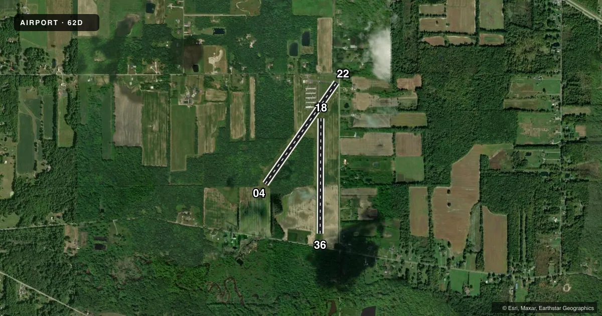
Runways & pattern
Full pagePattern entry · RWY 22
LEFT TRAFFIC| Runway | Heading (°M) | Length | Surface | Traffic |
|---|---|---|---|---|
| 04/22Favored | 28° / 208° | 2,907 ft | ASPH | Standard L |
| 18/36 | 173° / 353° | 2,700 ft | TURF | Standard L |
Runway end performance
| End | TORA | TODA | ASDA | LDA | VGSI | Approach lights | Obstruction |
|---|---|---|---|---|---|---|---|
| 04 | — | — | — | — | — | — | 75', trees, 788' from thr, 221' R of cntrln, slope 7 |
| 22 | — | — | — | — | — | — | 110', trees, 329' from thr, 156' R of cntrln, slope 1 |
| 18 | — | — | — | — | — | — | 95', trees, 1075' from thr, 120' R of cntrln, slope 11 |
| 36 | — | — | — | — | — | — | 75', trees, 110' from thr, 38' R of cntrln, slope 1 |
Declared distances in feet. TORA = takeoff run available, TODA = takeoff distance, ASDA = accelerate-stop, LDA = landing distance.
Airport sketch
Runways drawn to scale from FAA survey coordinates, rendered over satellite imagery. Not for navigation.
Approaches & charts
Services on the field
Fuel grades, oxygen, maintenance, ramp storage and lighting — as declared to the FAA by the airport operator.
Fuel & services
- Fuel
- 100LLMOGAS
- Oxygen (bottled)
- Not available
- Oxygen (bulk)
- Not available
- Airframe repair
- Not available
- Power plant repair
- Not available
Ramp & ground
- Transient storage
- Tie-down
- Hangar
- Landing fee
- No fee published
- Customs
- Not available
- Wind indicator
- Yes
- Segmented circle
- No
Fuel & FBOs
Cheapest 100LL and Jet A on the field and nearby. Always confirm with the FBO before taxi.
Airport notes
Surface conditions, obstructions, local procedures, lighting outages and other notes published with each FAA cycle.
General notes
- DALGT OPS ONLY.
- FOR CD CTC YOUNGSTOWN APCH AT 330-856-4806, WHEN APCH CLSD CTC CLEVELAND ARTCC AT 440-774-0232/0490.
Fuel notes
- 100LLFUEL AVBL H24 VIA CREDIT CARD.
Runway surface & condition
- 18/36-3 FT DITCH EACH SIDE OF RWY EDGE.
Approach & departure obstructions
- 2223 FT PLINE MKD WITH BALLS, 0 FT DIST, 125 FT R; 60 FT TREE, 160 FT DIST.
- 18YELLOW & ORANGE BUCKETS.
- 36YELLOW & ORANGE BUCKETS.
- 22APCH SLP 6:1 TO DTHR OVR 110 FT TREE, 326 FT DIST, 156 FT L.
- 36APCH SLP 11:1 TO DTHR OVR 75 FT TREES, 675 FT DIST, 0 FT B.
Other notes
- THIS AIRPORT HAS BEEN SURVEYED BY THE NATIONAL GEODETIC SURVEY.
- VFR ONLY.
- PRIOR CDN RQRD.
- MANAGERCELL.
- OWNERUNATNDD ARPT TEL.
VFR map & nearby airports
VFR sectional. Tap any ICAO chip to open that airport.
Key facts · 62D
Answer card- ICAO
- 62D
- Name
- WARREN
- Location
- WARREN, OHIO
- Elevation
- 905 ft MSL
- Traffic pattern altitude
- 1,905 ft MSL (1,000 AGL)
- Control tower
- Non-towered (use CTAF)
- Total runways
- 2
- Longest runway
- 04/22 · 2,907 ft
- Published ILS approaches
- 0
- Published frequencies
- 2
- Magnetic variation
- 7°
- Current flight rules
- MVFR
- Current wind
- 230° at 5 kt
- Favored runway now
- RWY 22
Warren Airport sits in Warren, Ohio. Field elevation is 905 ft MSL. The airport has 2 runways. The longest is runway 04/22 at 2,907 ft. There is no control tower. CTAF and UNICOM are both 122.8. No ILS approaches are published here.
Pattern altitude is not published. Use the standard 1,000 ft AGL pattern for light piston operations unless the current Chart Supplement says otherwise. Warren Airport is VFR only. Daylight operations only are published. Prior coordination is required. The on-field FBO is Warren Airport. It carries 100LL and MOGAS. 100LL is available 24 hours a day via credit card. The unattended airport phone is available. Manager contact is by cell phone.
A first-time pilot should pay close attention to the runway 22 and runway 36 notes. Runway 22 has a displaced threshold with tree and power line obstructions on approach. Runway 36 also has tree obstructions on approach. Runway 18/36 is turf. Ditching runs along both runway edges. Yellow and orange buckets mark the ends of runways 18 and 36. With no tower and no published ILS, this is a field where a careful preflight and a current Chart Supplement check matter.