METAR & TAF 7G8
7G8 does not publish a METAR.
Showing the nearest reporting station: KPOV (PORTAGE COUNTY) · 16.7 NM away. Conditions at 7G8 may differ.
METAR · KPOV
Observed 07:55Z
KPOV 240755Z AUTO 33004KT 10SM CLR 13/10 A3012 RMK AO2 T01260101 PWINO
- Wind
- 330° @ 4 kt
- Visibility
- 10 SM
- Temp / Dew
- 13°C / 10°C
- Altimeter
- 30.12 inHg
- Clouds
- CLR
- Density alt
- 968 ft
- Ceiling
- Unlimited
- Rules
- VFR
Airport info & contacts
Manager on record, flight service, ARTCC, attendance schedule and pattern altitude — published by the FAA and refreshed every 28 days.
Location
- From city
- 1 NM SE
- VFR sectional
- DETROIT
- Pattern altitude
- 1,025 ft AGL · 2,199 ft MSL
- ARTCC
- ZOB · CLEVELAND
- NOTAM facility
- CLE (NOTAM-D)
Airport manager
- Name
- RICHARD BLAMER
- Phone
- 440-632-1884
- Address
- PO BOX 1308, MIDDLEFIELD OH 44062-1308
Flight service · Hours
- FSS CLE
- CLEVELAND1-800-WX-BRIEF
- Attendance
- MON-FRI · 0900-1700 IREG
Frequencies
Tap any row to copy the frequency to your clipboard.
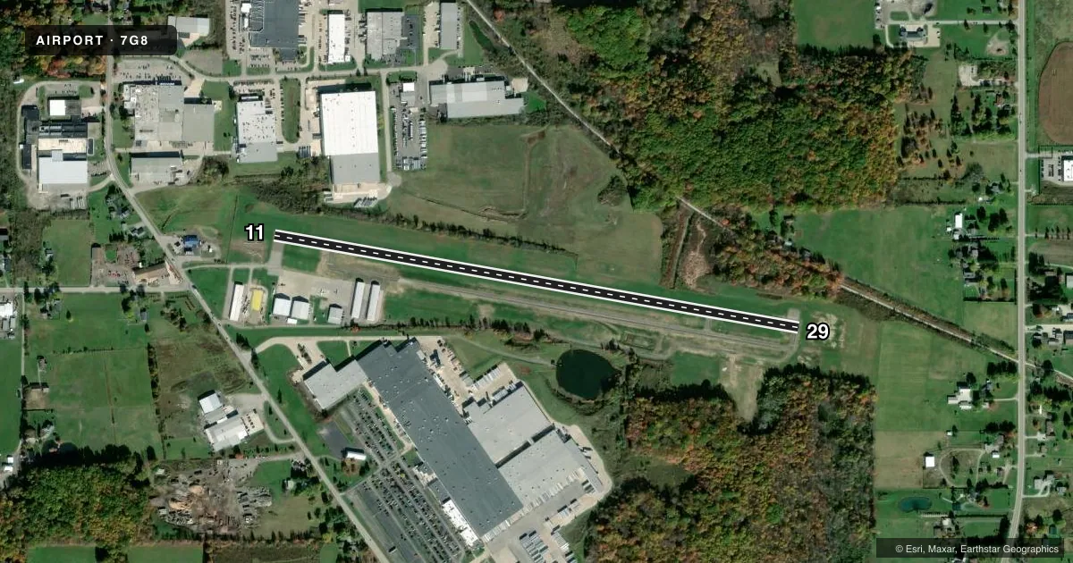
Runways & pattern
Full pagePattern entry · RWY 29
LEFT TRAFFICRunway end performance
| End | TORA | TODA | ASDA | LDA | VGSI | Approach lights | Obstruction |
|---|---|---|---|---|---|---|---|
| 11 | — | — | — | — | — | — | 45', ant, 551' from thr, 160' R of cntrln, slope 7 |
| 29 | — | — | — | — | PAPI 2-box left(3°) | — | — |
Declared distances in feet. TORA = takeoff run available, TODA = takeoff distance, ASDA = accelerate-stop, LDA = landing distance.
Airport sketch
Runways drawn to scale from FAA survey coordinates, rendered over satellite imagery. Not for navigation.
Approaches & charts
Services on the field
Fuel grades, oxygen, maintenance, ramp storage and lighting — as declared to the FAA by the airport operator.
Fuel & services
- Fuel
- 100LLMOGAS
- Oxygen (bottled)
- Not available
- Oxygen (bulk)
- Not available
- Airframe repair
- Not available
- Power plant repair
- Not available
- Other services
- AMB,GLD,TOW
Ramp & ground
- Transient storage
- Tie-down
- Hangar
- Landing fee
- No fee published
- Customs
- Not available
- Lighting schedule
- SEE RMK
- Beacon schedule
- SS-SR
- Beacon
- White / Green (civil land)(WG)
- Wind indicator
- Lighted
- Segmented circle
- No
Fuel & FBOs
Cheapest 100LL and Jet A on the field and nearby. Always confirm with the FBO before taxi.
Airport notes
Surface conditions, obstructions, local procedures, lighting outages and other notes published with each FAA cycle.
General notes
- PARL TWY EAST OF TEE HNGRS CLSD PERMLY.
- EXTSV GLDR ACT ON & INVOF ARPT.
- DEER, BIRDS, & OTR WILDLIFE ON & INVOF ARPT.
- FOR CD CTC CLEVELAND APCH AT 216-352-2323.
- ADZY ONLY WX AVBL - 4 CLICKS CTAF.
Lighting notes
- ACTVT REIL RWY 11 & 29; PAPI RWY 29; MIRL RWY 11/29 - CTAF.
Fuel notes
- 100LL100LL AVBL H24 VIA CREDIT CARD.
Approach & departure obstructions
- 11+3-6 FT BRUSH, 0-140 FT DIST, 220 FT L.
- 11APCH RATIO 16:1 TO DTHR.
Other notes
- SUBJ AVBLTY.
- ROPES NOT PRVDD.
- MANAGER7G8MANAGER@GMAIL.COM.
- MANAGERCELL 216-509-8858.
VFR map & nearby airports
VFR sectional. Tap any ICAO chip to open that airport.
Key facts · 7G8
Answer card- ICAO
- 7G8
- Name
- GEAUGA COUNTY
- Location
- MIDDLEFIELD, OHIO
- Elevation
- 1,174.3 ft MSL
- Traffic pattern altitude
- 2,199.3 ft MSL (1,025 AGL)
- Control tower
- Non-towered (use CTAF)
- Total runways
- 1
- Longest runway
- 11/29 · 3,500 ft
- Published ILS approaches
- 0
- Published frequencies
- 4
- Magnetic variation
- 9°
- Current flight rules
- VFR
- Current wind
- 330° at 4 kt
- Favored runway now
- RWY 29
Geauga County Airport sits in Middlefield, Ohio. The field elevation is 1,174.3 ft MSL. It has one runway, 11/29, which is 3,500 ft of asphalt. There is no control tower. Pattern altitude is 1,025 ft AGL, which is 2,199.3 ft MSL.
No ILS approaches are published here. Cleveland Approach handles clearance delivery and approach or departure work on 125.35 and 346.325. CTAF and UNICOM are both 123.0. The airport is lit by CTAF activation. Runway end identifier lights are on 11 and 29. Runway 29 also has a PAPI. The published remarks also note advisory weather by four clicks on CTAF.
Geauga County Airport has one on-field FBO, Geauga County Airport. It carries AVGAS 100LL. Call the FBO directly at (440) 632-1884 for current availability. Published remarks also note extensive glider activity on and near the airport. Deer, birds and other wildlife are also reported in the area. Runway 11 has a displaced-threshold approach note and brush reported off the left side near that end. Plan your arrival with that in mind. The parallel taxiway east of the tee hangars is permanently closed.