METAR & TAF 2G1
2G1 does not publish a METAR.
Showing the nearest reporting station: KLNN (LAKE COUNTY EXEC) · 8.7 NM away. Conditions at 2G1 may differ.
METAR · KLNN
Observed 13:15Z
KLNN 271315Z AUTO 26009KT 10SM CLR 24/19 A2988 RMK AO1 T02350194
- Wind
- 260° @ 9 kt
- Visibility
- 10 SM
- Temp / Dew
- 24°C / 19°C
- Altimeter
- 29.88 inHg
- Clouds
- CLR
- Density alt
- 2,368 ft
- Ceiling
- Unlimited
- Rules
- VFR
Airport info & contacts
Manager on record, flight service, ARTCC, attendance schedule and pattern altitude — published by the FAA and refreshed every 28 days.
Location
- From city
- 4 NM SSE
- VFR sectional
- DETROIT
- ARTCC
- ZOB · CLEVELAND
- NOTAM facility
- CLE (NOTAM-D)
Airport manager
- Name
- CONNIE LUHTA
- Phone
- 440-227-1368
- Address
- 12253 CONCORD-HAMBDEN RD, PAINESVILLE OH 44077-9566
Flight service · Hours
- FSS CLE
- CLEVELAND1-800-WX-BRIEF
- Attendance
- IREG
Frequencies
Tap any row to copy the frequency to your clipboard.
Runways & pattern
Full pagePattern entry · RWY 21
LEFT TRAFFICRunway end performance
| End | TORA | TODA | ASDA | LDA | VGSI | Approach lights | Obstruction |
|---|---|---|---|---|---|---|---|
| 03 | — | — | — | — | — | — | 73', trees, 258' from thr, 64' R of cntrln, slope 1 |
| 21 | — | — | — | — | — | — | 75', trees, 201' from thr, 121' R of cntrln, slope 1 |
Declared distances in feet. TORA = takeoff run available, TODA = takeoff distance, ASDA = accelerate-stop, LDA = landing distance.
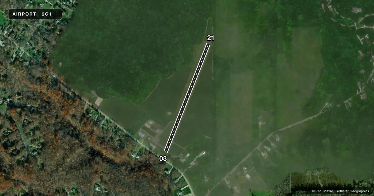
Airport sketch
Runways drawn to scale from FAA survey coordinates, rendered over satellite imagery. Not for navigation.
Approaches & charts
Services on the field
Fuel grades, oxygen, maintenance, ramp storage and lighting — as declared to the FAA by the airport operator.
Fuel & services
- Fuel
- Not available
- Oxygen (bottled)
- Not available
- Oxygen (bulk)
- Not available
Ramp & ground
- Transient storage
- Tie-down
- Hangar
- Landing fee
- No fee published
- Customs
- Not available
- Wind indicator
- Yes
- Segmented circle
- No
Fuel & FBOs
Cheapest 100LL and Jet A on the field and nearby. Always confirm with the FBO before taxi.
Airport notes
Surface conditions, obstructions, local procedures, lighting outages and other notes published with each FAA cycle.
General notes
- BIRDS ON & INVOF ARPT.
- FOR CD CTC CLEVELAND APCH AT 216-352-2323.
- NGT OPS NA.
Approach & departure obstructions
- 0340 FT TREES 50-199 FT DSTC 125 FT L & R.
- 2120-50 FT TREES 0 FT DSTC.
- 03FADED.
- 21FADED.
Other notes
- THIS AIRPORT HAS BEEN SURVEYED BY THE NATIONAL GEODETIC SURVEY.
- ESTABD BFR FAA ACT.
- PPR FOR HNGR.
- TIEDOWN ROPES NOT PRVDD.
- 03/21EXTSV PAVEMENT CRACKING WI VEGETATION GROWING THRU.
VFR map & nearby airports
VFR sectional. Tap any ICAO chip to open that airport.
Key facts · 2G1
Answer card- ICAO
- 2G1
- Name
- CONCORD AIRPARK
- Location
- PAINESVILLE, OHIO
- Elevation
- 998.6 ft MSL
- Traffic pattern altitude
- 1,998.6 ft MSL (1,000 AGL)
- Control tower
- Non-towered (use CTAF)
- Total runways
- 1
- Longest runway
- 03/21 · 2,181 ft
- Published ILS approaches
- 0
- Published frequencies
- 4
- Magnetic variation
- 7°
- Current flight rules
- VFR
- Current wind
- 260° at 9 kt
- Favored runway now
- RWY 21
Concord Airpark is in Painesville, Ohio. Field elevation is 998.6 ft MSL. The airport has one runway, 03/21, which is 2,181 ft long on asphalt. There is no control tower. No ILS approaches are published. The pattern altitude is not published, so plan on the standard 1,000 ft AGL for light piston traffic unless the current Chart Supplement says otherwise.
This is a small field with some real operating limits. Birds are reported on and near the airport. Night operations are not authorized. Runway 03/21 has extensive pavement cracking with vegetation growing through it. Runway 03 markings are faded. Runway 21 markings are faded. There are also trees near both ends. Runway 03 has 40-foot trees off the sides. Runway 21 has 20 to 50-foot trees at zero feet distance from the runway end. That makes a careful look at performance, wind and runway condition important before you commit.
There are no on-field FBOs listed. CTAF and UNICOM are both 122.8. For clearance delivery, contact Cleveland Approach at 216-352-2323. If you need current airport services or hangar access, verify with the airport operator or call ahead. Tiedown ropes are not provided. Prior permission is required for hangar use.