METAR & TAF KGKJ
Current METAR
Observed 16:53Z
KGKJ 271653Z AUTO 25011G16KT 10SM FEW029 BKN041 BKN049 27/20 A2990 RMK AO2 SLP114 T02670200
- Wind
- 250° @ 11G16 kt
- Visibility
- 10 SM
- Temp / Dew
- 27°C / 20°C
- Altimeter
- 29.90 inHg
- Clouds
- BKN
- Density alt
- 3,200 ft
- Ceiling
- 4,100 ft AGL
- Rules
- VFR
Airport info & contacts
Manager on record, flight service, ARTCC, attendance schedule and pattern altitude — published by the FAA and refreshed every 28 days.
Location
- From city
- 3 NM W
- VFR sectional
- DETROIT
- ARTCC
- ZOB · CLEVELAND
- NOTAM facility
- GKJ (NOTAM-D)
Airport manager
- Name
- KEITH A. CHIOCCO
- Phone
- 814-720-2261
- Address
- 16306 CORPORATE DR, MEADVILLE PA 16335
Flight service · Hours
- FSS AOO
- ALTOONA1-800-WX-BRIEF
- Attendance
- 0800-1600
Frequencies
Tap any row to copy the frequency to your clipboard.
Runways & pattern
Full pagePattern entry · RWY 25
LEFT TRAFFICRunway end performance
| End | TORA | TODA | ASDA | LDA | VGSI | Approach lights | Obstruction |
|---|---|---|---|---|---|---|---|
| 07 | — | — | — | — | VASI 4-box left(3°) | — | 50', trees, 1089' from thr, 335' R of cntrln, slope 17 |
| 25 | — | — | — | — | PAPI 4-box left(3°) | MALS | — |
Declared distances in feet. TORA = takeoff run available, TODA = takeoff distance, ASDA = accelerate-stop, LDA = landing distance.
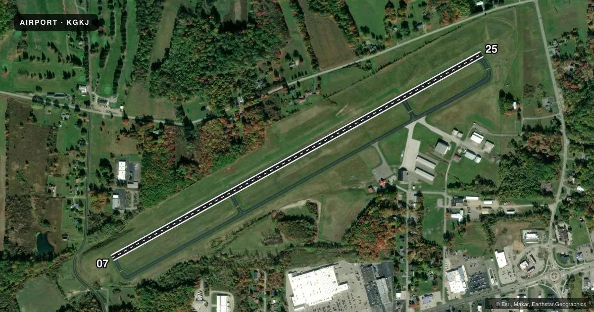
Airport sketch
Runways drawn to scale from FAA survey coordinates, rendered over satellite imagery. Not for navigation.
Approaches & charts
ILS · 1
Services on the field
Fuel grades, oxygen, maintenance, ramp storage and lighting — as declared to the FAA by the airport operator.
Fuel & services
- Fuel
- 100LLA
- Oxygen (bottled)
- Not available
- Oxygen (bulk)
- Not available
- Airframe repair
- Major
- Power plant repair
- Major
- Other services
- AMB,INSTR
Ramp & ground
- Transient storage
- Tie-down
- Hangar
- Landing fee
- Yes
- Customs
- Not available
- Lighting schedule
- SEE RMK
- Beacon schedule
- SS-SR
- Beacon
- White / Green (civil land)(WG)
- Wind indicator
- Lighted
- Segmented circle
- No
Fuel & FBOs
Cheapest 100LL and Jet A on the field and nearby. Always confirm with the FBO before taxi.
Airport notes
Surface conditions, obstructions, local procedures, lighting outages and other notes published with each FAA cycle.
General notes
- BIRDS, DEER & GND HOGS ON & INVOF ARPT.
- TRML BLDG CLSD MAJOR HOL. CALL AHD TO COORD SVC.
- FOR CD CTC YOUNGSTOWN APCH AT 330-856-4806, WHEN APCH CLSD CTC CLEVELAND ARTCC AT 440-774-0232.
- DURING WINTER MONTHS RWY & AFLD PAVEMENTS MAY NOT BE MNTND, CALL FOR FICON.
- DURG SUMMER MONTHS MOWING OPS ADJ TO RWY IN PROG DLY.
- TURF OPNS AREA LCTD N OF RWY & MKD W/CONES. TURF OPNS AUTH JUN THRU OCT FM SR TO SS UNLESS CLSD BY NOTAM. TURF OPNS NOT AUTH DURG INCLEMENT WX. CTC AMGR FOR TURF OPNS AREA CONDS.
- ADNL INFO ON TURF OPNS PROC CAN BE FOUND ON ARPT WEBSITE.
Lighting notes
- ACTVT MALS RWY 25; PAPI RWY 25; VASI RWY 07; MIRL RWY 07/25 - CTAF.
Fuel notes
- AJET A ANTI-ICE AVBL O/R.
Other notes
- IN OPERN PRIOR TO 1959.
- LANDING FEES VARY, CALL AIRPORT AT 814-333-2677 FOR FEE AMOUNTS.
- TIE DOWN ROPES ARE NOT SUPPLIED.
- OWNERCRAWFORD COUNTY REGIONAL AIRPORT AUTHORITY.
VFR map & nearby airports
VFR sectional. Tap any ICAO chip to open that airport.
Key facts · KGKJ
Answer card- ICAO
- KGKJ
- Name
- PORT MEADVILLE
- Location
- MEADVILLE, PENNSYLVANIA
- Elevation
- 1,399.4 ft MSL
- Traffic pattern altitude
- 2,399.4 ft MSL (1,000 AGL)
- Control tower
- Non-towered (use CTAF)
- Total runways
- 1
- Longest runway
- 07/25 · 5,001 ft
- Published ILS approaches
- 1
- Published frequencies
- 5
- Magnetic variation
- 8°
- Current flight rules
- VFR
- Current wind
- 250° at 11 kt
- Favored runway now
- RWY 25
Port Meadville Airport is in Meadville, Pennsylvania. The field elevation is 1,399.4 ft MSL. It has one runway, 07/25, which is 5,001 ft long. There is no control tower. The airport uses CTAF 123.0 and UNICOM 123.0. The published ILS is for runway 25. Pattern altitude is not published, so use the standard 1,000 ft AGL for light piston operations unless the current Chart Supplement says otherwise.
Port Meadville Airport is served by Port Meadville Airport on the field. It carries AVGAS 100LL, Jet A and Jet A Prist. Jet A with anti-ice is available on request. The airport is under the Crawford County Regional Airport Authority. Clearance delivery is handled through Youngstown Approach when needed. The published remarks also note that the terminal building is closed on major holidays. Call ahead if you need service.
This is a field where seasonal conditions matter. Turf operations are north of the runway and marked with cones. They are authorized June through October from sunrise to sunset unless closed by NOTAM. Winter pavement maintenance may be limited. Summer mowing can be active near the runway. Runway 25 has MALSR and PAPI. Runway 07 has VASI. If you are planning a first visit, check the current FAA Chart Supplement and call ahead for field condition and service details.