METAR & TAF 6G1
6G1 does not publish a METAR.
Showing the nearest reporting station: KFKL (VENANGO RGNL) · 14.9 NM away. Conditions at 6G1 may differ.
METAR · KFKL
Observed 18:56Z
KFKL 251856Z AUTO 17006KT 10SM FEW034 SCT055 26/18 A3004 RMK AO2 SLP165 T02610183
- Wind
- 170° @ 6 kt
- Visibility
- 10 SM
- Temp / Dew
- 26°C / 18°C
- Altimeter
- 30.04 inHg
- Clouds
- SCT
- Density alt
- 3,155 ft
- Ceiling
- Unlimited
- Rules
- VFR
Airport info & contacts
Manager on record, flight service, ARTCC, attendance schedule and pattern altitude — published by the FAA and refreshed every 28 days.
Location
- From city
- 3 NM W
- VFR sectional
- DETROIT
- ARTCC
- ZOB · CLEVELAND
- NOTAM facility
- AOO (NOTAM-D)
Airport manager
- Name
- NEIL FRATUS
- Phone
- 814-827-5300
- Address
- CITY OF TITUSVILLE, 107 NORTH FRANKLIN STREET, TITUSVILLE PA 16354
Flight service · Hours
- FSS AOO
- ALTOONA1-800-WX-BRIEF
- Attendance
- Unattended
Frequencies
Tap any row to copy the frequency to your clipboard.
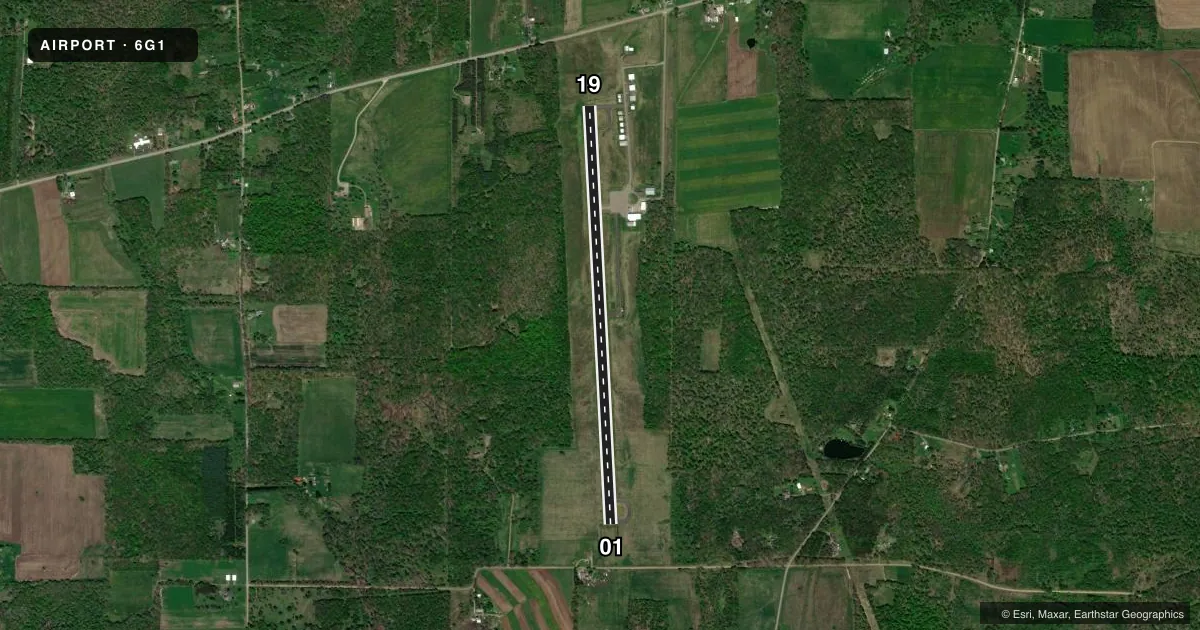
Runways & pattern
Full pagePattern entry · RWY 19
LEFT TRAFFICRunway end performance
| End | TORA | TODA | ASDA | LDA | VGSI | Approach lights | Obstruction |
|---|---|---|---|---|---|---|---|
| 01 | — | — | — | — | — | — | 66', trees, 551' from thr, 253' R of cntrln, slope 5 |
| 19 | — | — | — | — | — | — | 42', tree, 989' from thr, 282' R of cntrln, slope 18 |
Declared distances in feet. TORA = takeoff run available, TODA = takeoff distance, ASDA = accelerate-stop, LDA = landing distance.
Airport sketch
Runways drawn to scale from FAA survey coordinates, rendered over satellite imagery. Not for navigation.
Approaches & charts
Services on the field
Fuel grades, oxygen, maintenance, ramp storage and lighting — as declared to the FAA by the airport operator.
Fuel & services
- Fuel
- 100LLA
- Oxygen (bottled)
- Not available
- Oxygen (bulk)
- Not available
- Airframe repair
- Minor
- Power plant repair
- Minor
- Other services
- INSTR
Ramp & ground
- Transient storage
- Hangar
- Landing fee
- No fee published
- Customs
- Not available
- Lighting schedule
- SEE RMK
- Beacon schedule
- SS-SR
- Beacon
- White / Green (civil land)(WG)
- Wind indicator
- Lighted
- Segmented circle
- No
Fuel & FBOs
Cheapest 100LL and Jet A on the field and nearby. Always confirm with the FBO before taxi.
Airport notes
Surface conditions, obstructions, local procedures, lighting outages and other notes published with each FAA cycle.
General notes
- BIRDS & DEER ON & INVOF ARPT.
- RADIO CONTROLLED ACFT INVOF ARPT.
- GYRO OPNS INVOF ARPT LAST SAT EVERY MONTH.
- PARALLEL TWY AND NORTH JUG HANDLE TWY MKD WITH BLUE REFLECTORS.
- FOR CD CTC CLEVELAND ARTCC AT 440-774-0232.
- FUEL AVBL 24/7 WITH CREDIT CARD
- RWY 01 OPEN FOR TKOF & LNDG SR-SS, CLSD FOR LNDG SS-SR.
Lighting notes
- ACTVT MIRL RWY 01/19 ON CTAF.
Approach & departure obstructions
- 0115 FT TREES; 177 FT FM THLD, 219 FT LEFT.
Other notes
- MANAGEREXTN 705
- OWNEREXTN 705
VFR map & nearby airports
VFR sectional. Tap any ICAO chip to open that airport.
Key facts · 6G1
Answer card- ICAO
- 6G1
- Name
- TITUSVILLE
- Location
- TITUSVILLE, PENNSYLVANIA
- Elevation
- 1,599.9 ft MSL
- Traffic pattern altitude
- 2,599.9 ft MSL (1,000 AGL)
- Control tower
- Non-towered (use CTAF)
- Total runways
- 1
- Longest runway
- 01/19 · 4,902 ft
- Published ILS approaches
- 0
- Published frequencies
- 3
- Magnetic variation
- 10°
- Current flight rules
- VFR
- Current wind
- 170° at 6 kt
- Favored runway now
- RWY 19
Titusville Airport sits in Titusville, Pennsylvania. Field elevation is 1,599.9 ft MSL. The airport has one runway, 01/19. The longest runway is 4,902 ft of asphalt. There is no control tower. Towered services are not published here, so use CTAF 122.9 and check the current FAA Chart Supplement before you go. No ILS approaches are published.
Pattern altitude is not published. For light piston traffic, plan on the standard 1,000 ft AGL unless the current Chart Supplement says otherwise. Titusville Airport has one on-field FBO, Titusville Airport. It carries 100LL and Jet A. Fuel is available 24 hours a day with credit card. Runway 01 has published lighting notes. Medium intensity runway lights are activated on the CTAF. Runway 01 is open for takeoff and landing from sunrise to sunset. It is closed for landing from sunset to sunrise.
This is a field where you should brief the local details before arrival. Birds and deer are reported on and near the airport. Gyro operations occur in the area on the last Saturday of every month. There are also radio controlled aircraft in the vicinity. The airport sits at a fairly high field elevation for a small airport, so performance planning matters on warm days. There is also a tree obstruction near the runway 01 threshold. Check the current FAA Chart Supplement for any current noise or operational notes before flying in.