METAR & TAF 8G2
8G2 does not publish a METAR.
Showing the nearest reporting station: KJHW (CHAUTAUQUA COUNTY/JAMESTOWN) · 22.6 NM away. Conditions at 8G2 may differ.
METAR · KJHW
Observed 08:24Z
KJHW 270824Z AUTO 18004KT 1/4SM FG VV002 16/16 A2989 RMK AO2 RVRNO
- Wind
- 180° @ 4 kt
- Visibility
- 0.25 SM
- Temp / Dew
- 16°C / 16°C
- Altimeter
- 29.89 inHg
- Clouds
- VV
- Density alt
- 2,347 ft
- Ceiling
- 200 ft AGL
- Rules
- LIFR
Airport info & contacts
Manager on record, flight service, ARTCC, attendance schedule and pattern altitude — published by the FAA and refreshed every 28 days.
Location
- From city
- 1 NM S
- VFR sectional
- DETROIT
- ARTCC
- ZOB · CLEVELAND
- NOTAM facility
- AOO (NOTAM-D)
Airport manager
- Name
- LOGAN HUNT
- Phone
- 814-462-5652
- Address
- 800 SPRING ST, CORRY PA 16407
Flight service · Hours
- FSS AOO
- ALTOONA1-800-WX-BRIEF
- Attendance
- IREG
Frequencies
Tap any row to copy the frequency to your clipboard.
Runways & pattern
Full pagePattern entry · RWY 14
LEFT TRAFFICRunway end performance
| End | TORA | TODA | ASDA | LDA | VGSI | Approach lights | Obstruction |
|---|---|---|---|---|---|---|---|
| 32 | — | — | — | — | — | — | 18', tree, 502' from thr, 118' R of cntrln, slope 16 |
Declared distances in feet. TORA = takeoff run available, TODA = takeoff distance, ASDA = accelerate-stop, LDA = landing distance.
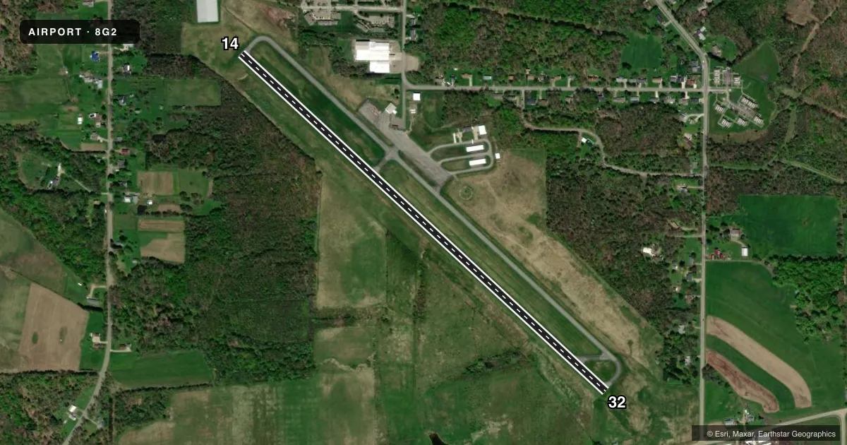
Airport sketch
Runways drawn to scale from FAA survey coordinates, rendered over satellite imagery. Not for navigation.
Approaches & charts
Services on the field
Fuel grades, oxygen, maintenance, ramp storage and lighting — as declared to the FAA by the airport operator.
Fuel & services
- Fuel
- 100LLA+
- Oxygen (bottled)
- Not available
- Oxygen (bulk)
- Not available
- Airframe repair
- Not available
Ramp & ground
- Transient storage
- Tie-down
- Landing fee
- No fee published
- Customs
- Not available
- Lighting schedule
- SEE RMK
- Beacon schedule
- SS-SR
- Beacon
- White / Green (civil land)(WG)
- Wind indicator
- Lighted
- Segmented circle
- Yes
Fuel & FBOs
Cheapest 100LL and Jet A on the field and nearby. Always confirm with the FBO before taxi.
Airport notes
Surface conditions, obstructions, local procedures, lighting outages and other notes published with each FAA cycle.
General notes
- BIRDS ON & INVOF ARPT.
- FOR APCH/DEP CTC CLEVELAND ARTCC AT 440-774-0227 FM 0000-0600.
- FOR CD CTC BUFFALO APCH AT 716-626-6920, WHEN APCH CLSD CTC CLEVELAND ARTCC AT 440-774-0232.
- ARPT UNATNDD.
Lighting notes
- ACTVT REIL RWYS 14 & 32; MIRL RWY 14/32 - CTAF.
Fuel notes
- 100LL100LL FUEL AVBL 24 HR WITH CREDIT CARD.
Other notes
- AUTOMATED UNICOM.
VFR map & nearby airports
VFR sectional. Tap any ICAO chip to open that airport.
Key facts · 8G2
Answer card- ICAO
- 8G2
- Name
- CORRY-LAWRENCE
- Location
- CORRY, PENNSYLVANIA
- Elevation
- 1,765.6 ft MSL
- Traffic pattern altitude
- 2,765.6 ft MSL (1,000 AGL)
- Control tower
- Non-towered (use CTAF)
- Total runways
- 1
- Longest runway
- 14/32 · 4,101 ft
- Published ILS approaches
- 0
- Published frequencies
- 5
- Magnetic variation
- 10°
- Current flight rules
- LIFR
- Current wind
- 180° at 4 kt
- Favored runway now
- RWY 14
Corry-Lawrence Airport sits in Corry, Pennsylvania. Field elevation is 1,765.6 ft MSL. It has one runway, 14/32, which is 4,101 ft long and paved. There is no control tower. The airport is unattended, so plan to self-brief and verify current conditions before you go. No ILS approaches are published here.
Pattern altitude is not published. Use 1,000 ft AGL for light piston operations unless the current Chart Supplement says otherwise. The published lighting is useful for night work. Runway end identifier lights are on runways 14 and 32. Medium intensity runway lights are on 14/32 and are controlled by CTAF.
Corry-Lawrence Airport has one on-field FBO. Corry-Lawrence Airport carries 100LL, JET A and JET A Prist. 100LL is available 24 hours with credit card. Birds are reported on and near the airport, so keep a sharp lookout on arrival and departure. For approach and departure, Buffalo Approach handles the area during normal hours. For late night operations from 0000 to 0600, contact Cleveland ARTCC. If you need clearance delivery, use Buffalo Approach when open or Cleveland ARTCC when approach is closed.