METAR & TAF E75
E75 does not publish a METAR.
Showing the nearest reporting station: KERI (ERIE INTL/TOM RIDGE FLD) · 6.0 NM away. Conditions at E75 may differ.
METAR · KERI
Observed 05:51Z
KERI 270551Z AUTO 19004KT 9SM CLR 20/17 A2986 RMK AO2 SLP108 T02000167 10244 20200 58005 $
- Wind
- 190° @ 4 kt
- Visibility
- 9 SM
- Temp / Dew
- 20°C / 17°C
- Altimeter
- 29.86 inHg
- Clouds
- CLR
- Density alt
- 1,382 ft
- Ceiling
- Unlimited
- Rules
- VFR
Airport info & contacts
Manager on record, flight service, ARTCC, attendance schedule and pattern altitude — published by the FAA and refreshed every 28 days.
Location
- From city
- 3 NM NW
- VFR sectional
- DETROIT
- ARTCC
- ZOB · CLEVELAND
- NOTAM facility
- AOO
Airport manager
- Name
- DONALD WILLIAMS
- Phone
- 814-397-7974
- Address
- 1146 WEST 35 ST, ERIE PA 16508
Flight service · Hours
- FSS AOO
- ALTOONA1-800-WX-BRIEF
Frequencies
Tap any row to copy the frequency to your clipboard.
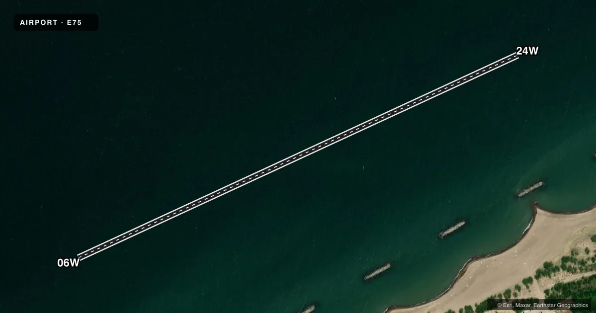
Runways & pattern
Full pagePattern entry · RWY 24W
RIGHT TRAFFICAirport sketch
Runways drawn to scale from FAA survey coordinates, rendered over satellite imagery. Not for navigation.
Approaches & charts
Services on the field
Fuel grades, oxygen, maintenance, ramp storage and lighting — as declared to the FAA by the airport operator.
Fuel & services
- Fuel
- MOGAS
Ramp & ground
- Transient storage
- Not published
Fuel & FBOs
Cheapest 100LL and Jet A on the field and nearby. Always confirm with the FBO before taxi.
Airport notes
Surface conditions, obstructions, local procedures, lighting outages and other notes published with each FAA cycle.
Fuel notes
- MOGASFUEL AVBL APR TO OCT. CLSD DURG WINTER MONTHS.
VFR map & nearby airports
VFR sectional. Tap any ICAO chip to open that airport.
Key facts · E75
Answer card- ICAO
- E75
- Name
- PRESQUE ISLE
- Location
- ERIE, PENNSYLVANIA
- Elevation
- 571 ft MSL
- Traffic pattern altitude
- 1,571 ft MSL (1,000 AGL)
- Control tower
- Non-towered (use CTAF)
- Total runways
- 1
- Longest runway
- 06W/24W · 2,830 ft
- Published ILS approaches
- 0
- Published frequencies
- 1
- Magnetic variation
- –
- Current flight rules
- VFR
- Current wind
- 190° at 4 kt
- Favored runway now
- RWY 24W
Presque Isle (E75) sits in Erie, Pennsylvania at 571 ft MSL. It has one runway. The longest is 06W/24W at 2,830 ft on water. There is no control tower. CTAF is 122.9. No ILS approaches are published here, so plan with that in mind before you go.
The pattern altitude is not published. Use the standard 1,000 ft AGL for light piston operations unless the current Chart Supplement says otherwise. For this field that works out to about 1,571 ft MSL. The runway headings listed are magnetic. This is a water runway, so make sure your aircraft and crew are set up for seaplane operations before arrival.
There are no on-field FBOs listed. Fuel remarks say MOGAS is available from April to October. It is closed during the winter months. If you need current service details before a trip, call the airport operator directly or contact the field on CTAF. For a first-time arrival, the main things to verify are water operations, seasonal fuel availability and any current local procedures in the FAA Chart Supplement.