METAR & TAF KJHW
Current METAR
Observed 05:56Z
KJHW 270556Z AUTO 22003KT 10SM CLR 17/17 A2991 RMK AO2 SLP124 T01720172 10228 20167 58006
- Wind
- 220° @ 3 kt
- Visibility
- 10 SM
- Temp / Dew
- 17°C / 17°C
- Altimeter
- 29.91 inHg
- Clouds
- CLR
- Density alt
- 2,389 ft
- Ceiling
- Unlimited
- Rules
- VFR
Airport info & contacts
Manager on record, flight service, ARTCC, attendance schedule and pattern altitude — published by the FAA and refreshed every 28 days.
Location
- From city
- 3 NM N
- VFR sectional
- DETROIT
- ARTCC
- ZOB · CLEVELAND
- NOTAM facility
- JHW (NOTAM-D)
Airport manager
- Name
- JOHN MACHEMER
- Phone
- 716-581-0062
- Address
- 3163 AIRPORT DR, JAMESTOWN NY 14701
Flight service · Hours
- FSS BUF
- BUFFALO1-800-WX-BRIEF
- Attendance
- M-F · 0600-1430 LCL
Frequencies
Tap any row to copy the frequency to your clipboard.
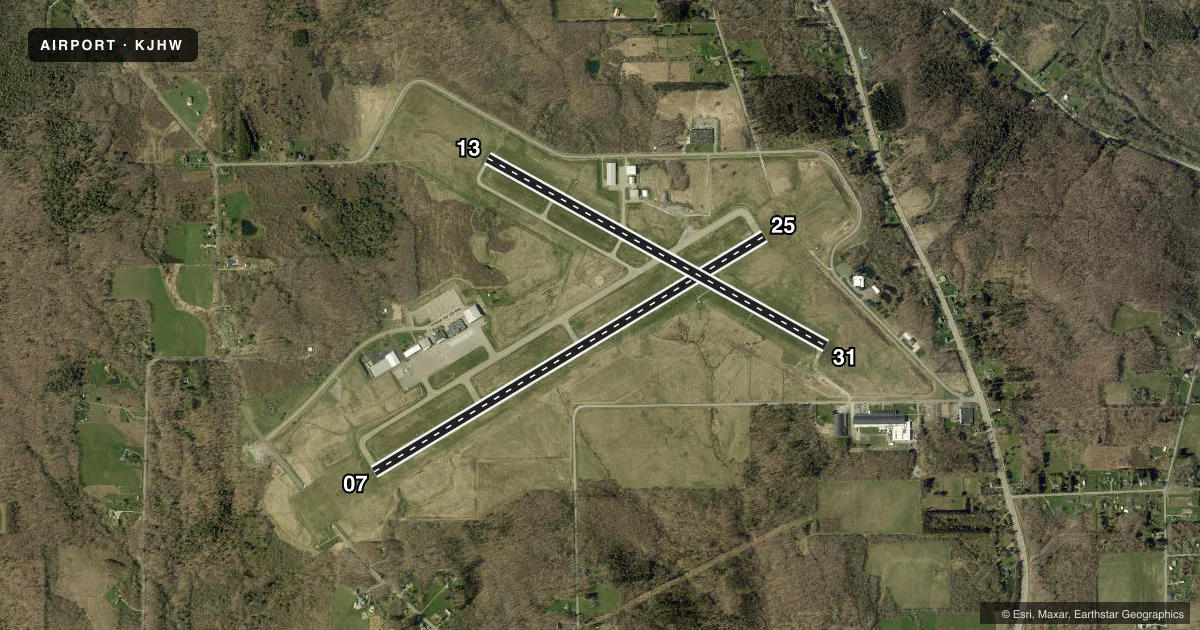
Runways & pattern
Full pagePattern entry · RWY 25
LEFT TRAFFIC| Runway | Heading (°M) | Length | Surface | Traffic |
|---|---|---|---|---|
| 07/25Favored | 49° / 229° | 5,300 ft | ASPH | Standard L |
| 13/31 | 109° / 289° | 4,499 ft | ASPH | Standard L |
Runway end performance
| End | TORA | TODA | ASDA | LDA | VGSI | Approach lights | Obstruction |
|---|---|---|---|---|---|---|---|
| 07 | 5,300' | 5,300' | 5,300' | 5,300' | VASI 4-box left(3°) | — | — |
| 25 | 5,300' | 5,300' | 5,300' | 5,300' | — | MALSR | — |
| 13 | 4,499' | 4,499' | 4,499' | 4,499' | PAPI 4-box left(3°) | — | 69', tree, 1400' from thr, 240' R of cntrln, slope 17 |
| 31 | 4,499' | 4,499' | 4,499' | 4,499' | PAPI 4-box left(3°) | — | 61', bldg, 1200' from thr, 300' R of cntrln, slope 16 |
Declared distances in feet. TORA = takeoff run available, TODA = takeoff distance, ASDA = accelerate-stop, LDA = landing distance.
Airport sketch
Runways drawn to scale from FAA survey coordinates, rendered over satellite imagery. Not for navigation.
Approaches & charts
ILS · 1
Services on the field
Fuel grades, oxygen, maintenance, ramp storage and lighting — as declared to the FAA by the airport operator.
Fuel & services
- Fuel
- 100LLA
- Oxygen (bottled)
- Not available
- Oxygen (bulk)
- HIGH/LOW
- Airframe repair
- Major
- Power plant repair
- Major
- Other services
- AFRT,INSTR,RNTL,SALES
Ramp & ground
- Transient storage
- Tie-down
- Hangar
- Landing fee
- Yes
- Customs
- Not available
- Lighting schedule
- SEE RMK
- Beacon schedule
- SS-SR
- Beacon
- White / Green (civil land)(WG)
- Wind indicator
- Lighted
- Segmented circle
- Yes
Fuel & FBOs
Cheapest 100LL and Jet A on the field and nearby. Always confirm with the FBO before taxi.
Airport notes
Surface conditions, obstructions, local procedures, lighting outages and other notes published with each FAA cycle.
General notes
- DEER AND BIRDS ON & INVOF ARPT.
- SNOW REMOVAL OPS AVBL DURING NORMAL ATTENDANCE HRS; SNOW REMOVAL MAY BE LIMITED ON HOLIDAYS & WEEKENDS.
- FOR CD CTC BUFFALO APCH AT 716-626-6920, WHEN APCH CLSD CTC CLEVELAND ARTCC AT 440-774-0232.
- ATTENDANCE HRS AND SERVICES AVAILABLE ARE SUBJECT TO CHANGE, CALL AIRPORT MANAGER AT 716-484-0204 TO CONFIRM.
- RWY/TWY CONDITIONS NOT MONITORED OUTSIDE OF NORMAL ATTENDANCE HRS.
- 24 HR PPR FOR AIR CARRIER OPS WITH MORE THAN 9 PAX SEATS. CONTACT ARPT MGR AT 716-484-0204. FOR EMERGENCIES AFTER HRS, CALL 911 FOR MUTUAL AID SERVICE.
- ARFF INDEX B CPBL.
Lighting notes
- ACTVT MALSR RWY 25; REIL RWY 31; PAPI RWY 13 & 31; VASI RWY 07; HIRL RWY 07/25; MIRL RWY 13/31 & TWY LGTS - CTAF.
Runway surface & condition
- 07/25PCR VALUE: 250/F/B/W/T
- 13/31PCR VALUE: 148/F/C/W/T
Other notes
- EXISTED PRIOR TO 1959.
- LNDG FEE MULTI-ENGINE ACFT ONLY.
VFR map & nearby airports
VFR sectional. Tap any ICAO chip to open that airport.
Key facts · KJHW
Answer card- ICAO
- KJHW
- Name
- CHAUTAUQUA COUNTY/JAMESTOWN
- Location
- JAMESTOWN, NEW YORK
- Elevation
- 1,723.3 ft MSL
- Traffic pattern altitude
- 2,723.3 ft MSL (1,000 AGL)
- Control tower
- Non-towered (use CTAF)
- Total runways
- 2
- Longest runway
- 07/25 · 5,300 ft
- Published ILS approaches
- 1
- Published frequencies
- 3
- Magnetic variation
- 10°
- Current flight rules
- VFR
- Current wind
- 220° at 3 kt
- Favored runway now
- RWY 25
Chautauqua County/Jamestown Airport is in Jamestown, New York. The field elevation is 1,723.3 ft MSL. It has two asphalt runways. The longest is runway 07/25 at 5,300 ft. There is no control tower. Traffic uses CTAF 122.975. Pattern altitude is not published, so use the standard 1,000 ft AGL for light piston operations unless the current Chart Supplement says otherwise.
The airport has one ILS approach to runway 25. Clearance delivery goes through Buffalo Approach at 126.05. When approach is closed, use Cleveland ARTCC for clearance help. Centric Aviation is on the field. It carries 100LL, Jet A and Jet A Prist. The airport remarks also note that runway and taxiway conditions are not monitored outside normal attendance hours. Deer and birds are present on and near the airport. Keep a sharp scan on departure and arrival.
For a first visit, the main things to plan for are the elevation and the weather. Jamestown sits high enough that density altitude can matter on warm days. Snow removal is available during normal attendance hours. It may be limited on holidays and weekends. The airport also has ARFF index B capability. If you are bringing in a multi-engine aircraft, check the published landing fee note before you go.