METAR & TAF N56
N56 does not publish a METAR.
Showing the nearest reporting station: KOLE (CATTARAUGUS COUNTY-OLEAN) · 12.6 NM away. Conditions at N56 may differ.
METAR · KOLE
Observed 13:15Z
KOLE 271315Z AUTO 00000KT 1SM BR OVC002 A2994 RMK AO2 LTG DSNT N
- Wind
- 000° @ 0 kt
- Visibility
- 1 SM
- Temp / Dew
- —
- Altimeter
- 29.94 inHg
- Clouds
- OVC
- Density alt
- —
- Ceiling
- 200 ft AGL
- Rules
- LIFR
Airport info & contacts
Manager on record, flight service, ARTCC, attendance schedule and pattern altitude — published by the FAA and refreshed every 28 days.
Location
- From city
- 1 NM SE
- VFR sectional
- DETROIT
- ARTCC
- ZOB · CLEVELAND
- NOTAM facility
- BUF (NOTAM-D)
Airport manager
- Name
- PAUL CARMICHAEL
- Phone
- 716-307-5832
- Address
- 7544 WELLER RD, ELLICOTTVILLE NY 14731
Flight service · Hours
- FSS BUF
- BUFFALO1-800-WX-BRIEF
- Attendance
- DALGT
Frequencies
Tap any row to copy the frequency to your clipboard.
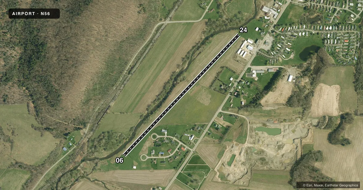
Runways & pattern
Full pagePattern entry · RWY 06
LEFT TRAFFICRunway end performance
| End | TORA | TODA | ASDA | LDA | VGSI | Approach lights | Obstruction |
|---|---|---|---|---|---|---|---|
| 06 | — | — | — | — | — | — | 40', tree, 380' from thr, 105' R of cntrln, slope 9 |
| 24 | — | — | — | — | — | — | 45', tree, 190' from thr, 125' R of cntrln, slope 4 |
Declared distances in feet. TORA = takeoff run available, TODA = takeoff distance, ASDA = accelerate-stop, LDA = landing distance.
Airport sketch
Runways drawn to scale from FAA survey coordinates, rendered over satellite imagery. Not for navigation.
Approaches & charts
Services on the field
Fuel grades, oxygen, maintenance, ramp storage and lighting — as declared to the FAA by the airport operator.
Fuel & services
- Fuel
- Not available
- Airframe repair
- Not available
- Power plant repair
- Not available
Ramp & ground
- Transient storage
- Tie-down
- Landing fee
- No fee published
- Lighting schedule
- SEE RMK
- Wind indicator
- Yes
- Segmented circle
- No
Fuel & FBOs
Cheapest 100LL and Jet A on the field and nearby. Always confirm with the FBO before taxi.
Airport notes
Surface conditions, obstructions, local procedures, lighting outages and other notes published with each FAA cycle.
General notes
- FOR RWY CONDS NOV THRU APR CALL AMGR.
- ARPT DALGT OPS ONLY.
- FOR CD CTC CLEVELAND ARTCC AT 440-774-0227.
- RWY 6/24: 200 FT OVRN S END, 400 FT N END.
Lighting notes
- ACTVT LIRL RWY 06/24 - CTAF.
Runway surface & condition
- 06/24RWY 06/24 LIRL NSTD.
Other notes
- PRVDD IFR OPERATIONS ARE NOT CONDUCTED AND HANGARS TO THE S OF RWY BE OBSTRUCTION LGTD FOR NIGHT OPS.
- MANAGERPAUL CARMICHAEL, ASST MGR 716-307-5832.
VFR map & nearby airports
VFR sectional. Tap any ICAO chip to open that airport.
Key facts · N56
Answer card- ICAO
- N56
- Name
- GREAT VALLEY
- Location
- GREAT VALLEY, NEW YORK
- Elevation
- 1,450 ft MSL
- Traffic pattern altitude
- 2,450 ft MSL (1,000 AGL)
- Control tower
- Non-towered (use CTAF)
- Total runways
- 1
- Longest runway
- 06/24 · 3,200 ft
- Published ILS approaches
- 0
- Published frequencies
- 1
- Magnetic variation
- 10°
- Current flight rules
- LIFR
- Current wind
- 000° at 0 kt
- Favored runway now
- –
Great Valley Airport (N56) is in Great Valley, New York. The field elevation is 1,450 ft MSL. It has one runway. Runway 06/24 is 3,200 ft long with a turf-dirt surface, so plan for soft-field performance and check braking action before you go. There is no control tower. CTAF is 122.9.
No ILS approaches are published here. Pattern altitude is not published, so use the standard 1,000 ft AGL unless the current Chart Supplement says otherwise. This is a daylight operations only airport. The runway has low intensity lighting that is not standard. It is activated via CTAF. Published remarks also note runway overrun areas of 200 ft at the south end and 400 ft at the north end. Hangars south of the runway are lighted for night operations if IFR is not being conducted.
There are no on-field FBOs listed. Contact the airport operator directly before arrival if you need local services. For runway conditions from November through April, call the airport manager. If you need clearance delivery, contact Cleveland ARTCC at 440-774-0227. With a 1,450 ft elevation and a turf-dirt strip, density altitude and surface condition deserve attention, especially on warm days or after wet weather.