METAR & TAF KOLE
Current METAR
Observed 13:15Z
KOLE 271315Z AUTO 00000KT 1SM BR OVC002 A2994 RMK AO2 LTG DSNT N
- Wind
- 000° @ 0 kt
- Visibility
- 1 SM
- Temp / Dew
- —
- Altimeter
- 29.94 inHg
- Clouds
- OVC
- Density alt
- —
- Ceiling
- 200 ft AGL
- Rules
- LIFR
Airport info & contacts
Manager on record, flight service, ARTCC, attendance schedule and pattern altitude — published by the FAA and refreshed every 28 days.
Location
- From city
- 10 NM N
- VFR sectional
- DETROIT
- ARTCC
- ZOB · CLEVELAND
- NOTAM facility
- OLE (NOTAM-D)
Airport manager
- Name
- BRUCE CRANDELL
- Phone
- 716-557-8800
- Address
- AIRPORT ROAD(5420 HATCH HILL RD), HINSDALE NY 14743
Flight service · Hours
- FSS BUF
- BUFFALO1-800-WX-BRIEF
- Attendance
- 0800-1600
Frequencies
Tap any row to copy the frequency to your clipboard.
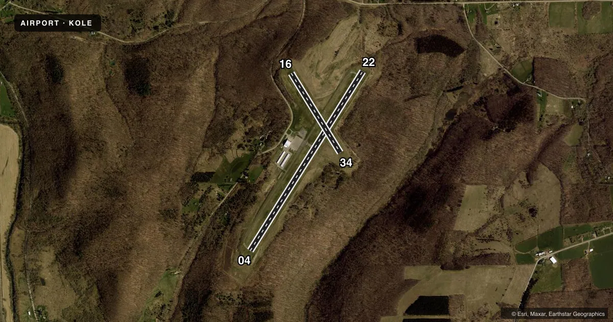
Runways & pattern
Full pagePattern entry · RWY 04
LEFT TRAFFIC| Runway | Heading (°M) | Length | Surface | Traffic |
|---|---|---|---|---|
| 04/22 | 21° / 201° | 4,800 ft | ASPH | Standard L |
| 16/34 | 137° / 317° | 2,117 ft | TURF | Standard L |
Runway end performance
| End | TORA | TODA | ASDA | LDA | VGSI | Approach lights | Obstruction |
|---|---|---|---|---|---|---|---|
| 04 | 4,800' | 4,800' | 4,600' | 4,500' | PAPI 2-box left(3°) | — | 12', trees, 217' from thr, 94' R of cntrln, slope 1 |
| 22 | 4,800' | 4,800' | 4,700' | 4,500' | PAPI 2-box left(3°) | — | 16', trees, 301' from thr, 430' R of cntrln, slope 6 |
| 16 | — | — | — | — | — | — | 24', tree, 253' from thr, 92' R of cntrln, slope 10 |
| 34 | — | — | — | — | — | — | 27', tree, 262' from thr, 151' R of cntrln, slope 9 |
Declared distances in feet. TORA = takeoff run available, TODA = takeoff distance, ASDA = accelerate-stop, LDA = landing distance.
Airport sketch
Runways drawn to scale from FAA survey coordinates, rendered over satellite imagery. Not for navigation.
Approaches & charts
ILS · 1
Services on the field
Fuel grades, oxygen, maintenance, ramp storage and lighting — as declared to the FAA by the airport operator.
Fuel & services
- Fuel
- 100LLA+
- Oxygen (bottled)
- Not available
- Oxygen (bulk)
- Not available
Ramp & ground
- Transient storage
- Tie-down
- Hangar
- Landing fee
- No fee published
- Customs
- Not available
- Lighting schedule
- SEE RMK
- Beacon schedule
- SS-SR
- Beacon
- White / Green (civil land)(WG)
- Wind indicator
- Lighted
- Segmented circle
- No
Fuel & FBOs
Cheapest 100LL and Jet A on the field and nearby. Always confirm with the FBO before taxi.
Airport notes
Surface conditions, obstructions, local procedures, lighting outages and other notes published with each FAA cycle.
General notes
- DEER ON & INVOF ARPT.
- SNOW PLOWING & BRAKING ACTION & FIELD COND RPRTS NOT AVBL WHEN ARPT IS UNATNDD.
- TERRAIN DROPS OFF ON ALL RWY ENDS. RWY 4: 250 FT X 250 FT RESA. RWY 22: 225 FT WIDE X 110 FT LONG RESA.
- RWY 16/34 CLSD WINTER MONTHS; SOFT IN SPRING.
- FUEL AVBL 24/7.
- UNMANNED ACFT 1NM RADIUS SFC-500 FT.
- FOR CD CTC CLEVELAND ARTCC AT 440-774-0227.
Lighting notes
- ACTVT REIL RWY 04 & 22; PAPI RWY 04 & 22; HIRL RWY 04/22; WDI - CTAF.
Approach & departure obstructions
- 0442 TO 52 FT TREES, 0-200 FT FM RWY END, 475 FT RIGHT.
- 225-15 FT TREES, 50-130 FT FM RWY END, 435 FT LEFT.
- 16REFLECTIVE EDGE & THLD MARKINGS.
- 34REFLECTIVE EDGE & THLD MARKINGS.
- 22UNUSBL BYD 5 DEGS LEFT OF CNTRLN.
- 04RWY 04 CLNC SLOPE 6:1 TO DTHR.
- 22RWY 22 CLNC SLOPE 21:1 TO DTHR DUE TO 53 FT TREE, 969 FT. FM RWY END, 585 FT RIGHT.
Other notes
- EXISTED PRIOR TO 1959.
- 1CALL AMGR FOR SVC AVAILABILITY ON HOL.
VFR map & nearby airports
VFR sectional. Tap any ICAO chip to open that airport.
Key facts · KOLE
Answer card- ICAO
- KOLE
- Name
- CATTARAUGUS COUNTY-OLEAN
- Location
- OLEAN, NEW YORK
- Elevation
- 2,135.4 ft MSL
- Traffic pattern altitude
- 3,135.4 ft MSL (1,000 AGL)
- Control tower
- Non-towered (use CTAF)
- Total runways
- 2
- Longest runway
- 04/22 · 4,800 ft
- Published ILS approaches
- 1
- Published frequencies
- 2
- Magnetic variation
- 11°
- Current flight rules
- LIFR
- Current wind
- 000° at 0 kt
- Favored runway now
- –
Cattaraugus County-Olean Airport sits in Olean, New York. Field elevation is 2,135.4 ft MSL. The airport has two runways. The longest is 4,800 ft asphalt runway 04/22. The other runway is 16/34 on turf at 2,117 ft. There is no control tower. CTAF and UNICOM are both 122.8.
Runway 22 has the published ILS approach. Pattern altitude is not published in the facts, so use the standard 1,000 ft AGL for light piston operations unless the current FAA Chart Supplement says otherwise. The on-field FBO is Cattaraugus County-Olean Airport. It carries 100LL and Jet A. Fuel is available 24 hours a day, 7 days a week.
This is a high-elevation field with terrain dropping off on all runway ends. That matters on departure and on short final. Runway 04 has trees near the end of the runway. Runway 22 also has tree and slope notes near the displaced threshold, so review the current Chart Supplement before you go. Deer are present on and near the airport. Unmanned aircraft also operate within 1 NM of the field from the surface to 500 ft AGL. Runway 16/34 is closed during winter months and is soft in spring. Snow plowing, braking action and field condition reports are not available when the airport is unattended.