METAR & TAF KHTF
KHTF does not publish a METAR.
Showing the nearest reporting station: KDSV (DANSVILLE MUNI) · 11.4 NM away. Conditions at KHTF may differ.
METAR · KDSV
Observed 08:39Z
KDSV 270839Z AUTO 12006KT 10SM BKN029 OVC041 18/16 A2986 RMK AO2 T01780161
- Wind
- 120° @ 6 kt
- Visibility
- 10 SM
- Temp / Dew
- 18°C / 16°C
- Altimeter
- 29.86 inHg
- Clouds
- OVC
- Density alt
- 1,946 ft
- Ceiling
- 2,900 ft AGL
- Rules
- MVFR
Airport info & contacts
Manager on record, flight service, ARTCC, attendance schedule and pattern altitude — published by the FAA and refreshed every 28 days.
Location
- From city
- 3 NM N
- VFR sectional
- DETROIT
- Pattern altitude
- 1,000 ft AGL · 2,219 ft MSL
- ARTCC
- ZOB · CLEVELAND
- NOTAM facility
- BUF (NOTAM-D)
Airport manager
- Name
- MITCHELL CORNISH
- Phone
- 607-968-9624
- Address
- 1100 AIRPORT ROAD, HORNELL NY 14843
Flight service · Hours
- FSS BUF
- BUFFALO1-800-WX-BRIEF
- Attendance
- 0800-1600
Frequencies
Tap any row to copy the frequency to your clipboard.
Runways & pattern
Full pagePattern entry · RWY 18
LEFT TRAFFICRunway end performance
| End | TORA | TODA | ASDA | LDA | VGSI | Approach lights | Obstruction |
|---|---|---|---|---|---|---|---|
| 18 | — | — | — | — | — | — | 147', hill, 2129' from thr, 340' R of cntrln, slope 13 |
| 36 | — | — | — | — | PAPI 4-box left(3°) | — | 13', trees, 219' from thr, 182' R of cntrln, slope 1 |
Declared distances in feet. TORA = takeoff run available, TODA = takeoff distance, ASDA = accelerate-stop, LDA = landing distance.
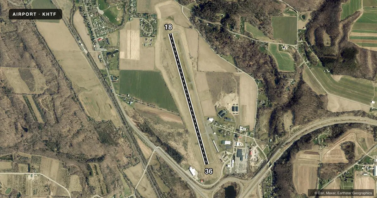
Airport sketch
Runways drawn to scale from FAA survey coordinates, rendered over satellite imagery. Not for navigation.
Approaches & charts
Services on the field
Fuel grades, oxygen, maintenance, ramp storage and lighting — as declared to the FAA by the airport operator.
Fuel & services
- Fuel
- 100LLA
- Oxygen (bottled)
- Not available
- Oxygen (bulk)
- Not available
- Airframe repair
- Not available
- Power plant repair
- Not available
- Other services
- CHTR,INSTR,RNTL
Ramp & ground
- Transient storage
- Tie-down
- Hangar
- Landing fee
- No fee published
- Customs
- Not available
- Lighting schedule
- SEE RMK
- Beacon schedule
- SS-SR
- Beacon
- White / Green (civil land)(WG)
- Wind indicator
- Lighted
- Segmented circle
- Yes
Fuel & FBOs
Cheapest 100LL and Jet A on the field and nearby. Always confirm with the FBO before taxi.
Airport notes
Surface conditions, obstructions, local procedures, lighting outages and other notes published with each FAA cycle.
General notes
- FREQUENT HELICOPTER MEDIVAC OPERATIONS - MONITOR CTAF.
- FOR APCH/DEP CTC CLEVELAND ARTCC AT 440-774-0227.
- FOR CD CTC CLEVELAND ARTCC AT 440-774-0227.
- COLD TEMPERATURE AIRPORT. ALTITUDE CORRECTION REQUIRED AT OR BELOW -18C.
Lighting notes
- ACTVT REIL RWY 18 & 36; MIRL RWY 18/36 - CTAF.
Approach & departure obstructions
- 18REILS RWY 18 OTS INDEFLY.
- 36PAPI UNUSBL BYD 5 DEGS RIGHT & LEFT OF CNTRLN.
- 18RWY 18 CLNC SLOPE 17:1 TO DTHR.
Other notes
- TPA: 1000 FT AGL DALGT, 1200 FT AGL NGT.
- OWNERSHAWN HOGAN, MAYOR
VFR map & nearby airports
VFR sectional. Tap any ICAO chip to open that airport.
Key facts · KHTF
Answer card- ICAO
- KHTF
- Name
- HORNELL MUNI
- Location
- HORNELL, NEW YORK
- Elevation
- 1,219.4 ft MSL
- Traffic pattern altitude
- 2,219.4 ft MSL (1,000 AGL)
- Control tower
- Non-towered (use CTAF)
- Total runways
- 1
- Longest runway
- 18/36 · 5,000 ft
- Published ILS approaches
- 0
- Published frequencies
- 2
- Magnetic variation
- 11°
- Current flight rules
- MVFR
- Current wind
- 120° at 6 kt
- Favored runway now
- RWY 18
Hornell Muni sits in Hornell, New York. Field elevation is 1,219.4 ft MSL. The airport has one runway. Runway 18/36 is 5,000 ft of asphalt. There is no control tower. CTAF and UNICOM are both 122.7.
No ILS approaches are published here. Pattern altitude is 1,000 ft AGL during the day. That works out to 2,219.4 ft MSL. Night pattern altitude is 1,200 ft AGL. For clearance delivery, approach and departure, contact Cleveland ARTCC at 440-774-0227. This field also sees frequent helicopter medevac traffic. Keep a close scan on 122.7.
There are no on-field FBOs listed in the facts. Check with the airport operator or call the field on CTAF for current services before you go. Published remarks also note cold temperature corrections are required at or below minus 18 degrees Celsius. Runway 18 has runway end identifier lights out of service indefinitely. The PAPI for runway 36 is unusable beyond 5 degrees left or right of centerline. Runway 18 has a 17 to 1 clearance slope to the displaced threshold. If you are planning a first stop here, review the current Chart Supplement for any updated local notes before arrival.