METAR & TAF D52
D52 does not publish a METAR.
Showing the nearest reporting station: KDSV (DANSVILLE MUNI) · 15.1 NM away. Conditions at D52 may differ.
METAR · KDSV
Observed 11:54Z
KDSV 271154Z AUTO 13006KT 10SM OVC022 19/16 A2988 RMK AO2 SLP123 T01890161 10189 20172 53007
- Wind
- 130° @ 6 kt
- Visibility
- 10 SM
- Temp / Dew
- 19°C / 16°C
- Altimeter
- 29.88 inHg
- Clouds
- OVC
- Density alt
- 1,224 ft
- Ceiling
- 2,200 ft AGL
- Rules
- MVFR
Airport info & contacts
Manager on record, flight service, ARTCC, attendance schedule and pattern altitude — published by the FAA and refreshed every 28 days.
Location
- From city
- 1 NM W
- VFR sectional
- DETROIT
- ARTCC
- ZOB · CLEVELAND
- NOTAM facility
- BUF (NOTAM-D)
Airport manager
- Name
- AUSTIN WADSWORTH
- Phone
- 585-243-2100
- Address
- 3489 BIG TREE LANE, P.O. BOX 185, GENESEO NY 14454
Flight service · Hours
- FSS BUF
- BUFFALO1-800-WX-BRIEF
- Attendance
- OCT-MAR · WED-SAT · 1000-1500
- APR-SEPT · WED-SUN · 1000-1500
Frequencies
Tap any row to copy the frequency to your clipboard.
Runways & pattern
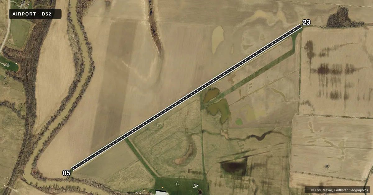
Full pagePattern entry · RWY 05
LEFT TRAFFICRunway end performance
| End | TORA | TODA | ASDA | LDA | VGSI | Approach lights | Obstruction |
|---|---|---|---|---|---|---|---|
| 05 | — | — | — | — | — | — | 105', trees, 215' from thr, 100' R of cntrln, slope 2 |
| 23 | — | — | — | — | — | — | 5', crops, 1' from thr, 72' R of cntrln, slope 0 |
Declared distances in feet. TORA = takeoff run available, TODA = takeoff distance, ASDA = accelerate-stop, LDA = landing distance.
Airport sketch
Runways drawn to scale from FAA survey coordinates, rendered over satellite imagery. Not for navigation.
Approaches & charts
Services on the field
Fuel grades, oxygen, maintenance, ramp storage and lighting — as declared to the FAA by the airport operator.
Fuel & services
- Fuel
- Not available
- Oxygen (bottled)
- Not available
- Oxygen (bulk)
- Not available
- Airframe repair
- Not available
- Power plant repair
- Not available
Ramp & ground
- Transient storage
- Not published
- Landing fee
- No fee published
- Customs
- Not available
- Wind indicator
- Yes
- Segmented circle
- Yes
Fuel & FBOs
Cheapest 100LL and Jet A on the field and nearby. Always confirm with the FBO before taxi.
Airport notes
Surface conditions, obstructions, local procedures, lighting outages and other notes published with each FAA cycle.
General notes
- FREQUENT AG-PLANES IN VCNTY.
- WATCH FOR GEESE AND SEA GULLS.
- TWO LGTD ANT LEFT OF RWY 23 IN VILLAGE OF GENESEO.
- ATNDC REQS FOR OTHER THAN SKED TIMES CALL AMGR.
- RWY 05:+90 TREES, 155 FT FM RWY BEG, 110 FT RIGHT & CONT ACRS CNTRLN AT ANGLE.
- RWY 23: 60-70 FT TREES, 370 FT FM RWY; 100 FT LEFT OF CNTRLN.
- RWY 05:+29 FT PLINE, 38 FT FM RWY; 125 FT RIGHT & CONT ACRS RWY CNTRLN AT ANGLE.
- TURF SOFT AND WET FOR FIRST 1800 FT FM THLD RWY 23 DURG OCT-MAY.
- FOR CD CTC CLEVELAND ARTCC AT 440-774-0490.
Runway surface & condition
- 05/23RWY 23 END IS NOT CLEARLY MKD.
Approach & departure obstructions
- 05RWY 05 END MKD WITH WHITE PAINT AT EDGES & ORANGE CONES ONLY DURG AIRSHOW.
- 23RWY MKD WITH WHITE PAINT AT EDGES ONLY DURG AIRSHOW.
Other notes
- VFR OPNS ONLY.
- OWNERATTN: CRAIG WADSWORTH
VFR map & nearby airports
VFR sectional. Tap any ICAO chip to open that airport.
Key facts · D52
Answer card- ICAO
- D52
- Name
- GENESEO
- Location
- GENESEO, NEW YORK
- Elevation
- 560 ft MSL
- Traffic pattern altitude
- 1,560 ft MSL (1,000 AGL)
- Control tower
- Non-towered (use CTAF)
- Total runways
- 1
- Longest runway
- 05/23 · 5,000 ft
- Published ILS approaches
- 0
- Published frequencies
- 1
- Magnetic variation
- 11°
- Current flight rules
- MVFR
- Current wind
- 130° at 6 kt
- Favored runway now
- RWY 05
Geneseo Airport (D52) sits in Geneseo, New York. Field elevation is 560 ft MSL. The airport has one runway. Runway 05/23 is 5,000 ft of turf, which is the longest runway on the field. There is no control tower. CTAF is 122.9.
No ILS approaches are published here. The published pattern altitude is not listed, so use the standard 1,000 ft AGL for light piston operations unless the current FAA Chart Supplement says otherwise. This is a VFR-only field, so plan accordingly. The runway environment has a few things worth studying before arrival. Runway 05 has a power line near the approach end. It also has tall trees close to the runway. Runway 23 has 60 to 70 ft trees left of centerline. The 23 end is not clearly marked. The turf can be soft and wet for the first 1,800 ft from runway 23 during October through May.
There are no on-field FBOs listed. Attendance is required outside scheduled times. Call the airport manager before you go. Frequent ag operations are reported in the area. Watch for geese and sea gulls. For clearance delivery, contact Cleveland ARTCC at 440-774-0490.