METAR & TAF 5G0
5G0 does not publish a METAR.
Showing the nearest reporting station: KGVQ (GENESEE COUNTY) · 10.7 NM away. Conditions at 5G0 may differ.
METAR · KGVQ
Observed 10:56Z
KGVQ 271056Z AUTO 23003KT 9SM FEW012 19/17 A2986 RMK AO2 SLP105 T01890172
- Wind
- 230° @ 3 kt
- Visibility
- 9 SM
- Temp / Dew
- 19°C / 17°C
- Altimeter
- 29.86 inHg
- Clouds
- FEW
- Density alt
- 1,522 ft
- Ceiling
- Unlimited
- Rules
- VFR
Airport info & contacts
Manager on record, flight service, ARTCC, attendance schedule and pattern altitude — published by the FAA and refreshed every 28 days.
Location
- From city
- 2 NM E
- VFR sectional
- DETROIT
- ARTCC
- ZOB · CLEVELAND
- NOTAM facility
- BUF (NOTAM-D)
Airport manager
- Name
- RAY DETOR
- Phone
- 585-259-9308
- Address
- 283 WESTMINSTER ROAD, ROCHESTER NY 14607-3229
Flight service · Hours
- FSS BUF
- BUFFALO1-800-WX-BRIEF
- Attendance
- MON-FRI · 1000-1600
Frequencies
Tap any row to copy the frequency to your clipboard.
Runways & pattern
Full pagePattern entry · RWY 28
LEFT TRAFFICRunway end performance
| End | TORA | TODA | ASDA | LDA | VGSI | Approach lights | Obstruction |
|---|---|---|---|---|---|---|---|
| 10 | — | — | — | — | PAPI 2-box left(3°) | — | 40', tree, 214' from thr, 220' R of cntrln, slope 0 |
| 28 | — | — | — | — | PAPI 2-box left(3.5°) | — | 8', fence, 201' from thr, 100' R of cntrln, slope 0 |
Declared distances in feet. TORA = takeoff run available, TODA = takeoff distance, ASDA = accelerate-stop, LDA = landing distance.
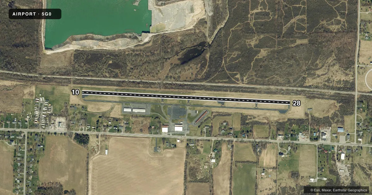
Airport sketch
Runways drawn to scale from FAA survey coordinates, rendered over satellite imagery. Not for navigation.
Approaches & charts
Services on the field
Fuel grades, oxygen, maintenance, ramp storage and lighting — as declared to the FAA by the airport operator.
Fuel & services
- Fuel
- 100LL
- Oxygen (bottled)
- Not available
- Oxygen (bulk)
- Not available
- Airframe repair
- Minor
- Power plant repair
- Minor
- Other services
- INSTR,RNTL,SALES
Ramp & ground
- Transient storage
- Tie-down
- Hangar
- Landing fee
- No fee published
- Customs
- Not available
- Lighting schedule
- SEE RMK
- Beacon schedule
- SS-SR
- Beacon
- White / Green (civil land)(WG)
- Wind indicator
- Lighted
- Segmented circle
- No
Fuel & FBOs
Cheapest 100LL and Jet A on the field and nearby. Always confirm with the FBO before taxi.
Airport notes
Surface conditions, obstructions, local procedures, lighting outages and other notes published with each FAA cycle.
General notes
- DEER ON AND INVOF ARPT.
- FOR CD CTC CLEVELAND ARTCC AT 440-774-0490.
Lighting notes
- SS-SR, ACTVT REIL RWY 10 & 28; PAPI RWY 10 & 28; MIRL RWY 10/28 - CTAF.
Approach & departure obstructions
- 108 FT FENCE; 0-199 FT DSTC, 94 FT LEFT.
- 288 FT FENCE; 0-199 FT DSTC, 100 FT RIGHT.
- 1030 FT TREES; 320 FT DTSC, 100 FT RIGHT.
Other notes
- IN ACCORD WITH VFR.
- 2EXCP MAJOR HOL.
VFR map & nearby airports
VFR sectional. Tap any ICAO chip to open that airport.
Key facts · 5G0
Answer card- ICAO
- 5G0
- Name
- LE ROY
- Location
- LE ROY, NEW YORK
- Elevation
- 780.3 ft MSL
- Traffic pattern altitude
- 1,780.3 ft MSL (1,000 AGL)
- Control tower
- Non-towered (use CTAF)
- Total runways
- 1
- Longest runway
- 10/28 · 3,854 ft
- Published ILS approaches
- 0
- Published frequencies
- 4
- Magnetic variation
- 11°
- Current flight rules
- VFR
- Current wind
- 230° at 3 kt
- Favored runway now
- RWY 28
Le Roy Airport sits in Le Roy, New York. The field elevation is 780.3 ft MSL. It has one runway, 10/28, which is 3,854 ft long and paved with asphalt. There is no control tower. Traffic uses CTAF 122.8. The published pattern altitude is not listed, so use the standard 1,000 ft AGL for light piston traffic unless the current FAA Chart Supplement says otherwise.
No ILS approaches are published here. The airport uses the Rochester approach and departure frequencies when you need ATC help. LeRoy Aviation Services is on the field. It carries 100LL. The airport is attended daily except major holidays.
A few runway notes matter here. There is an 8-foot fence near runway 28. It sits close to the runway and off to the right. Runway 10 has 30-foot trees off the right side. It also has an 8-foot fence off the left side. Deer are reported on and near the airport. Keep a sharp scan on taxi, takeoff and landing. From sunset to sunrise, the runway end identifier lights, PAPI and medium intensity runway lights are available on 10/28. This is a VFR field. Plan with that in mind. If you need clearance delivery, contact Cleveland ARTCC at the published phone number before departure.