METAR & TAF KIUA
Current METAR
Observed 13:35Z
KIUA 271335Z AUTO 27005KT 10SM CLR 24/19 A2986 RMK AO2 T02370188
- Wind
- 270° @ 5 kt
- Visibility
- 10 SM
- Temp / Dew
- 24°C / 19°C
- Altimeter
- 29.86 inHg
- Clouds
- CLR
- Density alt
- 2,163 ft
- Ceiling
- Unlimited
- Rules
- VFR
Airport info & contacts
Manager on record, flight service, ARTCC, attendance schedule and pattern altitude — published by the FAA and refreshed every 28 days.
Location
- From city
- 3 NM NW
- VFR sectional
- DETROIT
- ARTCC
- ZOB · CLEVELAND
- NOTAM facility
- BUF (NOTAM-D)
Airport manager
- Name
- BOB MINCER
- Phone
- 585-919-2772
- Address
- 20 ONTARIO ST, C/O ONTARIO COUNTY IDA, CANANDAIGUA NY 14425
Flight service · Hours
- FSS BUF
- BUFFALO1-800-WX-BRIEF
- Attendance
- ALL
Frequencies
Tap any row to copy the frequency to your clipboard.
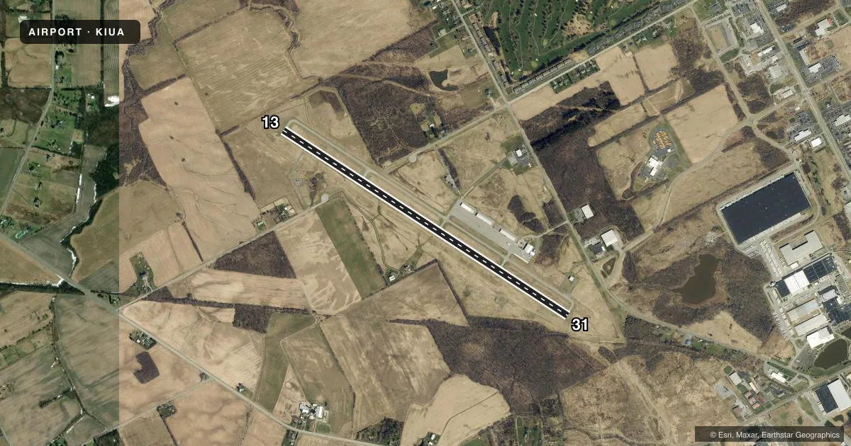
Runways & pattern
Full pagePattern entry · RWY 31
LEFT TRAFFICRunway end performance
| End | TORA | TODA | ASDA | LDA | VGSI | Approach lights | Obstruction |
|---|---|---|---|---|---|---|---|
| 13 | — | — | — | — | PAPI 2-box left(3°) | — | 32', tree, 1331' from thr, 187' R of cntrln, slope 35 |
| 31 | — | — | — | — | PAPI 2-box right(3°) | — | 38', tree, 1069' from thr, 131' R of cntrln, slope 22 |
Declared distances in feet. TORA = takeoff run available, TODA = takeoff distance, ASDA = accelerate-stop, LDA = landing distance.
Airport sketch
Runways drawn to scale from FAA survey coordinates, rendered over satellite imagery. Not for navigation.
Approaches & charts
Services on the field
Fuel grades, oxygen, maintenance, ramp storage and lighting — as declared to the FAA by the airport operator.
Fuel & services
- Fuel
- 100LLA+
- Oxygen (bottled)
- Not available
- Oxygen (bulk)
- Not available
- Airframe repair
- Major
- Power plant repair
- Major
- Other services
- INSTR,RNTL
Ramp & ground
- Transient storage
- Tie-down
- Hangar
- Landing fee
- No fee published
- Customs
- Not available
- Lighting schedule
- SEE RMK
- Beacon schedule
- SS-SR
- Beacon
- White / Green (civil land)(WG)
- Wind indicator
- Lighted
- Segmented circle
- Yes
Fuel & FBOs
Cheapest 100LL and Jet A on the field and nearby. Always confirm with the FBO before taxi.
Airport notes
Surface conditions, obstructions, local procedures, lighting outages and other notes published with each FAA cycle.
General notes
- FOR SVCS AND ARPT CONDS CALL 585-394-4780.
- FQT MEDIVAC HEL OPNS: MNT CTAF.
- FOR CD CTC CLEVELAND ARTCC AT 440-774-0490.
Lighting notes
- ACTVT REIL RWY 13 & 31; PAPI RWY 13 & 31; MIRL RWY 13/31 - CTAF.
Approach & departure obstructions
- 319 FT BUSH AND FENCE 176 FT FM THR, 243 FT LEFT.
Other notes
- EXISTED PRIOR TO 1959.
- 17AM-5PM DLY, CALL FBO FOR AFT HRS SVC.
VFR map & nearby airports
VFR sectional. Tap any ICAO chip to open that airport.
Key facts · KIUA
Answer card- ICAO
- KIUA
- Name
- CANANDAIGUA
- Location
- CANANDAIGUA, NEW YORK
- Elevation
- 813.6 ft MSL
- Traffic pattern altitude
- 1,813.6 ft MSL (1,000 AGL)
- Control tower
- Non-towered (use CTAF)
- Total runways
- 1
- Longest runway
- 13/31 · 5,500 ft
- Published ILS approaches
- 0
- Published frequencies
- 4
- Magnetic variation
- 12°
- Current flight rules
- VFR
- Current wind
- 270° at 5 kt
- Favored runway now
- RWY 31
Canandaigua Airport (KIUA) sits in Canandaigua, New York. The field elevation is 813.6 ft MSL. It has one runway, 13/31, which is 5,500 ft long and asphalt. There is no control tower. The airport uses CTAF 122.8. Rochester Approach and Departure are on 119.55 and 269.6.
No ILS approaches are published here. Pattern altitude is not published, so use the standard 1,000 ft AGL for light piston traffic unless the current Chart Supplement says otherwise. The published lighting setup is useful at night. Runway end identifier lights are installed on 13 and 31. Precision approach path indicators are installed on both ends. Medium intensity runway lights are on runway 13/31. They are controlled by CTAF.
VAS Operations is on the field. It carries 100LL, Jet A and Jet A Prist. Airport services are listed daily from 7 AM to 5 PM. Call the FBO directly for after-hours service or current conditions. The remarks also note frequent medivac helicopter traffic, so keep a sharp scan on CTAF. There is also a reported 9-foot bush and fence near the threshold on runway 31, offset to the left. For clearance delivery, contact Cleveland ARTCC at 440-774-0490. If you need current airport conditions, call 585-394-4780 before you go.