METAR & TAF 92G
92G does not publish a METAR.
Showing the nearest reporting station: KIUA (CANANDAIGUA) · 7.8 NM away. Conditions at 92G may differ.
METAR · KIUA
Observed 12:35Z
KIUA 271235Z AUTO 26004KT 10SM CLR 22/18 A2986 RMK AO2 T02160183
- Wind
- 260° @ 4 kt
- Visibility
- 10 SM
- Temp / Dew
- 22°C / 18°C
- Altimeter
- 29.86 inHg
- Clouds
- CLR
- Density alt
- 2,254 ft
- Ceiling
- Unlimited
- Rules
- VFR
Airport info & contacts
Manager on record, flight service, ARTCC, attendance schedule and pattern altitude — published by the FAA and refreshed every 28 days.
Location
- From city
- 3 NM W
- VFR sectional
- DETROIT
- ARTCC
- ZOB · CLEVELAND
- NOTAM facility
- BUF (NOTAM-D)
Airport manager
- Name
- J TRAVIS YATES
- Phone
- 585-764-1802
- Address
- 3730 LAKE TO LAKE ROAD, STANLEY NY 14561
Flight service · Hours
- FSS BUF
- BUFFALO1-800-WX-BRIEF
- Attendance
- MON-FRI · IRREG
- SAT-SUN · IRREG
Frequencies
Tap any row to copy the frequency to your clipboard.
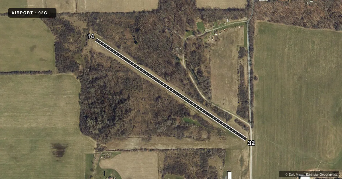
Runways & pattern
Full pagePattern entry · RWY 32
LEFT TRAFFICRunway end performance
| End | TORA | TODA | ASDA | LDA | VGSI | Approach lights | Obstruction |
|---|---|---|---|---|---|---|---|
| 14 | — | — | — | — | — | — | 18', trees, 41' from thr, 69' R of cntrln, slope 2 |
| 32 | — | — | — | — | — | — | 78', road, 801' from thr, 0' R of cntrln, slope 10 |
Declared distances in feet. TORA = takeoff run available, TODA = takeoff distance, ASDA = accelerate-stop, LDA = landing distance.
Airport sketch
Runways drawn to scale from FAA survey coordinates, rendered over satellite imagery. Not for navigation.
Approaches & charts
Services on the field
Fuel grades, oxygen, maintenance, ramp storage and lighting — as declared to the FAA by the airport operator.
Fuel & services
- Fuel
- Not available
Ramp & ground
- Transient storage
- Tie-down
- Landing fee
- No fee published
- Wind indicator
- Yes
- Segmented circle
- No
Fuel & FBOs
Cheapest 100LL and Jet A on the field and nearby. Always confirm with the FBO before taxi.
Airport notes
Surface conditions, obstructions, local procedures, lighting outages and other notes published with each FAA cycle.
General notes
- RY 14/32 SOFT & WET DURG MAR-JUN.
- RY 32 HAS +80 FT TREES 735 FT FM THLD +80 FT L/R OF CNTRLN.
- FOR CD CTC CLEVELAND ARTCC AT 440-774-0490.
Approach & departure obstructions
- 14RY 14/32 MRKD WITH ORANGE CONES.
- 14MARKED POWER POLES 2700 FT FROM THLD; +20 FT BRUSH 50 FT FROM THLD BOTH SIDES OF CNTRLN; +57 FT TREE 710 FT FROM THLD 177 FT R.
- 32POWER POLES MARKED 1300 FT FM THLD. TREES 735 FT FM THLD+80' L/R OF CENTERLINE.
Other notes
- VFR USE ONLY.
VFR map & nearby airports
VFR sectional. Tap any ICAO chip to open that airport.
Key facts · 92G
Answer card- ICAO
- 92G
- Name
- MIDLAKES
- Location
- GORHAM, NEW YORK
- Elevation
- 1,080 ft MSL
- Traffic pattern altitude
- 2,080 ft MSL (1,000 AGL)
- Control tower
- Non-towered (use CTAF)
- Total runways
- 1
- Longest runway
- 14/32 · 1,820 ft
- Published ILS approaches
- 0
- Published frequencies
- 2
- Magnetic variation
- 11°
- Current flight rules
- VFR
- Current wind
- 260° at 4 kt
- Favored runway now
- RWY 32
MIDLAKES (92G) sits in Gorham, New York at 1,080 ft MSL. It has one runway. Runway 14/32 is 1,820 ft of turf, with magnetic headings of 124° and 304°. This is a non-towered field. CTAF and UNICOM are both 122.8. No ILS approaches are published here.
The pattern altitude is not published. Use the standard 1,000 ft AGL pattern unless the current Chart Supplement or local guidance says otherwise. For a light piston, that puts you at about 2,080 ft MSL. The field is VFR only. That matters here because the runway is short and turf. Plan for a conservative performance margin.
Published remarks call out several obstructions near both ends. Runway 14 has marked power poles, brush close to the threshold and a tall tree off the right side. Runway 32 has power poles and trees near the approach end. Both runways are marked with orange cones. The Chart Supplement also notes soft and wet runway conditions from March through June. If you need clearance delivery, contact Cleveland ARTCC at 440-774-0490. There are no on-field FBOs listed, so verify services with the airport operator or the field directly before you go.