METAR & TAF 0G7
0G7 does not publish a METAR.
Showing the nearest reporting station: KPEO (PENN YAN/YATES COUNTY) · 19.0 NM away. Conditions at 0G7 may differ.
METAR · KPEO
Observed 05:53Z
KPEO 270553Z AUTO 00000KT 8SM CLR 18/18 A2987 RMK AO2 SLP107 T01830178 10239 20178 56005
- Wind
- 000° @ 0 kt
- Visibility
- 8 SM
- Temp / Dew
- 18°C / 18°C
- Altimeter
- 29.87 inHg
- Clouds
- CLR
- Density alt
- 1,032 ft
- Ceiling
- Unlimited
- Rules
- VFR
Airport info & contacts
Manager on record, flight service, ARTCC, attendance schedule and pattern altitude — published by the FAA and refreshed every 28 days.
Location
- From city
- 2 NM SE
- VFR sectional
- NEW YORK
- ARTCC
- ZBW · BOSTON
- NOTAM facility
- BUF (NOTAM-D)
Airport manager
- Name
- DAVID HAIMES
- Phone
- 315-539-1640
- Address
- 2727 MARTIN RD, SENECA FALLS NY 13148
Flight service · Hours
- FSS BUF
- BUFFALO1-800-WX-BRIEF
- Attendance
- 0800-1600
Frequencies
Tap any row to copy the frequency to your clipboard.
Runways & pattern
Full pagePattern entry · RWY 01
LEFT TRAFFIC| Runway | Heading (°M) | Length | Surface | Traffic |
|---|---|---|---|---|
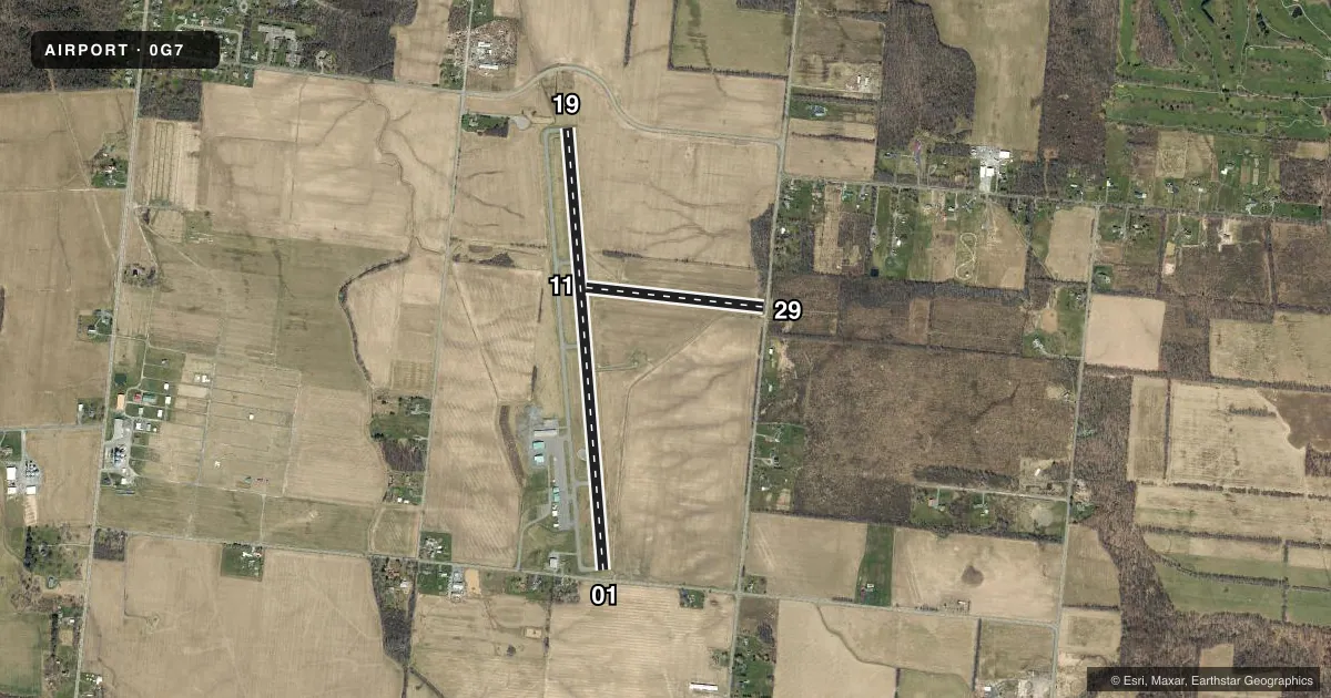
| 01/19 | 343° / 163° | 4,592 ft | ASPH | Standard L |
| 11/29 | 84° / 264° | 1,850 ft | TURF | Standard L |
Runway end performance
| End | TORA | TODA | ASDA | LDA | VGSI | Approach lights | Obstruction |
|---|---|---|---|---|---|---|---|
| 01 | 4,592' | 4,592' | 4,592' | 4,199' | PAPI 2-box left(3°) | — | 35', trees, 404' from thr, 243' R of cntrln, slope 5 |
| 19 | 4,592' | 4,592' | 4,592' | 4,292' | PAPI 2-box left(3°) | — | 4', crops, 201' from thr, 112' R of cntrln, slope 0 |
| 11 | — | — | — | — | — | — | 33', trees, 457' from thr, 81' R of cntrln, slope 13 |
| 29 | — | — | — | — | — | — | 53', trees, 74' from thr, 82' R of cntrln, slope 1 |
Declared distances in feet. TORA = takeoff run available, TODA = takeoff distance, ASDA = accelerate-stop, LDA = landing distance.
Airport sketch
Runways drawn to scale from FAA survey coordinates, rendered over satellite imagery. Not for navigation.
Approaches & charts
Services on the field
Fuel grades, oxygen, maintenance, ramp storage and lighting — as declared to the FAA by the airport operator.
Fuel & services
- Fuel
- 100LLA
- Oxygen (bottled)
- Not available
- Oxygen (bulk)
- Not available
- Airframe repair
- Major
- Power plant repair
- Major
- Other services
- AFRT,AVNCS,CHTR,INSTR
Ramp & ground
- Transient storage
- Tie-down
- Hangar
- Landing fee
- Yes
- Customs
- Not available
- Lighting schedule
- SEE RMK
- Beacon schedule
- SS-SR
- Beacon
- White / Green (civil land)(WG)
- Wind indicator
- Lighted
- Segmented circle
- Yes
Fuel & FBOs
Cheapest 100LL and Jet A on the field and nearby. Always confirm with the FBO before taxi.
Airport notes
Surface conditions, obstructions, local procedures, lighting outages and other notes published with each FAA cycle.
General notes
- MEDIVAC HEL FLT SERVICE ON ARPT; MONITOR CTAF FOR OPS.
- FOR CD CTC SYRACUSE APCH AT 315-455-6218.
Lighting notes
- ACTVT REIL RWY 01 & 19; MIRL RWY 01/19 - CTAF.
Approach & departure obstructions
- 01RWY 01 HAS 15 FT ROAD 90 FT FM RWY PERPENDICULAR TO RWY; 2 FT BERM, PARL TO RWY, 99 FT RIGHT.
- 194 FT CROPS, AT THLD, 111 FT LEFT.
- 01RWY 01 CLNC SLOPE 15:1 TO DTHR.
- 11RWY 29 HAS 17 FT ROAD 30 FT FM RWY THLD, PERPENDICULAR TO RWY.
Other notes
- EXISTED PRIOR TO 1959.
- LANDING FEE FOR JETS AND TURBO PROPS.
VFR map & nearby airports
VFR sectional. Tap any ICAO chip to open that airport.
Key facts · 0G7
Answer card- ICAO
- 0G7
- Name
- FINGER LAKES RGNL
- Location
- SENECA FALLS, NEW YORK
- Elevation
- 491.8 ft MSL
- Traffic pattern altitude
- 1,491.8 ft MSL (1,000 AGL)
- Control tower
- Non-towered (use CTAF)
- Total runways
- 2
- Longest runway
- 01/19 · 4,592 ft
- Published ILS approaches
- 0
- Published frequencies
- 8
- Magnetic variation
- 12°
- Current flight rules
- VFR
- Current wind
- 000° at 0 kt
- Favored runway now
- –
Finger Lakes Rgnl Airport (0G7) sits in Seneca Falls, New York. Field elevation is 491.8 ft MSL. The airport has 2 runways. The longest is 4,592 ft of asphalt on 01/19. Runway 11/29 is 1,850 ft of turf. There is no control tower. CTAF and UNICOM are both 122.8. No ILS approaches are published here.
Pattern altitude is not published. Use 1,000 ft AGL for light piston traffic unless the current FAA Chart Supplement says otherwise. That puts the standard pattern around 1,492 ft MSL based on the field elevation. The on-field FBO is Finger Lakes Regional Airport. It carries 100LL, Jet A and Jet A Prist. Call (315) 568-0110 for current services before you go.
A few published remarks matter here. Runway 01 has terrain and road issues near the approach end, so brief that side carefully. Runway 19 has crops near the threshold. Runway 01 and 19 have medium intensity lights with REILs. The lights are controlled on CTAF. Medical helicopter ops also use the field, so keep a sharp scan on the common frequency. Jets and turboprops should expect a landing fee. For clearance delivery, contact Syracuse Approach. This is a non-towered field with nearby approach control traffic, so plan your calls early and stay ahead of the frequency.