METAR & TAF 6B9
Current METAR
Observed 12:55Z
K6B9 271255Z AUTO 23003KT 10SM FEW120 21/18 A2987 RMK AO2
- Wind
- 230° @ 3 kt
- Visibility
- 10 SM
- Temp / Dew
- 21°C / 18°C
- Altimeter
- 29.87 inHg
- Clouds
- FEW
- Density alt
- 2,070 ft
- Ceiling
- Unlimited
- Rules
- VFR
Airport info & contacts
Manager on record, flight service, ARTCC, attendance schedule and pattern altitude — published by the FAA and refreshed every 28 days.
Location
- From city
- 2 NM SW
- VFR sectional
- NEW YORK
- Pattern altitude
- 800 ft AGL · 1,839 ft MSL
- ARTCC
- ZBW · BOSTON
- NOTAM facility
- BUF (NOTAM-D)
Airport manager
- Name
- DANIEL ARNOLD
- Phone
- 707-580-9240
- Address
- 2984 BENSON ROAD, SKANEATELES NY 13152
Flight service · Hours
- FSS BUF
- BUFFALO1-800-WX-BRIEF
- Attendance
- Unattended; CALL MGR
Frequencies
Tap any row to copy the frequency to your clipboard.
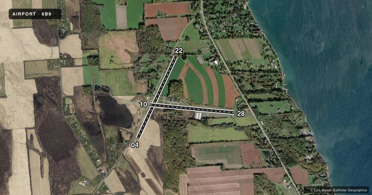
Runways & pattern
Full pagePattern entry · RWY 22
LEFT TRAFFIC| Runway | Heading (°M) | Length | Surface | Traffic |
|---|---|---|---|---|
| 04/22Favored | 13° / 193° | 3,350 ft | TURF | Standard L |
| 10/28 | 83° / 263° | 3,134 ft | ASPH | Standard L |
Runway end performance
| End | TORA | TODA | ASDA | LDA | VGSI | Approach lights | Obstruction |
|---|---|---|---|---|---|---|---|
| 04 | — | — | — | — | — | — | 37', trees, 56' from thr, 80' R of cntrln, slope 1 |
| 22 | — | — | — | — | — | — | 30', fence, 69' from thr, 82' R of cntrln, slope 2 |
| 10 | — | — | — | — | — | — | 59', trees, 440' from thr, 78' R of cntrln, slope 4 |
| 28 | — | — | — | — | — | — | 51', trees, 265' from thr, 113' R of cntrln, slope 1 |
Declared distances in feet. TORA = takeoff run available, TODA = takeoff distance, ASDA = accelerate-stop, LDA = landing distance.
Airport sketch
Runways drawn to scale from FAA survey coordinates, rendered over satellite imagery. Not for navigation.
Approaches & charts
Services on the field
Fuel grades, oxygen, maintenance, ramp storage and lighting — as declared to the FAA by the airport operator.
Fuel & services
- Fuel
- 100LL
- Oxygen (bottled)
- Not available
- Oxygen (bulk)
- Not available
Ramp & ground
- Transient storage
- Tie-down
- Hangar
- Landing fee
- No fee published
- Customs
- Not available
- Lighting schedule
- SEE RMK
- Wind indicator
- Lighted
- Segmented circle
- No
Fuel & FBOs
Cheapest 100LL and Jet A on the field and nearby. Always confirm with the FBO before taxi.
Airport notes
Surface conditions, obstructions, local procedures, lighting outages and other notes published with each FAA cycle.
General notes
- RWY 04/22 AVBL 15 MAY TO 15 OCT.
- RY 28 TWO 55 FT POWER POLES 70 FT EITHER SIDE OF CNTRLN 700 FM THRESHOLD.
- RY 10 3 FT FENCE 20 FT FM THLD ON BOTH SIDES 15 FT ROAD 30 FT FM THLD ON BOTH SIDES & 4 FT FENCE 80 FT FM THLD ON BOTH SIDES. -10 FT CULVERT/DITCH 50 FT LEFT OF CNTRLNE AT THRESHOLD.
- FUEL AVBL 24 HRS SELF SER CREDIT CARD.
- FOR CD CTC SYRACUSE APCH AT 315-455-6218.
Lighting notes
- ACTVT MIRL RWY 10/28 - CTAF.
Runway surface & condition
- 10/28RWY 10/28 NSTD MIRL; LGTS ARE 38 FT FM PAVEMENT EDGE.
Approach & departure obstructions
- 10RWY 10 TWO 30 FT PWR POLES 80 FT EITHER SIDE OF CNTRLN 60 FT FM THLD; 3 FT FENCE OB 20 FT FM THLD 15 FT ROAD OB 30 FT FM THLD. 4 FT FENCE OB 80 FT FM THLD.
- 28RWY 28 33 FT TREE 138 FT FM RWY 120 FT RIGHT; 10 FT FARM ROAD CROSSES APPROACH END 117 FT FM THR.
- 04RWY 22 FENCE CROSSES RWY 10 FT FM THR BLO RWY ELEV.
Other notes
- THIS AIRPORT HAS BEEN SURVEYED BY THE NATIONAL GEODETIC SURVEY.
- OWNERWEBSITE ADDRESS: WWW.SKANEATELESAERODROME.COM
- 04/22HAS VARIATIONS IN RWY SFC.
VFR map & nearby airports
VFR sectional. Tap any ICAO chip to open that airport.
Key facts · 6B9
Answer card- ICAO
- 6B9
- Name
- SKANEATELES AERO DROME
- Location
- SKANEATELES, NEW YORK
- Elevation
- 1,039 ft MSL
- Traffic pattern altitude
- 1,839 ft MSL (800 AGL)
- Control tower
- Non-towered (use CTAF)
- Total runways
- 2
- Longest runway
- 04/22 · 3,350 ft
- Published ILS approaches
- 0
- Published frequencies
- 4
- Magnetic variation
- 12°
- Current flight rules
- VFR
- Current wind
- 230° at 3 kt
- Favored runway now
- RWY 22
Skaneateles Aerodrome sits in Skaneateles, New York. Field elevation is 1,039 ft MSL. The airport has two runways. The longest is runway 04/22 at 3,350 ft. Runway 10/28 is 3,134 ft and paved. There is no control tower here. Pattern altitude is 800 ft AGL, which is 1,839 ft MSL.
No ILS approaches are published. Expect to use the Syracuse frequencies for approach or departure services when needed. CTAF and UNICOM are both 122.8. The on-field FBO is Skaneateles Aerodrome. It carries AVGAS 100LL. Fuel is available 24 hours through self-service credit card.
A few runway notes matter here. Runway 04/22 is listed as available from 15 May to 15 October. Runway 04/22 also has surface variations. Runway 10 has several close-in obstructions near the threshold. Runway 28 has trees and a farm road near the approach end. Runway 10/28 uses medium intensity lights that are activated by CTAF. If you are new to the field, review the current Chart Supplement before you go. The published remarks show that runway environment and seasonal runway availability can affect your plan.