METAR & TAF B16
B16 does not publish a METAR.
Showing the nearest reporting station: KFZY (OSWEGO COUNTY) · 17.5 NM away. Conditions at B16 may differ.
METAR · KFZY
Observed 17:54Z
KFZY 261754Z AUTO VRB04KT 10SM BKN060 27/17 A2987 RMK AO2 SLP110 T02670172 10272 20200 58018
- Wind
- VAR @ 4 kt
- Visibility
- 10 SM
- Temp / Dew
- 27°C / 17°C
- Altimeter
- 29.87 inHg
- Clouds
- BKN
- Density alt
- 1,998 ft
- Ceiling
- 6,000 ft AGL
- Rules
- VFR
Airport info & contacts
Manager on record, flight service, ARTCC, attendance schedule and pattern altitude — published by the FAA and refreshed every 28 days.
Location
- From city
- 2 NM NE
- VFR sectional
- NEW YORK
- Pattern altitude
- 800 ft AGL · 1,200 ft MSL
- ARTCC
- ZBW · BOSTON
- NOTAM facility
- BUF (NOTAM-D)
Airport manager
- Name
- JOHN WHITFORD
- Phone
- 315-834-9950
- Address
- 3043 DITMAR ROAD, WEEDSPORT NY 13166
Flight service · Hours
- FSS BUF
- BUFFALO1-800-WX-BRIEF
- Attendance
- DALGT
Frequencies
Tap any row to copy the frequency to your clipboard.
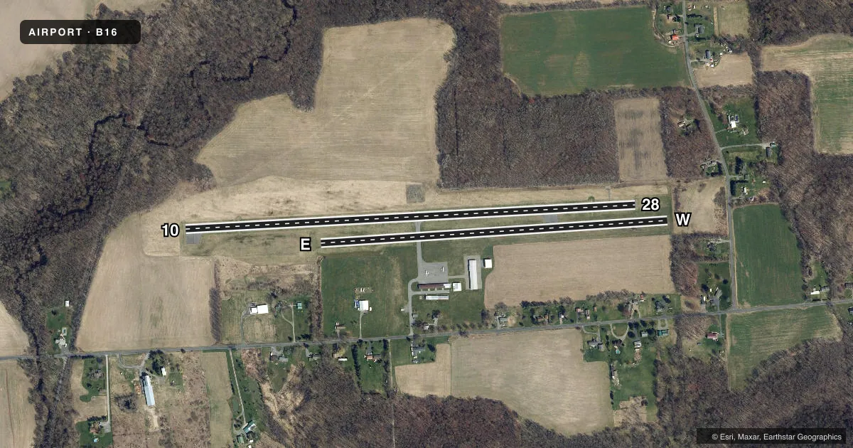
Runways & pattern
Full pagePattern entry · RWY E
LEFT TRAFFIC| Runway | Heading (°M) | Length | Surface | Traffic |
|---|---|---|---|---|
| 10/28 | 75° / 255° | 3,630 ft | ASPH | Standard L |
| E/WFavored | 74° / 254° | 2,800 ft | TURF | Standard L |
Runway end performance
| End | TORA | TODA | ASDA | LDA | VGSI | Approach lights | Obstruction |
|---|---|---|---|---|---|---|---|
| 10 | — | — | — | — | — | — | 64', trees, 314' from thr, 206' R of cntrln, slope 1 |
| 28 | — | — | — | — | — | — | 83', trees, 350' from thr, 270' R of cntrln, slope 1 |
| E | — | — | — | — | — | — | 25', hill, 373' from thr, 100' R of cntrln, slope 14 |
| W | — | — | — | — | — | — | 63', trees, 9' from thr, 105' R of cntrln, slope 0 |
Declared distances in feet. TORA = takeoff run available, TODA = takeoff distance, ASDA = accelerate-stop, LDA = landing distance.
Airport sketch
Runways drawn to scale from FAA survey coordinates, rendered over satellite imagery. Not for navigation.
Approaches & charts
Services on the field
Fuel grades, oxygen, maintenance, ramp storage and lighting — as declared to the FAA by the airport operator.
Fuel & services
- Fuel
- 100LL
- Airframe repair
- Minor
- Power plant repair
- Minor
- Other services
- INSTR,PAJA,RNTL
Ramp & ground
- Transient storage
- Tie-down
- Landing fee
- No fee published
- Customs
- Not available
- Lighting schedule
- SEE RMK
- Beacon schedule
- SEE RMK
- Beacon
- White / Green (civil land)(WG)
- Wind indicator
- Lighted
- Segmented circle
- Yes
Fuel & FBOs
Cheapest 100LL and Jet A on the field and nearby. Always confirm with the FBO before taxi.
Airport notes
Surface conditions, obstructions, local procedures, lighting outages and other notes published with each FAA cycle.
General notes
- RWY E/W CLSD NOV 1 - MAY 15.
- ULTRA-LIGHTS ON & INVOF ARPT.
- SKYDIVING ON & INVOF ARPT.
- FOR CD CTC SYRACUSE APCH AT 315-455-6218.
Lighting notes
- BEACON OTS INDEFLY.
- DUSK-2300. FOR ROTG BCN AFTER 2300 CALL 315-834-9950.
- ACTVT MIRL RWY 10/28 - 122.7.
Other notes
- EXISTED PRIOR TO 1959.
VFR map & nearby airports
VFR sectional. Tap any ICAO chip to open that airport.
Key facts · B16
Answer card- ICAO
- B16
- Name
- WHITFORDS
- Location
- WEEDSPORT, NEW YORK
- Elevation
- 400 ft MSL
- Traffic pattern altitude
- 1,200 ft MSL (800 AGL)
- Control tower
- Non-towered (use CTAF)
- Total runways
- 2
- Longest runway
- 10/28 · 3,630 ft
- Published ILS approaches
- 0
- Published frequencies
- 4
- Magnetic variation
- 12°
- Current flight rules
- VFR
- Current wind
- 000° at 4 kt
- Favored runway now
- RWY E
Whitfords is in Weedsport, New York. The field elevation is 400 ft MSL. It has two runways. The longest is runway 10/28 at 3,630 ft. This is a non-towered field, so expect self-announce traffic on CTAF 122.8. Pattern altitude is 800 ft AGL, which is 1,200 ft MSL.
No ILS approaches are published here. The field sits in Syracuse approach airspace for IFR services. For clearance delivery, contact Syracuse Approach at 315-455-6218. The published remarks also note ultralights and skydiving activity on and in the vicinity of the airport. That makes a good scan of the pattern important, especially when joining on the turf runway or crossing the field.
Whitford's Airport is on the field and carries 100LL. The airport beacon is listed as out of service indefinitely. Medium intensity runway lights on runway 10/28 are activated on frequency 122.7. Runway E/W is closed from November 1 to May 15, so plan on the asphalt runway for winter and early spring operations. If you need current lighting or operational details before departure, call the airport operator or Whitford's Airport directly.