METAR & TAF 1H1
1H1 does not publish a METAR.
Showing the nearest reporting station: KSYR (SYRACUSE HANCOCK INTL) · 6.5 NM away. Conditions at 1H1 may differ.
METAR · KSYR
Observed 12:54Z
KSYR 271254Z 00000KT 10SM FEW090 FEW180 SCT200 BKN250 22/17 A2985 RMK AO2 SLP101 T02170172
- Wind
- 000° @ 0 kt
- Visibility
- 10 SM
- Temp / Dew
- 22°C / 17°C
- Altimeter
- 29.85 inHg
- Clouds
- BKN
- Density alt
- 1,404 ft
- Ceiling
- 25,000 ft AGL
- Rules
- VFR
Airport info & contacts
Manager on record, flight service, ARTCC, attendance schedule and pattern altitude — published by the FAA and refreshed every 28 days.
Location
- From city
- 1 NM N
- VFR sectional
- NEW YORK
- ARTCC
- ZBW · BOSTON
- NOTAM facility
- BUF (NOTAM-D)
Airport manager
- Name
- RAYMOND FLORCZYK
- Phone
- 315-699-5734
- Address
- 4885 VER PLANK RD, CLAY NY 13041
Flight service · Hours
- FSS BUF
- BUFFALO1-800-WX-BRIEF
- Attendance
- DALGT
Frequencies
Tap any row to copy the frequency to your clipboard.
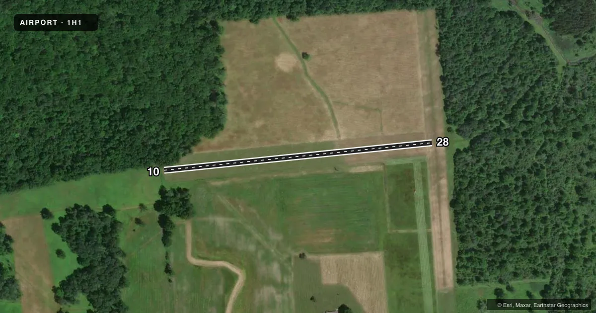
Runways & pattern
Full pagePattern entry · RWY 10
LEFT TRAFFICRunway end performance
| End | TORA | TODA | ASDA | LDA | VGSI | Approach lights | Obstruction |
|---|---|---|---|---|---|---|---|
| 10 | — | — | — | — | — | — | 84', trees, 0' from thr, 70' R of cntrln, slope 0 |
| 28 | — | — | — | — | — | — | 72', trees, 53' from thr, 0' R of cntrln, slope 0 |
Declared distances in feet. TORA = takeoff run available, TODA = takeoff distance, ASDA = accelerate-stop, LDA = landing distance.
Airport sketch
Runways drawn to scale from FAA survey coordinates, rendered over satellite imagery. Not for navigation.
Approaches & charts
Services on the field
Fuel grades, oxygen, maintenance, ramp storage and lighting — as declared to the FAA by the airport operator.
Fuel & services
- Fuel
- Not available
- Airframe repair
- Not available
- Power plant repair
- Not available
Ramp & ground
- Transient storage
- Tie-down
- Landing fee
- No fee published
- Customs
- Not available
- Wind indicator
- Yes
- Segmented circle
- No
Fuel & FBOs
Cheapest 100LL and Jet A on the field and nearby. Always confirm with the FBO before taxi.
Airport notes
Surface conditions, obstructions, local procedures, lighting outages and other notes published with each FAA cycle.
General notes
- PARA PLANE ACTIVITY - EVENINGS & WEEKENDS.
- SKI OPRNS WINTERS.
- RWY 01 30 FT PLINE 260 FT FM THLD.
- DEER ON & INVOF ARPT.
- RWY 10 LINE OF TREES, +95 FT HIGH, 55 FT LEFT.
- FOR CD CTC SYRACUSE APCH AT 315-455-6218.
- 100 FT LONG PARL DITCH RT EDGE OF RWY 01 FIRST 300 FT.
- RWY 01 20 FT VER DROP 100 TO 400 FT FM RWY END.
- FIELD SOFT LATE FALL & EARLY SPRING.
Runway surface & condition
- 01/19WIDTH VARIES 75 FT-90 FT.
- 10/28WIDTH VARIES 97 FT-136 FT.
Approach & departure obstructions
- 0101/19 EDGES MARKED WITH BARRELS.
- 1010/28 EDGES MARKED WITH BARRELS.
- 01CTLNG OBSTN EXCEEDS A 45 DEG SLP.
Other notes
- NON COMPLIANCE WITH FAR 157.
VFR map & nearby airports
VFR sectional. Tap any ICAO chip to open that airport.
Key facts · 1H1
Answer card- ICAO
- 1H1
- Name
- AIRLANE ENTERPRISES
- Location
- CLAY, NEW YORK
- Elevation
- 385 ft MSL
- Traffic pattern altitude
- 1,385 ft MSL (1,000 AGL)
- Control tower
- Non-towered (use CTAF)
- Total runways
- 1
- Longest runway
- 10/28 · 1,550 ft
- Published ILS approaches
- 0
- Published frequencies
- 1
- Magnetic variation
- 12°
- Current flight rules
- VFR
- Current wind
- 000° at 0 kt
- Favored runway now
- –
Airlane Enterprises is in Clay, New York. The field elevation is 385 ft MSL. It has one runway. Runway 10/28 is 1,550 ft long and turf. The airport is not towered. CTAF is 122.9. No ILS approaches are published here.
The pattern altitude is not published, so use standard traffic pattern planning for light piston aircraft unless the current FAA Chart Supplement says otherwise. First-time pilots should pay close attention to the runway remarks. Runway 10 has trees more than 95 ft high on the left side. Runway 01 has a power line near the threshold plus a drop-off beyond the end. Runway 10/28 also has barrel-marked edges and the width varies along the strip. Deer are reported on and near the airport. Parachute plane activity happens in the evenings and on weekends. Ski operations also occur in winter. There are no on-field FBOs listed, so verify services with the airport operator before you go. The published remarks also note noncompliance with FAR 157, so a current check of the FAA Chart Supplement is smart before planning a first visit.