METAR & TAF KVGC
Current METAR
Observed 13:35Z
KVGC 271335Z AUTO 00000KT 10SM CLR 18/ A2988 RMK AO2
- Wind
- 000° @ 0 kt
- Visibility
- 10 SM
- Temp / Dew
- —
- Altimeter
- 29.88 inHg
- Clouds
- CLR
- Density alt
- —
- Ceiling
- Unlimited
- Rules
- VFR
Airport info & contacts
Manager on record, flight service, ARTCC, attendance schedule and pattern altitude — published by the FAA and refreshed every 28 days.
Location
- From city
- 1 NM NW
- VFR sectional
- NEW YORK
- ARTCC
- ZBW · BOSTON
- NOTAM facility
- BUF (NOTAM-D)
Airport manager
- Name
- NANCY MITCHELL
- Phone
- 315-824-1111
- Address
- 3 BROAD STREET - PO BOX 119, HAMILTON NY 13346
Flight service · Hours
- FSS BUF
- BUFFALO1-800-WX-BRIEF
- Attendance
- MAY-SEP · MON-SAT · 0900-1700
- OCT-APR · MON-SAT · 0900-1700
- MAY-SEP · SUN · 0900-1700
- OCT-APR · SUN · 0900-1700
Frequencies
Tap any row to copy the frequency to your clipboard.
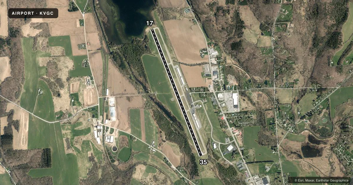
Runways & pattern
Full pagePattern entry · RWY 17
LEFT TRAFFICRunway end performance
| End | TORA | TODA | ASDA | LDA | VGSI | Approach lights | Obstruction |
|---|---|---|---|---|---|---|---|
| 17 | 5,314' | 5,314' | 5,314' | 5,014' | PAPI 2-box left(3°) | — | 98', trees, 1786' from thr, 478' R of cntrln, slope 16 |
| 35 | 5,314' | 5,314' | 5,014' | 5,014' | PAPI 2-box left(4°) | — | 33', trees, 848' from thr, 198' R of cntrln, slope 19 |
Declared distances in feet. TORA = takeoff run available, TODA = takeoff distance, ASDA = accelerate-stop, LDA = landing distance.
Airport sketch
Runways drawn to scale from FAA survey coordinates, rendered over satellite imagery. Not for navigation.
Approaches & charts
Services on the field
Fuel grades, oxygen, maintenance, ramp storage and lighting — as declared to the FAA by the airport operator.
Fuel & services
- Fuel
- 100LLAA+
- Oxygen (bottled)
- Not available
- Oxygen (bulk)
- Not available
- Airframe repair
- Major
- Power plant repair
- Major
- Other services
- GLD,INSTR
Ramp & ground
- Transient storage
- Tie-down
- Landing fee
- No fee published
- Customs
- Not available
- Lighting schedule
- SEE RMK
- Wind indicator
- Lighted
- Segmented circle
- Yes
Fuel & FBOs
Cheapest 100LL and Jet A on the field and nearby. Always confirm with the FBO before taxi.
Airport notes
Surface conditions, obstructions, local procedures, lighting outages and other notes published with each FAA cycle.
General notes
- NOISE ABATEMENT PROCEDURES IN EFFECT; ALL ACFT DEPARTURES MAINTAIN RY HEADING UNTIL 2100 FT MSL BEFORE MAKING TURN OUT.
- MAINT SHOP AP & IA AVBL MON-FRI 0900-1700.
- ULTRALGTS ON & INVOF ARPT.
- RY 17/35 SOUTH END HAS 572 FT SAFETY AREA.
- AFT HR FUEL AVAIL. BY APPT FOR A FEE CTC ARPT MGR.
- TAXI SVC AND CAR RENTAL AVBL.
- DEER ON AND INVOF RY 17/35.
- RWY17: WIND MILLS 3 MI N OF ARPT.
- MIGRATORY BIRDS ON AND INVOF OF ARPT SPRING AND FALL.
- FOR CD CTC SYRACUSE APCH AT 315-455-6218.
- GLDR OPNS INVOF OF ARPT.
Lighting notes
- ACTVT MIRL RY 17/35; REIL RYS 17 & 35 - 122.7.
Approach & departure obstructions
- 1713 FT BRUSH, 90 FT FM RWY END, 75 - 222 FT RIGHT.
- 355 FT. BERM, 109 FT FM THRESHOLD, 179 FT RIGHT.
- 17RWY 17 CLNC SLOPE 29:1 TO DTHR.
VFR map & nearby airports
VFR sectional. Tap any ICAO chip to open that airport.
Key facts · KVGC
Answer card- ICAO
- KVGC
- Name
- HAMILTON MUNI
- Location
- HAMILTON, NEW YORK
- Elevation
- 1,136.7 ft MSL
- Traffic pattern altitude
- 2,136.7 ft MSL (1,000 AGL)
- Control tower
- Non-towered (use CTAF)
- Total runways
- 1
- Longest runway
- 17/35 · 5,314 ft
- Published ILS approaches
- 0
- Published frequencies
- 4
- Magnetic variation
- 11°
- Current flight rules
- VFR
- Current wind
- 000° at 0 kt
- Favored runway now
- –
Hamilton Muni sits in Hamilton, New York at 1,136.7 ft MSL. It has one asphalt runway, 17/35. The longest runway is 5,314 ft. The field is not towered. Syracuse Approach handles clearance delivery and approach or departure services on 126.125 and 269.125. No ILS approaches are published here.
Pattern altitude is not published. For light piston traffic, use 1,000 ft AGL as the standard unless the current Chart Supplement says otherwise. The on-field FBO is Hamilton Municipal Airport. It carries 100LL and Jet A. Call (315) 824-6681 for current service details.
There are a few items a first-time pilot should plan around. Noise abatement is published. Departures must hold runway heading until 2,100 ft MSL before turning. Deer, migratory birds and glider activity are all noted in the area. There is also a 5-foot berm near the threshold area on runway 35. Brush is near the runway 17 end. Runway 17/35 has medium intensity lights and runway end identifier lights. After-hours fuel is available by appointment through the airport manager. Taxi service and car rental are also available.