METAR & TAF KOIC
Current METAR
Observed 11:55Z
KOIC 271155Z AUTO 17004KT 1/4SM FG VV002 15/15 A2989 RMK AO2 10163 20146 70007
- Wind
- 170° @ 4 kt
- Visibility
- 0.25 SM
- Temp / Dew
- 15°C / 15°C
- Altimeter
- 29.89 inHg
- Clouds
- VV
- Density alt
- 1,307 ft
- Ceiling
- 200 ft AGL
- Rules
- LIFR
Airport info & contacts
Manager on record, flight service, ARTCC, attendance schedule and pattern altitude — published by the FAA and refreshed every 28 days.
Location
- From city
- 2 NM N
- VFR sectional
- NEW YORK
- ARTCC
- ZBW · BOSTON
- NOTAM facility
- OIC (NOTAM-D)
Airport manager
- Name
- SHANE H. BUTLER
- Phone
- 607-334-9430
- Address
- 6390 STATE HWY 12, NORWICH NY 13815
Flight service · Hours
- FSS BUF
- BUFFALO1-800-WX-BRIEF
- Attendance
- MON-FRI · 0700-1500
Frequencies
Tap any row to copy the frequency to your clipboard.
Runways & pattern
Full pagePattern entry · RWY 19
LEFT TRAFFICRunway end performance
| End | TORA | TODA | ASDA | LDA | VGSI | Approach lights | Obstruction |
|---|---|---|---|---|---|---|---|
| 01 | 4,727' | 4,727' | 4,394' | 4,119' | PAPI 2-box left(4°) | — | 41', trees, 502' from thr, 18' R of cntrln, slope 7 |
| 19 | 4,727' | 4,727' | 4,452' | 4,119' | PAPI 2-box left(3.75°) | — | 19', road, 301' from thr, 134' R of cntrln, slope 5 |
Declared distances in feet. TORA = takeoff run available, TODA = takeoff distance, ASDA = accelerate-stop, LDA = landing distance.
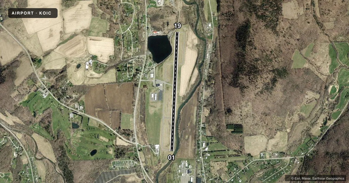
Airport sketch
Runways drawn to scale from FAA survey coordinates, rendered over satellite imagery. Not for navigation.
Approaches & charts
Services on the field
Fuel grades, oxygen, maintenance, ramp storage and lighting — as declared to the FAA by the airport operator.
Fuel & services
- Fuel
- 100LLAA+
- Oxygen (bottled)
- Not available
- Oxygen (bulk)
- Not available
- Airframe repair
- Not available
- Power plant repair
- Not available
- Other services
- AMB
Ramp & ground
- Transient storage
- Tie-down
- Hangar
- Landing fee
- No fee published
- Customs
- Not available
- Lighting schedule
- SEE RMK
- Beacon schedule
- SS-SR
- Beacon
- White / Green (civil land)(WG)
- Wind indicator
- Lighted
- Segmented circle
- Yes
Fuel & FBOs
Cheapest 100LL and Jet A on the field and nearby. Always confirm with the FBO before taxi.
Airport notes
Surface conditions, obstructions, local procedures, lighting outages and other notes published with each FAA cycle.
General notes
- NUMEROUS MTNS PIERCE CONICAL SFC AROUND ARPT.
- RY 19 HAS 15 FT DROPOFF 30 FT FM THLD ON WEST SIDE.
- RY SAFETY AREAS HAVE DEPRESSIONS IN SFC.
- GEESE & DEER ON & INVOF ARPT.
- FOR CD CTC BOSTON ARTCC AT 603-879-6859.
- COLD TEMPERATURE AIRPORT. ALTITUDE CORRECTION REQUIRED AT OR BELOW -24C.
Lighting notes
- ACTVT REIL RWY 19; PAPI RWY 01 & 19; HIRL RWY 01/19 - CTAF.
Fuel notes
- 100LLSELF-SVC FUEL AVBL 24/7 WITH CREDIT CARD.
Approach & departure obstructions
- 01RWY 01 46 FT TREES, 0-200 FT FM RWY END, 222 FT RIGHT OF CNTRLN.
- 19RWY 19 +6 FT TREE 154 FT FM RWY END 75 FT RIGHT.
- 01UNUSBL BYD 4 DEGS LEFT OF CNTRLN.
- 19UNUSBL BYD 3 NM AND BYD 4 DEGS LEFT OF CNTRLN.
- 01RWY 01 6:1 CLOSE IN SLP TO DTHR +45 FT TREE 11 FT FM RWY END 216 FT RIGHT.
- 19RWY 19 - 50:1 SLP TO DTHR.
Other notes
- ARPT ESTABLISHED 6/17/52.
- OVNGT TIE-DOWN FEE; FEE WAIVED WITH FUEL PURCHASE.
- 1UNATNDD CHRISTMAS.
VFR map & nearby airports
VFR sectional. Tap any ICAO chip to open that airport.
Key facts · KOIC
Answer card- ICAO
- KOIC
- Name
- LT WARREN EATON
- Location
- NORWICH, NEW YORK
- Elevation
- 1,024.2 ft MSL
- Traffic pattern altitude
- 2,024.2 ft MSL (1,000 AGL)
- Control tower
- Non-towered (use CTAF)
- Total runways
- 1
- Longest runway
- 01/19 · 4,727 ft
- Published ILS approaches
- 0
- Published frequencies
- 2
- Magnetic variation
- 11°
- Current flight rules
- LIFR
- Current wind
- 170° at 4 kt
- Favored runway now
- RWY 19
LT WARREN EATON is in Norwich, New York. The field elevation is 1,024.4 ft MSL. It has one asphalt runway, 01/19, at 4,727 ft. There is no control tower. CTAF and UNICOM are both 122.8. No ILS approaches are published here.
The published pattern altitude is not listed. Use the standard 1,000 ft AGL pattern unless local procedures or the current Chart Supplement say otherwise. The airport sits in terrain with numerous mountains piercing the conical surface around it. That matters on arrival and departure, especially with a high field elevation and cold weather performance. This is also a cold temperature airport. Altitude correction is required at or below minus 24 degrees Celsius.
Chenango County Airport is on the field. It carries 100LL and Jet A. Self-serve 100LL is available 24 hours a day with a credit card. Runway 19 has PAPI and high intensity lights controlled by CTAF. Runway 01 also has PAPI and high intensity lights. Be aware of the published obstructions near both runway ends. Runway 01 has close-in trees off the right side. Runway 19 has a tree near the departure end. Runway safety areas also have depressions in the surface. For clearance delivery, contact Boston ARTCC at 603-879-6859.