METAR & TAF KCZG
KCZG does not publish a METAR.
Showing the nearest reporting station: KBGM (GREATER BINGHAMTON/EDWIN A LINK FLD) · 9.4 NM away. Conditions at KCZG may differ.
METAR · KBGM
Observed 10:33Z
KBGM 271033Z 28005KT 8SM SCT001 BKN050 16/15 A2989 RMK AO2 T01560150 $
- Wind
- 280° @ 5 kt
- Visibility
- 8 SM
- Temp / Dew
- 16°C / 15°C
- Altimeter
- 29.89 inHg
- Clouds
- BKN
- Density alt
- 1,190 ft
- Ceiling
- 5,000 ft AGL
- Rules
- VFR
Airport info & contacts
Manager on record, flight service, ARTCC, attendance schedule and pattern altitude — published by the FAA and refreshed every 28 days.
Location
- From city
- 3 NM SW
- VFR sectional
- NEW YORK
- ARTCC
- ZNY · NEW YORK
- NOTAM facility
- CZG (NOTAM-D)
Airport manager
- Name
- DOUG MALARKEY
- Phone
- 607-760-7826
- Address
- 351 INDUSTRIAL PK, ENDICOTT NY 13760
Flight service · Hours
- FSS BUF
- BUFFALO1-800-WX-BRIEF
- Attendance
- ATNDD
Frequencies
Tap any row to copy the frequency to your clipboard.
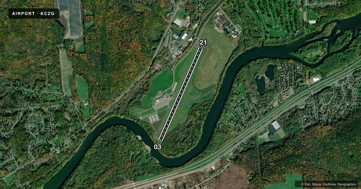
Runways & pattern
Full pagePattern entry · RWY 21
LEFT TRAFFICRunway end performance
| End | TORA | TODA | ASDA | LDA | VGSI | Approach lights | Obstruction |
|---|---|---|---|---|---|---|---|
| 03 | — | — | — | — | — | — | 4', road, 210' from thr, 0' R of cntrln, slope 2 |
| 21 | — | — | — | — | PAPI 2-box right(4°) | — | 19', road, 200' from thr, 248' R of cntrln, slope 0 |
Declared distances in feet. TORA = takeoff run available, TODA = takeoff distance, ASDA = accelerate-stop, LDA = landing distance.
Airport sketch
Runways drawn to scale from FAA survey coordinates, rendered over satellite imagery. Not for navigation.
Approaches & charts
Services on the field
Fuel grades, oxygen, maintenance, ramp storage and lighting — as declared to the FAA by the airport operator.
Fuel & services
- Fuel
- 100LL
- Oxygen (bottled)
- Not available
- Oxygen (bulk)
- Not available
- Airframe repair
- Not available
- Power plant repair
- Not available
Ramp & ground
- Transient storage
- Tie-down
- Hangar
- Landing fee
- No fee published
- Customs
- Not available
- Lighting schedule
- SEE RMK
- Beacon schedule
- SS-SR
- Beacon
- White / Green (civil land)(WG)
- Wind indicator
- Lighted
- Segmented circle
- Yes
Fuel & FBOs
Cheapest 100LL and Jet A on the field and nearby. Always confirm with the FBO before taxi.
Airport notes
Surface conditions, obstructions, local procedures, lighting outages and other notes published with each FAA cycle.
General notes
- HIGH TENSION TWRS 2000 FT FROM RWY 21 THLD 60-70 FT TALL.
- MICROWAVE TOWER +600' 2.8 MILES OUT 3150' L OF RY 21; APCH - UNMKD/UNLGTD 24:1 SLOPE.
- HIGH TERRAIN ALL QUADRANTS.
- RWY 21 EXTDD SAFETY AREA HAS SURFACE VARIATIONS/DEPRESSIONS.
- GRVL ACCESS ROAD CROSSES RY 03 APCH.
- WHEN APCH CLSD, FOR CD CTC NEW YORK ARTCC AT 631-468-1425.
- COLD TEMPERATURE AIRPORT. ALTITUDE CORRECTION REQUIRED AT OR BELOW -16C.
- FBO SVCS CLSD.
Lighting notes
- ROTG BEACON OBSCURED NORTH & WEST OF ARPT DUE TO HIGH TERRAIN.
- ACTVT REIL RY 03/21; MIRL RY 03/21 - CTAF.
Fuel notes
- 100LL24 SELF SVC FUEL AVBL WITH CREDIT CARD.
Approach & departure obstructions
- 03+10 FT ROAD 0 FT OUT AND 63 FT RIGHT
Other notes
- 2CALL ARPT MGR FOR SPECIFIC ATTENDANCE TIMES.
VFR map & nearby airports
VFR sectional. Tap any ICAO chip to open that airport.
Key facts · KCZG
Answer card- ICAO
- KCZG
- Name
- TRI-CITIES
- Location
- ENDICOTT, NEW YORK
- Elevation
- 832.7 ft MSL
- Traffic pattern altitude
- 1,832.7 ft MSL (1,000 AGL)
- Control tower
- Non-towered (use CTAF)
- Total runways
- 1
- Longest runway
- 03/21 · 3,900 ft
- Published ILS approaches
- 0
- Published frequencies
- 5
- Magnetic variation
- 12°
- Current flight rules
- VFR
- Current wind
- 280° at 5 kt
- Favored runway now
- RWY 21
Tri-Cities Airport sits in Endicott, New York. Field elevation is 832.7 ft MSL. The airport has one runway. Runway 03/21 is 3,900 ft long with asphalt pavement. There is no control tower. The published pattern altitude is not listed, so use the standard 1,000 ft AGL for light piston traffic unless the current FAA Chart Supplement says otherwise. No ILS approaches are published here.
This field is served by Binghamton approach and departure on 118.6 and 257.625. CTAF and UNICOM are both 122.8. The on-field FBO is Tri-Cities Airport. It carries AVGAS 100LL. Twenty-four hour self-serve 100LL is available with credit card. The published remarks also note that FBO services are closed. Call the airport manager for current attendance times before you go.
First-time pilots should pay close attention to the terrain. High terrain surrounds the airport in all quadrants. The rotating beacon is obscured to the north and west. Runway 03 has a road 10 feet tall near the threshold area. A gravel access road crosses the runway 03 approach. Runway 21 has surface variations and depressions in the extended safety area. There is also a microwave tower more than 600 feet tall about 2.8 miles out on the 21 side. This is a cold temperature airport. Altitude correction is required at or below minus 16 degrees Celsius.