METAR & TAF N03
Current METAR
Observed 12:35Z
KN03 271235Z AUTO 00000KT 10SM CLR 17/16 A2989 RMK AO2
- Wind
- 000° @ 0 kt
- Visibility
- 10 SM
- Temp / Dew
- 17°C / 16°C
- Altimeter
- 29.89 inHg
- Clouds
- CLR
- Density alt
- 1,762 ft
- Ceiling
- Unlimited
- Rules
- VFR
Airport info & contacts
Manager on record, flight service, ARTCC, attendance schedule and pattern altitude — published by the FAA and refreshed every 28 days.
Location
- From city
- 2 NM SW
- VFR sectional
- NEW YORK
- ARTCC
- ZBW · BOSTON
- NOTAM facility
- N03 (NOTAM-D)
Airport manager
- Name
- MATT WETHERELL
- Phone
- 607-745-5872
- Address
- 60 CENTRAL AVE., CORTLAND NY 13045
Flight service · Hours
- FSS BUF
- BUFFALO1-800-WX-BRIEF
- Attendance
- MON-FRI · 0700-1530
Frequencies
Tap any row to copy the frequency to your clipboard.
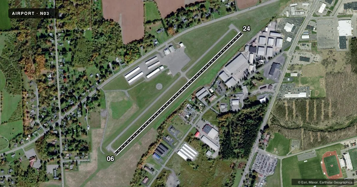
Runways & pattern
Full pagePattern entry · RWY 06
LEFT TRAFFICRunway end performance
| End | TORA | TODA | ASDA | LDA | VGSI | Approach lights | Obstruction |
|---|---|---|---|---|---|---|---|
| 06 | — | — | — | — | PAPI 2-box left(4°) | — | 36', pole, 515' from thr, 294' R of cntrln, slope 8 |
| 24 | — | — | — | — | PAPI 2-box left(4°) | — | 23', trees, 665' from thr, 178' R of cntrln, slope 20 |
Declared distances in feet. TORA = takeoff run available, TODA = takeoff distance, ASDA = accelerate-stop, LDA = landing distance.
Airport sketch
Runways drawn to scale from FAA survey coordinates, rendered over satellite imagery. Not for navigation.
Approaches & charts
Services on the field
Fuel grades, oxygen, maintenance, ramp storage and lighting — as declared to the FAA by the airport operator.
Fuel & services
- Fuel
- 100LLA+
- Oxygen (bottled)
- Not available
- Oxygen (bulk)
- Not available
- Airframe repair
- Major
- Power plant repair
- Major
- Other services
- INSTR,RNTL
Ramp & ground
- Transient storage
- Tie-down
- Hangar
- Landing fee
- No fee published
- Customs
- Not available
- Lighting schedule
- SEE RMK
- Beacon schedule
- SS-SR
- Beacon
- White / Green (civil land)(WG)
- Wind indicator
- Lighted
- Segmented circle
- Yes
Fuel & FBOs
Cheapest 100LL and Jet A on the field and nearby. Always confirm with the FBO before taxi.
Airport notes
Surface conditions, obstructions, local procedures, lighting outages and other notes published with each FAA cycle.
General notes
- SNOW REMOVAL DRG DAY ONLY.
- HVY CONCENTRATION OF GEESE AND GULLS ON AND INVOF ARPT DRG SPRING/FALL.
- FOR CD CTC SYRACUSE APCH AT 315-455-6218.
Lighting notes
- ACTVT REIL RWY 24; PAPI RWY 06 & 24; MIRL RWY 06/24; TWY LGTS - CTAF.
Fuel notes
- 100LLSELF SVC AVBL 24 HRS WITH CREDIT CARD.
- A+SELF SVC AVBL 24 HRS WITH CREDIT CARD.
Other notes
- FILED FOR RCRD PURPOSES ONLY.
- 2UNATNDD HOLIDAYS, OTR HRS CALL ARPT MGR.
VFR map & nearby airports
VFR sectional. Tap any ICAO chip to open that airport.
Key facts · N03
Answer card- ICAO
- N03
- Name
- CORTLAND COUNTY/CHASE FLD
- Location
- CORTLAND, NEW YORK
- Elevation
- 1,197.3 ft MSL
- Traffic pattern altitude
- 2,197.3 ft MSL (1,000 AGL)
- Control tower
- Non-towered (use CTAF)
- Total runways
- 1
- Longest runway
- 06/24 · 3,401 ft
- Published ILS approaches
- 0
- Published frequencies
- 8
- Magnetic variation
- 13°
- Current flight rules
- VFR
- Current wind
- 000° at 0 kt
- Favored runway now
- –
Cortland County/Chase Fld (N03) sits in Cortland, New York. Field elevation is 1,197.3 ft MSL. The airport has one runway. Runway 06/24 is 3,401 ft long. There is no control tower. Pattern altitude is not published, so use the standard 1,000 ft AGL for light piston traffic unless the current Chart Supplement says otherwise.
No ILS approaches are published here. The field is served by CTAF and UNICOM on 122.8. For clearance delivery, Syracuse Approach is the published contact. The airport sits in a part of upstate New York where winter weather can matter. Snow removal is done during the day only, so plan arrivals with that in mind if conditions are marginal.
Cortland County Airport is on the field. It carries 100LL and Jet A. Self-service fuel is available 24 hours with a credit card. Runway 24 has REILs. Runways 06 and 24 have PAPI. Medium intensity runway lights are on both ends. Taxiway lights are controlled by the CTAF. First-time visitors should also watch for geese and gulls in spring and fall. The airport is unattended on holidays. For other hours, call the airport manager before you go.