METAR & TAF KITH
Current METAR
Observed 10:56Z
KITH 271056Z 08004KT 10SM SCT055 16/16 A2987 RMK AO2 SLP110 T01560156 $
- Wind
- 080° @ 4 kt
- Visibility
- 10 SM
- Temp / Dew
- 16°C / 16°C
- Altimeter
- 29.87 inHg
- Clouds
- SCT
- Density alt
- 1,545 ft
- Ceiling
- Unlimited
- Rules
- VFR
Airport info & contacts
Manager on record, flight service, ARTCC, attendance schedule and pattern altitude — published by the FAA and refreshed every 28 days.
Location
- From city
- 3 NM NE
- VFR sectional
- NEW YORK
- ARTCC
- ZNY · NEW YORK
- NOTAM facility
- ITH (NOTAM-D)
Airport manager
- Name
- ROXAN NOBLE
- Phone
- 607-257-0456
- Address
- 72 BROWN RD, ITHACA NY 14850
Flight service · Hours
- FSS BUF
- BUFFALO1-800-WX-BRIEF
- Attendance
- ALL
Frequencies
Tap any row to copy the frequency to your clipboard.
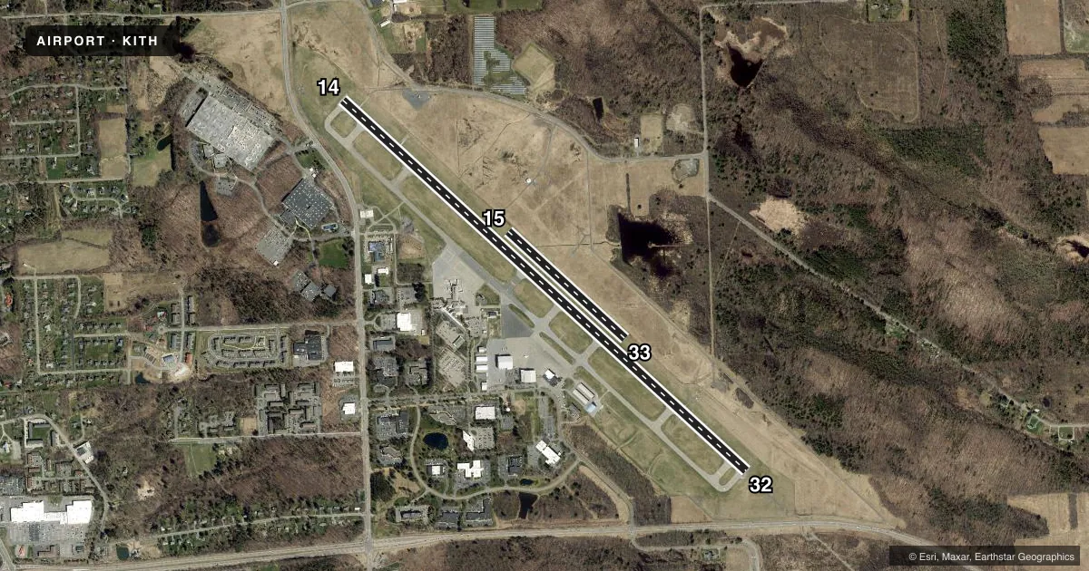
Runways & pattern
Full pagePattern entry · RWY 15U
LEFT TRAFFIC| Runway | Heading (°M) | Length | Surface | Traffic |
|---|---|---|---|---|
| 14/32 | 121° / 301° | 6,977 ft | ASPH | Standard L |
| 15U/33UFavored | 120° / 301° | 2,018 ft | TURF | Standard L |
Runway end performance
| End | TORA | TODA | ASDA | LDA | VGSI | Approach lights | Obstruction |
|---|---|---|---|---|---|---|---|
| 14 | 6,977' | 6,977' | 6,602' | 6,602' | PAPI 4-box left(3°) | — | — |
| 32 | 6,977' | 6,977' | 6,602' | 6,602' | PAPI 4-box left(3.2°) | MALSR | 642', trees, 20360' from thr, 2000' R of cntrln, slope 31 |
| 15U | — | — | — | — | — | — | 15', road, 238' from thr, 0' R of cntrln, slope 15 |
| 33U | — | — | — | — | — | — | 55', ant, 1200' from thr, 50' R of cntrln, slope 21 |
Declared distances in feet. TORA = takeoff run available, TODA = takeoff distance, ASDA = accelerate-stop, LDA = landing distance.
Airport sketch
Runways drawn to scale from FAA survey coordinates, rendered over satellite imagery. Not for navigation.
Approaches & charts
ILS · 1
Services on the field
Fuel grades, oxygen, maintenance, ramp storage and lighting — as declared to the FAA by the airport operator.
Fuel & services
- Fuel
- 100LLA
- Oxygen (bottled)
- Not available
- Oxygen (bulk)
- Not available
- Airframe repair
- Major
- Power plant repair
- Major
- Other services
- CHTR,INSTR,RNTL
Ramp & ground
- Transient storage
- Tie-down
- Hangar
- Landing fee
- Yes
- Customs
- Not available
- Lighting schedule
- SEE RMK
- Beacon schedule
- SS-SR
- Beacon
- White / Green (civil land)(WG)
- Wind indicator
- Lighted
- Segmented circle
- No
Fuel & FBOs
Cheapest 100LL and Jet A on the field and nearby. Always confirm with the FBO before taxi.
Airport notes
Surface conditions, obstructions, local procedures, lighting outages and other notes published with each FAA cycle.
General notes
- DEER & FLOCKS OF BIRDS ON & INVOF ARPT.
- COLD TEMPERATURE AIRPORT. ALTITUDE CORRECTION REQUIRED AT OR BELOW -18C.
- FOR CD IF UNA TO CTC ON FSS FREQ, CTC NEW YORK ARTCC.
- FOR CD WHEN TWR AND ELM APCH CLSD CTC NEW YORK ARTCC.
- PILOTS CONDUCTING EFVS OPS; BE AWARE LED ALS IN USE RWY 32.
Lighting notes
- WHEN ATCT CLSD ACTVT MALSR RWY 32; HIRL RWY 14/32; TWY LGTS - CTAF. PAPI RWYS 14 & 32 OPR CONSLY.
Runway surface & condition
- 14/32PCR VALUE: 980/F/B/X/T
- 15U/33URWY 15/33 CLSD NGTS, WINTER MONTHS AND AFT HVY RAIN.
Approach & departure obstructions
- 15URWY 15/33 THRS MKD WITH WHITE LIME BAR; EDGES MKD WITH REFLECTORS.
Other notes
- FILED FOR RECORD PURPOSES ONLY.
- LDG FEE FOR TSNT ACFT.
- UNICOM UNMON.
- 1FBO AVBL 0600-1900; FBO SVCS CTC 131.6; AFT HRS CALL 607-279-0392 OR 800-876-1551.
VFR map & nearby airports
VFR sectional. Tap any ICAO chip to open that airport.
Key facts · KITH
Answer card- ICAO
- KITH
- Name
- ITHACA TOMPKINS INTL
- Location
- ITHACA, NEW YORK
- Elevation
- 1,099 ft MSL
- Traffic pattern altitude
- 2,099 ft MSL (1,000 AGL)
- Control tower
- Towered · 0530-2100
- Total runways
- 2
- Longest runway
- 14/32 · 6,977 ft
- Published ILS approaches
- 1
- Published frequencies
- 9
- Magnetic variation
- 12°
- Current flight rules
- VFR
- Current wind
- 080° at 4 kt
- Favored runway now
- RWY 15U
Ithaca Tompkins Intl is in Ithaca, New York. The field elevation is 1,099 ft MSL. It has two runways. The longest is runway 14/32 at 6,977 ft. Runway 15/33 is turf at 2,018 ft. The airport has a control tower. Tower hours are 0530-2100.
There is one ILS approach. It is for runway 32. Pattern altitude is not published. Use the standard 1,000 ft AGL pattern for light piston aircraft unless the current Chart Supplement says otherwise. Taughannock Aviation is on the field. It carries 100LL, Jet A and Jet A Prist. The FBO is available from 0600 to 1900. For after-hours service, call the number in the Chart Supplement or the airport operator.
A few remarks matter here. Runway 15/33 is closed at night, during winter months and after heavy rain. Deer and birds are reported on and near the airport. The field is also a cold temperature airport, so altitude correction is required at or below minus 18 C. When the tower is closed, lighting for runway 32 and the taxiways is activated on CTAF. Precision path indicators for runways 14 and 32 operate continuously. Check current procedures before arrival if you are planning a night or winter operation.