METAR & TAF N23
N23 does not publish a METAR.
Showing the nearest reporting station: KOIC (LT WARREN EATON) · 16.6 NM away. Conditions at N23 may differ.
METAR · KOIC
Observed 12:15Z
KOIC 271215Z AUTO VRB03KT 3/4SM BR BKN001 15/15 A2989 RMK AO2
- Wind
- VAR @ 3 kt
- Visibility
- 0.75 SM
- Temp / Dew
- 15°C / 15°C
- Altimeter
- 29.89 inHg
- Clouds
- BKN
- Density alt
- 1,311 ft
- Ceiling
- 100 ft AGL
- Rules
- LIFR
Airport info & contacts
Manager on record, flight service, ARTCC, attendance schedule and pattern altitude — published by the FAA and refreshed every 28 days.
Location
- From city
- 1 NM W
- VFR sectional
- NEW YORK
- ARTCC
- ZBW · BOSTON
- NOTAM facility
- BUF (NOTAM-D)
Airport manager
- Name
- CHARLES WASHBURN
- Phone
- 607-561-2346
- Address
- 199 RIVER ST, SIDNEY NY 13838
Flight service · Hours
- FSS BUF
- BUFFALO1-800-WX-BRIEF
- Attendance
- 0800-1700
Frequencies
Tap any row to copy the frequency to your clipboard.
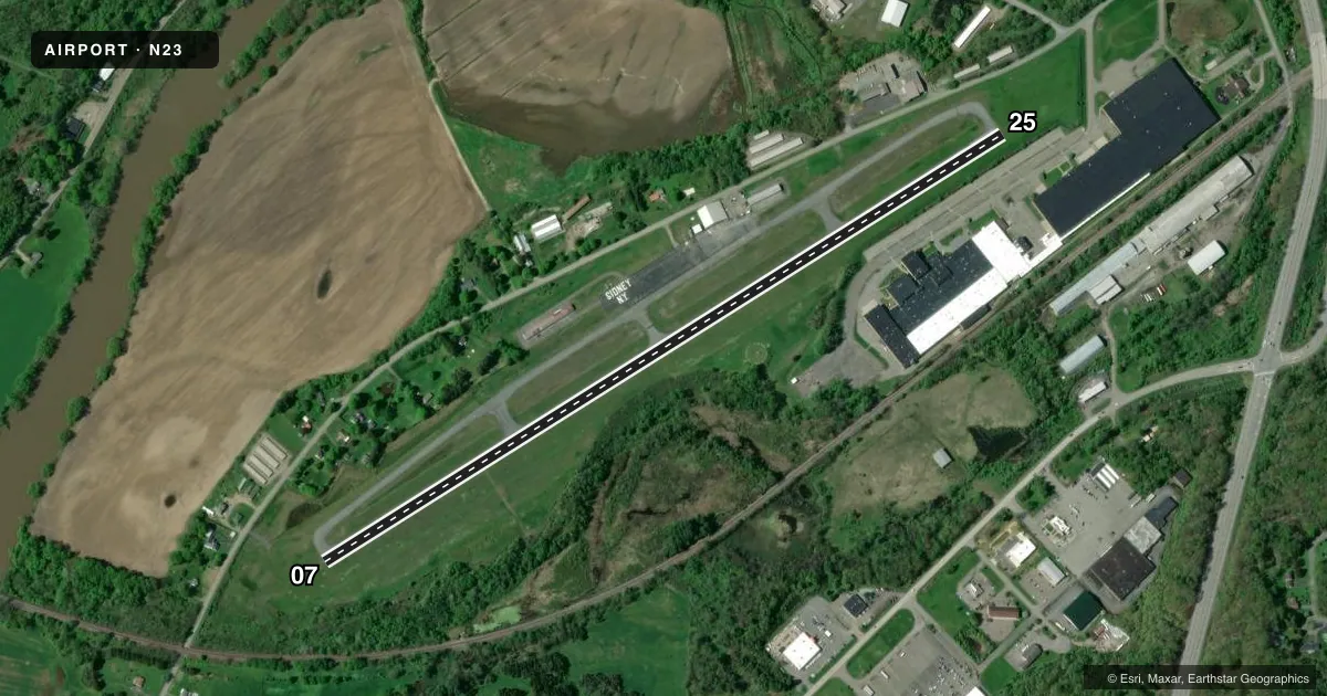
Runways & pattern
Full pagePattern entry · RWY 07
LEFT TRAFFICRunway end performance
| End | TORA | TODA | ASDA | LDA | VGSI | Approach lights | Obstruction |
|---|---|---|---|---|---|---|---|
| 07 | — | — | — | — | — | — | 50', tree, 707' from thr, 236' R of cntrln, slope 10 |
| 25 | — | — | — | — | PAPI 2-box right(3.66°) | — | 56', tree, 676' from thr, 298' R of cntrln, slope 8 |
Declared distances in feet. TORA = takeoff run available, TODA = takeoff distance, ASDA = accelerate-stop, LDA = landing distance.
Airport sketch
Runways drawn to scale from FAA survey coordinates, rendered over satellite imagery. Not for navigation.
Approaches & charts
Services on the field
Fuel grades, oxygen, maintenance, ramp storage and lighting — as declared to the FAA by the airport operator.
Fuel & services
- Fuel
- 100LLA
- Oxygen (bottled)
- HIGH/LOW
- Oxygen (bulk)
- Not available
- Airframe repair
- Major
- Power plant repair
- Major
- Other services
- AFRT,AMB,CARGO,CHTR,INSTR,RNTL,SALES
Ramp & ground
- Transient storage
- Tie-down
- Hangar
- Landing fee
- No fee published
- Customs
- Not available
- Lighting schedule
- SEE RMK
- Beacon schedule
- SS-SR
- Beacon
- White / Green (civil land)(WG)
- Wind indicator
- Lighted
- Segmented circle
- Yes
Fuel & FBOs
Cheapest 100LL and Jet A on the field and nearby. Always confirm with the FBO before taxi.
Airport notes
Surface conditions, obstructions, local procedures, lighting outages and other notes published with each FAA cycle.
General notes
- NUMEROUS HILLS SURROUND ARPT UP TO +800 FT ABV ARPT ELEV.
- HIGH TENSION LINES +1 MI FROM AER 07.
- AWOS 118.275
- FOR CD CTC BOSTON ARTCC AT 603-879-6859.
- TWO FT HIGH CEMENT FIXTURES IN PRIM SFC IN DITCHES 130 FT W OF RWY.
- FENCE 7 FT ABV RWY END 325 FT RIGHT OF CNTRLN.
- COLD TEMPERATURE AIRPORT. ALTITUDE CORRECTION REQUIRED AT OR BELOW -20C.
Lighting notes
- ACTVT MIRL RY 07/25 & REIL RYS 07 & 25 - CTAF.
Approach & departure obstructions
- 25RY 25 NUMEROUS 28-80 FT. TREES, 300 FT. 'R', EXTENDING TO 1500 FT FM THRESHOLD.
Other notes
- PUBLIC USE IAP PENDING.
- 1FOR ATTENDANT OTHER TIMES CALL 607-561-2346.
VFR map & nearby airports
VFR sectional. Tap any ICAO chip to open that airport.
Key facts · N23
Answer card- ICAO
- N23
- Name
- SIDNEY MUNI
- Location
- SIDNEY, NEW YORK
- Elevation
- 1,026.9 ft MSL
- Traffic pattern altitude
- 2,026.9 ft MSL (1,000 AGL)
- Control tower
- Non-towered (use CTAF)
- Total runways
- 1
- Longest runway
- 07/25 · 4,201 ft
- Published ILS approaches
- 0
- Published frequencies
- 2
- Magnetic variation
- 13°
- Current flight rules
- LIFR
- Current wind
- 000° at 3 kt
- Favored runway now
- RWY 07
Sidney Muni sits in Sidney, New York at 1,026.9 ft MSL. It has one runway, 07/25, which is 4,201 ft long and paved. The field is non-towered. CTAF and UNICOM are both 122.8. No ILS approaches are published. Pattern altitude is not published, so use the standard 1,000 ft AGL for light piston traffic unless the current Chart Supplement says otherwise.
Sidney Municipal Airport is the on-field FBO. It carries 100LL and Jet A Prist. Call (607) 561-2346 for attendant service at other times. The published remarks also note an AWOS on 118.275. This is a cold temperature airport. Altitude correction is required at or below minus 20 degrees Celsius.
Terrain and obstructions matter here. Numerous hills surround the airport up to 800 ft above airport elevation. Runway 25 has trees 28 to 80 ft tall off the right side, extending from 300 ft to 1,500 ft from the threshold. There are also cement fixtures in ditches west of the runway and a fence near the runway end. Runway lights and REILs on 07 and 25 are activated by CTAF. For clearance delivery, contact Boston ARTCC at 603-879-6859. Check the current FAA Chart Supplement before departure for any updated remarks or instrument procedure changes.