METAR & TAF N66
N66 does not publish a METAR.
Showing the nearest reporting station: KOIC (LT WARREN EATON) · 20.5 NM away. Conditions at N66 may differ.
METAR · KOIC
Observed 13:35Z
KOIC 271335Z AUTO 14003KT 10SM SCT003 18/18 A2988 RMK AO2
- Wind
- 140° @ 3 kt
- Visibility
- 10 SM
- Temp / Dew
- 18°C / 18°C
- Altimeter
- 29.88 inHg
- Clouds
- SCT
- Density alt
- 2,596 ft
- Ceiling
- Unlimited
- Rules
- VFR
Airport info & contacts
Manager on record, flight service, ARTCC, attendance schedule and pattern altitude — published by the FAA and refreshed every 28 days.
Location
- From city
- 3 NM N
- VFR sectional
- NEW YORK
- ARTCC
- ZBW · BOSTON
- NOTAM facility
- BUF (NOTAM-D)
Airport manager
- Name
- KERRIANN HARRINGTON
- Phone
- (607) 431-1076
- Address
- 391 AIRPORT RD, ONEONTA NY 13820
Flight service · Hours
- FSS BUF
- BUFFALO1-800-WX-BRIEF
- Attendance
- MON-FRI · 0900-1700
Frequencies
Tap any row to copy the frequency to your clipboard.
Runways & pattern
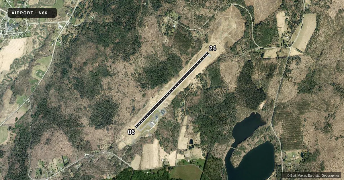
Full pagePattern entry · RWY 24
LEFT TRAFFICRunway end performance
| End | TORA | TODA | ASDA | LDA | VGSI | Approach lights | Obstruction |
|---|---|---|---|---|---|---|---|
| 06 | — | — | — | — | — | — | 68', tree, 818' from thr, 315' R of cntrln, slope 9 |
| 24 | — | — | — | — | PAPI 2-box left(3°) | MALS | 121', fence, 2442' from thr, 518' R of cntrln, slope 18 |
Declared distances in feet. TORA = takeoff run available, TODA = takeoff distance, ASDA = accelerate-stop, LDA = landing distance.
Airport sketch
Runways drawn to scale from FAA survey coordinates, rendered over satellite imagery. Not for navigation.
Approaches & charts
Services on the field
Fuel grades, oxygen, maintenance, ramp storage and lighting — as declared to the FAA by the airport operator.
Fuel & services
- Fuel
- 100LLAA+
- Oxygen (bottled)
- Not available
- Oxygen (bulk)
- Not available
- Airframe repair
- Major
- Power plant repair
- Major
- Other services
- AMB,CARGO,CHTR,INSTR,RNTL
Ramp & ground
- Transient storage
- Tie-down
- Hangar
- Landing fee
- Yes
- Customs
- Not available
- Lighting schedule
- SEE RMK
- Beacon schedule
- SS-SR
- Beacon
- White / Green (civil land)(WG)
- Wind indicator
- Lighted
- Segmented circle
- Yes
Fuel & FBOs
Cheapest 100LL and Jet A on the field and nearby. Always confirm with the FBO before taxi.
Airport notes
Surface conditions, obstructions, local procedures, lighting outages and other notes published with each FAA cycle.
General notes
- FOR CD CTC BOSTON ARTCC AT 603-879-6859.
- (E94) SAWRS
Lighting notes
- BCN TWR PARTIALLY OBSCURED BY TREES.
- ACTVT MALS RWY 24; REIL 06/24; PAPI RWY 24; MIRL RWY 06/24 - CTAF.
Approach & departure obstructions
- 067 FT BERM 150 FT RIGHT AND PARALLEL TO RY 6 PRIMARY SURFACE.
- 24RWY 24 REILS OTS
Other notes
- THIS AIRPORT HAS BEEN SURVEYED BY THE NATIONAL GEODETIC SURVEY.
VFR map & nearby airports
VFR sectional. Tap any ICAO chip to open that airport.
Key facts · N66
Answer card- ICAO
- N66
- Name
- ALBERT S NADER RGNL
- Location
- ONEONTA, NEW YORK
- Elevation
- 1,763.3 ft MSL
- Traffic pattern altitude
- 2,763.3 ft MSL (1,000 AGL)
- Control tower
- Non-towered (use CTAF)
- Total runways
- 1
- Longest runway
- 06/24 · 4,199 ft
- Published ILS approaches
- 0
- Published frequencies
- 2
- Magnetic variation
- 13°
- Current flight rules
- VFR
- Current wind
- 140° at 3 kt
- Favored runway now
- RWY 24
Albert S Nader Rgnl Airport sits in Oneonta, New York. Field elevation is 1,763.3 ft MSL. The airport has one runway, 06/24, which is 4,199 ft long. There is no control tower, so use CTAF 122.8 for airport traffic and UNICOM 122.8 for ground coordination. No ILS approaches are published here.
Pattern altitude is not published. Use the standard 1,000 ft AGL pattern unless local procedures or ATC say otherwise. The field has MALSR lighting on runway 24, with REIL on both ends. PAPI is on runway 24. Runway 24 REILs are out of service, so plan accordingly if you are arriving after dark. The remarks also note a 7-foot berm 150 feet right and parallel to runway 06 primary surface. The beacon tower is partially obscured by trees.
Hawkeye Aviation is on the field. Oneonta Municipal Airport is also listed on the field. Both carry 100LL and Jet A. For clearance delivery, contact Boston ARTCC at 603-879-6859. This is a higher-elevation airport, so expect performance to be a factor on warm days. Check the current Chart Supplement for any published noise or operational updates before you go.