METAR & TAF 6B4
6B4 does not publish a METAR.
Showing the nearest reporting station: KRME (GRIFFISS INTL) · 16.7 NM away. Conditions at 6B4 may differ.
METAR · KRME
Observed 01:53Z
KRME 260153Z AUTO 09003KT 10SM CLR 21/13 A2998 RMK AO2 SLP147 T02110133 $
- Wind
- 090° @ 3 kt
- Visibility
- 10 SM
- Temp / Dew
- 21°C / 13°C
- Altimeter
- 29.98 inHg
- Clouds
- CLR
- Density alt
- 2,289 ft
- Ceiling
- Unlimited
- Rules
- VFR
Airport info & contacts
Manager on record, flight service, ARTCC, attendance schedule and pattern altitude — published by the FAA and refreshed every 28 days.
Location
- From city
- 4 NM SE
- VFR sectional
- NEW YORK
- ARTCC
- ZBW · BOSTON
- NOTAM facility
- BUF (NOTAM-D)
Airport manager
- Name
- THOMAS MAUGERI
- Phone
- 315-796-6257
- Address
- 205 HAMPTON ROAD, FRANKFORT NY 13340
Flight service · Hours
- FSS BUF
- BUFFALO1-800-WX-BRIEF
- Attendance
- Unattended
Frequencies
Tap any row to copy the frequency to your clipboard.
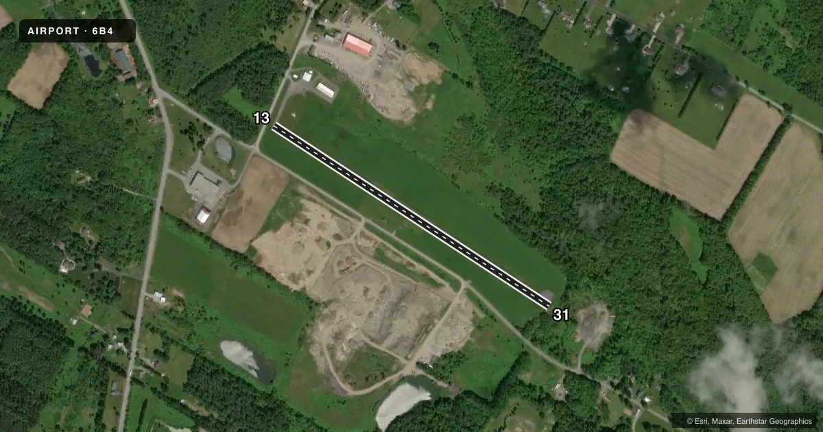
Runways & pattern
Full pagePattern entry · RWY 13
LEFT TRAFFICRunway end performance
| End | TORA | TODA | ASDA | LDA | VGSI | Approach lights | Obstruction |
|---|---|---|---|---|---|---|---|
| 13 | — | — | — | — | — | — | 50', trees, 207' from thr, 75' R of cntrln, slope 0 |
Declared distances in feet. TORA = takeoff run available, TODA = takeoff distance, ASDA = accelerate-stop, LDA = landing distance.
Airport sketch
Runways drawn to scale from FAA survey coordinates, rendered over satellite imagery. Not for navigation.
Approaches & charts
Services on the field
Fuel grades, oxygen, maintenance, ramp storage and lighting — as declared to the FAA by the airport operator.
Fuel & services
- Fuel
- 100LL
- Oxygen (bottled)
- Not available
- Oxygen (bulk)
- Not available
Ramp & ground
- Transient storage
- Tie-down
- Landing fee
- No fee published
- Customs
- Not available
- Lighting schedule
- SEE RMK
- Wind indicator
- Yes
- Segmented circle
- No
Fuel & FBOs
Cheapest 100LL and Jet A on the field and nearby. Always confirm with the FBO before taxi.
Airport notes
Surface conditions, obstructions, local procedures, lighting outages and other notes published with each FAA cycle.
General notes
- RWY 31 HAS 120 FT DROPOFF 90 FT FM THLD, BOTH SIDES.
- LIRL RWY 13/31 NOT AVBL TO TSNT ACFT.
- MODEL PLANE CLUB OPERATES ON ARPT.
- GEESE ON AND INVOF ARPT DURG SPRING AND FALL.
- FOR CD CTC SYRACUSE APCH AT 315-455-6218.
Lighting notes
- RDO-CTL
Fuel notes
- 100LLSELF SERVE FUEL
Approach & departure obstructions
- 13+15 FT ROAD 50 FT FM RWY END; +40 FT TREES, 180 FT FM RWY END, 40 FT LT; +30-60 FT TREES, 100-170 FT FM RWY END, 60-100 FT RT.
- 31+40 FT TREES 30 FT FM RWY END, 65 FT LT.
- 13MARKINGS FADED.
- 31MARKINGS FADED.
- 1315 FT ROAD 50 FT FM RWY END; 40 FT TREES, 180 FT FM RWY END. 40 FT LT, 30-60 FT TREES, 100-170 FT FM RWY END, 60-100 FT RT.
Other notes
- PRVDD OPNS AT ARPT ARE COORDINATED WITH UTICA ATCT.
VFR map & nearby airports
VFR sectional. Tap any ICAO chip to open that airport.
Key facts · 6B4
Answer card- ICAO
- 6B4
- Name
- FRANKFORT-HIGHLAND
- Location
- UTICA/FRANKFORT, NEW YORK
- Elevation
- 1,325 ft MSL
- Traffic pattern altitude
- 2,325 ft MSL (1,000 AGL)
- Control tower
- Non-towered (use CTAF)
- Total runways
- 1
- Longest runway
- 13/31 · 2,750 ft
- Published ILS approaches
- 0
- Published frequencies
- 2
- Magnetic variation
- 13°
- Current flight rules
- VFR
- Current wind
- 090° at 3 kt
- Favored runway now
- RWY 13
Frankfort-Highland (6B4) sits in Utica/Frankfort, New York. Field elevation is 1,325 ft MSL. The airport has one runway, 13/31, which is 2,750 ft long. There is no control tower. Pattern altitude is not published, so plan on the standard 1,000 ft AGL unless the current Chart Supplement says otherwise.
No ILS approaches are published here. CTAF and UNICOM are both 122.8. Davand Aviation is on the field. Fuel grades are not reported in the facts, so verify with the FBO directly before you go. Self-serve fuel is available. Radio-controlled lighting is available too. The remarks also note that low-intensity runway lights on 13/31 are not available to transient aircraft.
This is a field where runway-end awareness matters. The Chart Supplement notes a road close to the runway end plus trees near both ends, with a steep dropoff near the 31 threshold on both sides. Markings on both runway directions are faded. Geese are reported in the area during spring and fall. The airport also has a model plane club on the field. For clearance delivery, contact Syracuse Approach at 315-455-6218. Provided operations at the airport are coordinated with Utica Air Traffic Control Tower. Check the current Chart Supplement before flying in, especially if you are planning a night arrival or anything beyond a simple VFR stop.