METAR & TAF NY0
Current METAR
Observed 12:15Z
KNY0 271215Z AUTO 00000KT 10SM CLR 18/17 A2987 RMK AO2 T01760174
- Wind
- 000° @ 0 kt
- Visibility
- 10 SM
- Temp / Dew
- 18°C / 17°C
- Altimeter
- 29.87 inHg
- Clouds
- CLR
- Density alt
- 1,514 ft
- Ceiling
- Unlimited
- Rules
- VFR
Airport info & contacts
Manager on record, flight service, ARTCC, attendance schedule and pattern altitude — published by the FAA and refreshed every 28 days.
Location
- From city
- 2 NM E
- VFR sectional
- NEW YORK
- ARTCC
- ZBW · BOSTON
- NOTAM facility
- BTV (NOTAM-D)
Airport manager
- Name
- SCOTT HENZE
- Phone
- 518-928-6545
- Address
- 1 EAST MONTGOMERY ST, JOHNSTOWN NY 12095
Flight service · Hours
- FSS BTV
- BURLINGTON1-800-WX-BRIEF
- Attendance
- MON-FRI · 0800-1700
Frequencies
Tap any row to copy the frequency to your clipboard.
Runways & pattern
Full pagePattern entry · RWY 10
LEFT TRAFFICRunway end performance
| End | TORA | TODA | ASDA | LDA | VGSI | Approach lights | Obstruction |
|---|---|---|---|---|---|---|---|
| 10 | — | — | — | — | PAPI 2-box left(3°) | — | — |
| 28 | — | — | — | — | PAPI 2-box left(3°) | — | 14', trees, 310' from thr, 216' R of cntrln, slope 7 |
Declared distances in feet. TORA = takeoff run available, TODA = takeoff distance, ASDA = accelerate-stop, LDA = landing distance.
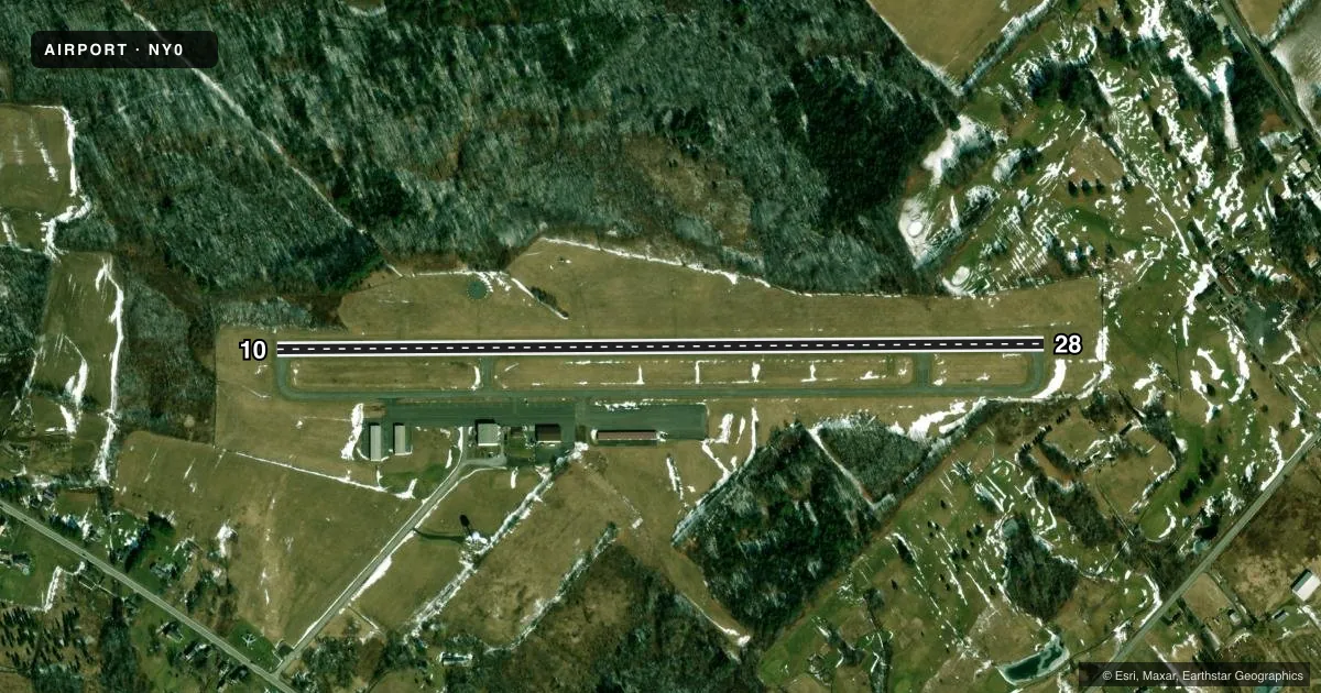
Airport sketch
Runways drawn to scale from FAA survey coordinates, rendered over satellite imagery. Not for navigation.
Approaches & charts
Services on the field
Fuel grades, oxygen, maintenance, ramp storage and lighting — as declared to the FAA by the airport operator.
Fuel & services
- Fuel
- 100LL
- Oxygen (bottled)
- Not available
- Oxygen (bulk)
- Not available
- Airframe repair
- Minor
- Power plant repair
- Minor
- Other services
- INSTR,RNTL,SALES
Ramp & ground
- Transient storage
- Tie-down
- Landing fee
- Yes
- Customs
- Not available
- Lighting schedule
- SEE RMK
- Beacon schedule
- SS-SR
- Beacon
- White / Green (civil land)(WG)
- Wind indicator
- Lighted
- Segmented circle
- Yes
Fuel & FBOs
Cheapest 100LL and Jet A on the field and nearby. Always confirm with the FBO before taxi.
Airport notes
Surface conditions, obstructions, local procedures, lighting outages and other notes published with each FAA cycle.
General notes
- FOR CD CTC ALBANY APCH AT 518-862-2299.
Lighting notes
- ACTVT REIL RWY 10 & 28; MIRL RWY 10/28; TWY LGTS - CTAF. PAPI RWY 10 & 28 OPR CONSLY.
Other notes
- EXISTED PRIOR TO 1949.
VFR map & nearby airports
VFR sectional. Tap any ICAO chip to open that airport.
Key facts · NY0
Answer card- ICAO
- NY0
- Name
- FULTON COUNTY
- Location
- JOHNSTOWN, NEW YORK
- Elevation
- 880.8 ft MSL
- Traffic pattern altitude
- 1,880.8 ft MSL (1,000 AGL)
- Control tower
- Non-towered (use CTAF)
- Total runways
- 1
- Longest runway
- 10/28 · 4,000 ft
- Published ILS approaches
- 0
- Published frequencies
- 3
- Magnetic variation
- 14°
- Current flight rules
- VFR
- Current wind
- 000° at 0 kt
- Favored runway now
- –
Fulton County Airport is in Johnstown, New York. Field elevation is 880.8 ft MSL. The airport has one runway. Runway 10/28 is 4,000 ft long with an asphalt surface. There is no control tower. Albany Approach handles clearance delivery. The published pattern altitude is not listed, so use the standard 1,000 ft AGL for light piston traffic unless the current FAA Chart Supplement says otherwise.
No ILS approaches are published here. Runway 10 and Runway 28 have runway end identifier lights, medium intensity runway lights and PAPI that operate continuously. Taxiway lights are controlled on CTAF. The on-field FBO is The 195 Factory. It carries 100LL and Jet A. If you are planning a first stop here, expect a non-towered field with published lighting support and a single 4,000 ft runway. Check the current FAA Chart Supplement for any local procedures before you go.