METAR & TAF 1F2
1F2 does not publish a METAR.
Showing the nearest reporting station: KGFL (FLOYD BENNETT MEML) · 23.1 NM away. Conditions at 1F2 may differ.
METAR · KGFL
Observed 11:53Z
KGFL 271153Z AUTO 00000KT 10SM CLR 20/16 A2984 RMK AO2 SLP105 T02000161 10200 20144 52008
- Wind
- 000° @ 0 kt
- Visibility
- 10 SM
- Temp / Dew
- 20°C / 16°C
- Altimeter
- 29.84 inHg
- Clouds
- CLR
- Density alt
- 2,026 ft
- Ceiling
- Unlimited
- Rules
- VFR
Airport info & contacts
Manager on record, flight service, ARTCC, attendance schedule and pattern altitude — published by the FAA and refreshed every 28 days.
Location
- From city
- 1 NM NW
- VFR sectional
- NEW YORK
- ARTCC
- ZBW · BOSTON
- NOTAM facility
- BTV (NOTAM-D)
Airport manager
- Name
- MR BILL DEE WADE
- Phone
- 518-863-2725
- Address
- 23 WHEELER RD, EDINBURG NY 12134
Flight service · Hours
- FSS BTV
- BURLINGTON1-800-WX-BRIEF
- Attendance
- Unattended
Frequencies
Tap any row to copy the frequency to your clipboard.
Runways & pattern
Full pagePattern entry · RWY 06
LEFT TRAFFIC| Runway | Heading (°M) | Length | Surface | Traffic |
|---|---|---|---|---|
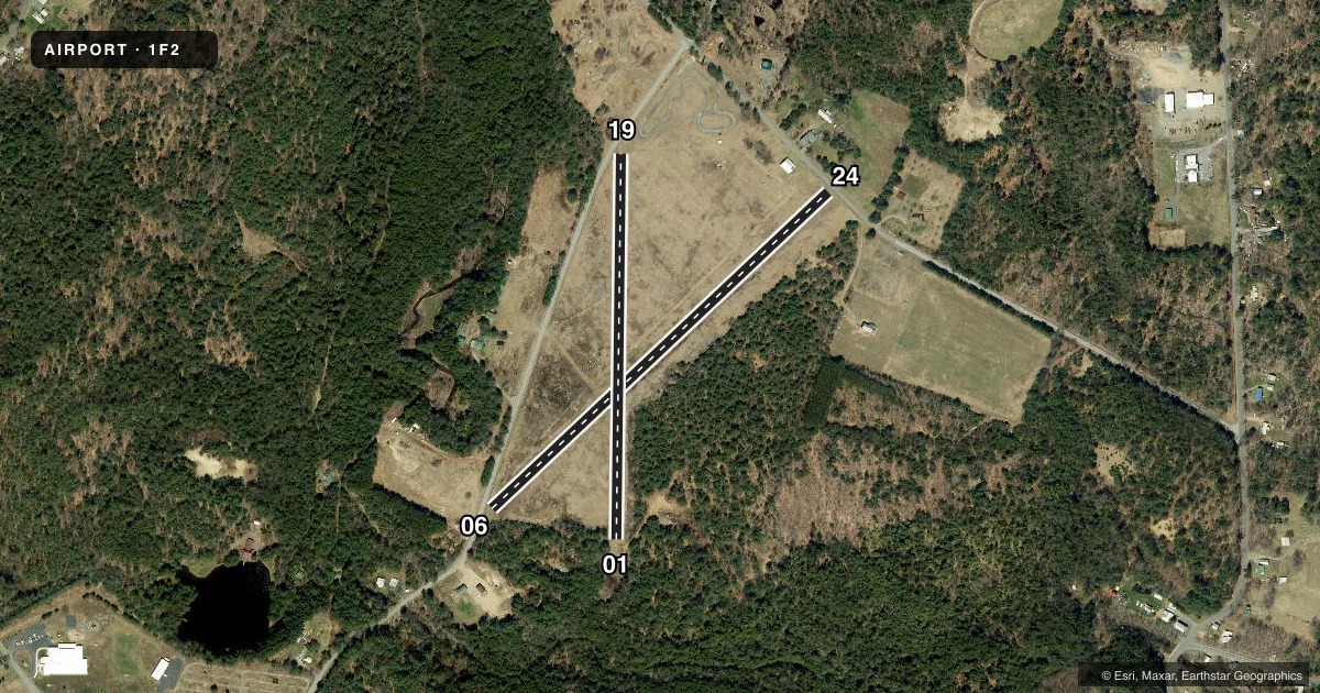
| 06/24 | 33° / 213° | 2,400 ft | TURF | Standard L |
| 01/19 | 347° / 167° | 2,000 ft | TURF | Standard L |
Runway end performance
| End | TORA | TODA | ASDA | LDA | VGSI | Approach lights | Obstruction |
|---|---|---|---|---|---|---|---|
| 06 | — | — | — | — | — | — | 63', road, 38' from thr, 100' R of cntrln, slope 0 |
| 24 | — | — | — | — | — | — | 48', road, 98' from thr, 61' R of cntrln, slope 2 |
| 01 | — | — | — | — | — | — | 54', trees, 89' from thr, 69' R of cntrln, slope 1 |
| 19 | — | — | — | — | — | — | 35', trees, 121' from thr, 44' R of cntrln, slope 3 |
Declared distances in feet. TORA = takeoff run available, TODA = takeoff distance, ASDA = accelerate-stop, LDA = landing distance.
Airport sketch
Runways drawn to scale from FAA survey coordinates, rendered over satellite imagery. Not for navigation.
Approaches & charts
Services on the field
Fuel grades, oxygen, maintenance, ramp storage and lighting — as declared to the FAA by the airport operator.
Fuel & services
- Fuel
- Not available
- Airframe repair
- Not available
- Power plant repair
- Not available
- Other services
- INSTR
Ramp & ground
- Transient storage
- Tie-down
- Landing fee
- No fee published
- Wind indicator
- Yes
- Segmented circle
- Yes
Fuel & FBOs
Cheapest 100LL and Jet A on the field and nearby. Always confirm with the FBO before taxi.
Airport notes
Surface conditions, obstructions, local procedures, lighting outages and other notes published with each FAA cycle.
General notes
- ULTRALGT ACFT ON & INVOF ARPT.
- ACFT PARKED/HANGARED ON NON ARPT LAND. CROSS PUBLIC ROAD TO/FM ARPT.
- RWY 24; +35 - 50 FT TREES, 90 - 250 FT FROM THLD, 0 - 125 FT R OF CNTRLN AND +50 FT TREES, 350 - 425 FT FROM THLD 110 - 150 FT L OF CNTRLN.
- RWY 19; +17 - 52 FT TREES, 0 - 230 FT FROM THLD, 50 - 100 FT R OF CNTRLN.
- RWY 1; +30 - 60 FT TREES, 0 - 240 FROM THLD, 15 - 100 FT L AND R OF CNTRLN.
- RWY 6; +20 - 65 FT TREES, 0 - 500 FT FROM THLD, 30 - 150 L AND R OF CNTRLN.
- FOR CD CTC ALBANY APCH AT 518-862-2299.
- ARPT NOT PLOWED OR MNTND DURG WINTER MONTHS; RWY SFC CAN BE SOFT AS FROST LEAVES THE GND IN SPRING.
- 4 FT GRAVEL PILE AT END OF RWY 01.
Runway surface & condition
- 01/19RWY WIDTH EDGE MARKED WITH RED CONES ALL SEASONS EXCEPT WINTER
- 06/24RWY WIDTH EDGE MARKED WITH RED CONES ALL SEASONS EXCEPT WINTER
Approach & departure obstructions
- 06CTLNG OBSTN EXCEEDS 45 DEG SLP.
- 01ROAD ON BOTH SIDES OF CTRLN RY 01.
- 06ROAD ON BOTH SIDES OF CTRLN AT AN ANGLE TO RY 06.
- 19ROAD ON BOTH SIDES OF CTRLN AT AN ANGLE TO RY 19.
- 24ROAD ON BOTH SIDES OF CTRLN RY 24.
Other notes
- ESTABD PRIOR TO 1959
VFR map & nearby airports
VFR sectional. Tap any ICAO chip to open that airport.
Key facts · 1F2
Answer card- ICAO
- 1F2
- Name
- PLATEAU SKY RANCH
- Location
- EDINBURG, NEW YORK
- Elevation
- 1,070 ft MSL
- Traffic pattern altitude
- 2,070 ft MSL (1,000 AGL)
- Control tower
- Non-towered (use CTAF)
- Total runways
- 2
- Longest runway
- 06/24 · 2,400 ft
- Published ILS approaches
- 0
- Published frequencies
- 2
- Magnetic variation
- 14°
- Current flight rules
- VFR
- Current wind
- 000° at 0 kt
- Favored runway now
- –
Plateau Sky Ranch is in Edinburg, New York. The field elevation is 1,070 ft MSL. It has two turf runways. The longest is 2,400 ft on 06/24. There is no control tower. CTAF and UNICOM are both 122.8. No ILS approaches are published here.
Pattern altitude is not published. Use 1,000 ft AGL for light piston planning unless the current FAA Chart Supplement or the airport operator says otherwise. With the field sitting above 1,000 ft MSL, expect a little more performance planning than at a lowland strip. The published remarks also call out ultralight activity on and near the airport. That means a careful scan on arrival and in the pattern is smart.
The airport has no on-field FBOs listed. Contact the airport operator directly before arrival, or call the field on CTAF or UNICOM for current fuel and service availability. Published remarks also note trees near both ends of runway 01/19, roads close to the runway centerlines and red cone edge markers on 01/19 and 06/24 except in winter. The field is not plowed or maintained in winter. Spring thaw can leave the turf soft. Check runway condition before you go.