METAR & TAF K09
K09 does not publish a METAR.
Showing the nearest reporting station: KGFL (FLOYD BENNETT MEML) · 40.0 NM away. Conditions at K09 may differ.
METAR · KGFL
Observed 10:53Z
KGFL 251053Z AUTO 00000KT 10SM CLR 14/12 A3017 RMK AO2 SLP214 T01390122
- Wind
- 000° @ 0 kt
- Visibility
- 10 SM
- Temp / Dew
- 14°C / 12°C
- Altimeter
- 30.17 inHg
- Clouds
- CLR
- Density alt
- 1,682 ft
- Ceiling
- Unlimited
- Rules
- VFR
Airport info & contacts
Manager on record, flight service, ARTCC, attendance schedule and pattern altitude — published by the FAA and refreshed every 28 days.
Location
- From city
- 1 NM N
- VFR sectional
- NEW YORK
- ARTCC
- ZBW · BOSTON
- NOTAM facility
- BUF (NOTAM-D)
Airport manager
- Name
- TOWN OF ARIETTA
- Phone
- 518-548-3415
- Address
- BOX 37, PISECO LAKE NY 12139
Flight service · Hours
- FSS BUF
- BUFFALO1-800-WX-BRIEF
- Attendance
- MAY-OCT · SAT-SUN · 0900-1700
Frequencies
Tap any row to copy the frequency to your clipboard.
Runways & pattern
Full pagePattern entry · RWY 04
RIGHT TRAFFICRunway end performance
| End | TORA | TODA | ASDA | LDA | VGSI | Approach lights | Obstruction |
|---|---|---|---|---|---|---|---|
| 04 | — | — | — | — | PAPI 2-box left(3.8°) | — | 52', trees, 450' from thr, 144' R of cntrln, slope 4 |
| 22 | — | — | — | — | — | — | 92', trees, 562' from thr, 201' R of cntrln, slope 3 |
Declared distances in feet. TORA = takeoff run available, TODA = takeoff distance, ASDA = accelerate-stop, LDA = landing distance.
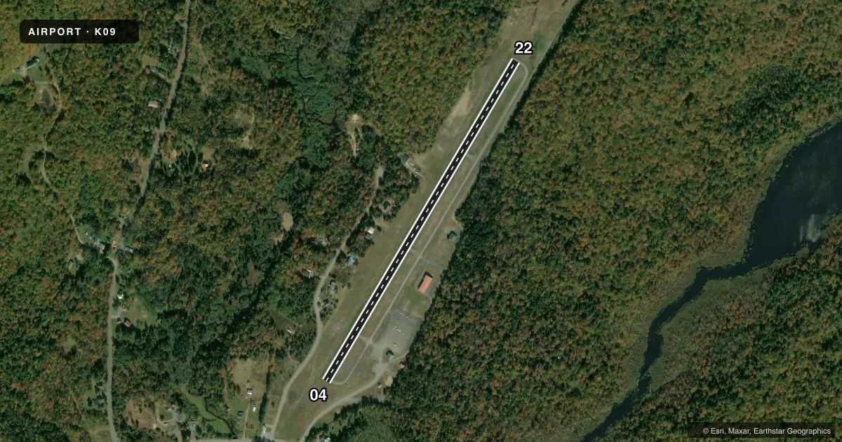
Airport sketch
Runways drawn to scale from FAA survey coordinates, rendered over satellite imagery. Not for navigation.
Approaches & charts
Services on the field
Fuel grades, oxygen, maintenance, ramp storage and lighting — as declared to the FAA by the airport operator.
Fuel & services
- Fuel
- 100LL
- Oxygen (bottled)
- Not available
- Oxygen (bulk)
- Not available
- Airframe repair
- Not available
- Power plant repair
- Not available
Ramp & ground
- Transient storage
- Tie-down
- Hangar
- Landing fee
- No fee published
- Customs
- Not available
- Lighting schedule
- SEE RMK
- Wind indicator
- Lighted
- Segmented circle
- Yes
Fuel & FBOs
Cheapest 100LL and Jet A on the field and nearby. Always confirm with the FBO before taxi.
Airport notes
Surface conditions, obstructions, local procedures, lighting outages and other notes published with each FAA cycle.
General notes
- CTN-MODERATE TURBULANCE IN APCH TO RWY 22.
- SEAGULLS - DEER - BEARS OCCASIONALLY VCNTY OF RWY DURING SUMMER MONTHS.
- ACFT DEPARTING RWY 22 ARE REQUESTED TO MAINTAIN RWY HEADING UNTIL PAST ISLAND CHECKPOINT, PRIOR TO MAKING LEFT TURN. ACFT ARRIVING MAINTAIN RGT DOWNWIND HEADING UNTIL PAST ISLAND CHECKPOINT.
- TWYS HAVE REFLECTIVE MARKERS.
- EXPECT TURBULENCE & DOWNDRAFTS DURG PERIODS OF STRONG CROSSWINDS.
- AREA NOT MAINTAINED FOR SKI EQUIPPED ACFT.
- RWY 04/22 MAY BE UNUSBL DUE TO SNOW ACCUMULATION NOV-APR. CHECK NOTAMS OR CALL 518-548-3415 FOR AIRFIELD CONDITIONS.
- FOR CD CTC SYRACUSE APCH AT 315-455-6218.
Lighting notes
- ACTVT REIL RWY 04 & 22; PAPI RWY 04; MIRL RWY 04/22; HELIPAD PERIMETER LGTS - CTAF. RWY LGTS (ELECTRIC EYE OVER-RIDE).
Approach & departure obstructions
- 04ROADS PARALLEL TO RWY 124 FT LT AND 215 FT RT.
- 22RWY 22 +80 FT TREES, 0-200 FT FROM RWY, 243 FT LT AND RT OF CENTERLINE.
- 04RWY 04 PAPI UNUSBL 9 DEG RIGHT OF CTRLN.
Other notes
- FILED FOR RECORD PURPOSES ONLY.
- MANAGERAFT HRS CALL 518-571-6066.
VFR map & nearby airports
VFR sectional. Tap any ICAO chip to open that airport.
Key facts · K09
Answer card- ICAO
- K09
- Name
- PISECO
- Location
- PISECO, NEW YORK
- Elevation
- 1,703.2 ft MSL
- Traffic pattern altitude
- 2,703.2 ft MSL (1,000 AGL)
- Control tower
- Non-towered (use CTAF)
- Total runways
- 1
- Longest runway
- 04/22 · 3,016 ft
- Published ILS approaches
- 0
- Published frequencies
- 2
- Magnetic variation
- 14°
- Current flight rules
- VFR
- Current wind
- 000° at 0 kt
- Favored runway now
- –
Piseco Airport sits in Piseco, New York at 1,703.2 ft MSL. It has one runway, 04/22, which is 3,016 ft long and asphalt. There is no control tower. CTAF and UNICOM are both 122.8. No ILS approaches are published here. The pattern altitude is not published, so use the standard 1,000 ft AGL for light piston operations unless the current Chart Supplement says otherwise.
Piseco Airport is on the field with AVGAS 100LL available. Call Piseco Airport at (518) 548-8794 for current service details. After hours, the manager can be reached at 518-571-6066. Published remarks call out runway lighting on both ends. There is a PAPI on runway 04. The PAPI on 04 is unusable 9 degrees right of centerline. Runway 22 has trees near the approach path. Moderate turbulence is noted on approach to runway 22. Strong crosswinds can bring turbulence and downdrafts. Wildlife is also a factor here, with seagulls, deer and bears reported near the runway in summer.
For departures and arrivals, pay close attention to the island checkpoint note. Aircraft departing runway 22 should hold runway heading until past the checkpoint before turning left. Arrivals should stay on right downwind heading until past the island checkpoint. Snow can make runway 04/22 unusable from November through April. Check NOTAMs or call ahead before you go.