METAR & TAF B04
B04 does not publish a METAR.
Showing the nearest reporting station: KGFL (FLOYD BENNETT MEML) · 16.5 NM away. Conditions at B04 may differ.
METAR · KGFL
Observed 11:53Z
KGFL 271153Z AUTO 00000KT 10SM CLR 20/16 A2984 RMK AO2 SLP105 T02000161 10200 20144 52008
- Wind
- 000° @ 0 kt
- Visibility
- 10 SM
- Temp / Dew
- 20°C / 16°C
- Altimeter
- 29.84 inHg
- Clouds
- CLR
- Density alt
- 823 ft
- Ceiling
- Unlimited
- Rules
- VFR
Airport info & contacts
Manager on record, flight service, ARTCC, attendance schedule and pattern altitude — published by the FAA and refreshed every 28 days.
Location
- From city
- 1 NM S
- VFR sectional
- NEW YORK
- ARTCC
- ZBW · BOSTON
- NOTAM facility
- BTV (NOTAM-D)
Airport manager
- Name
- MR. ZENE GARNSEY
- Phone
- 518-469-9472
- Address
- RFD 952 - ROUTE 4 SOUTH, SCHUYLERVILLE NY 12871
Flight service · Hours
- FSS BTV
- BURLINGTON1-800-WX-BRIEF
- Attendance
- MAY-SEP · DALGT
Frequencies
Tap any row to copy the frequency to your clipboard.
Runways & pattern
Full pagePattern entry · RWY 02
LEFT TRAFFICRunway end performance
| End | TORA | TODA | ASDA | LDA | VGSI | Approach lights | Obstruction |
|---|---|---|---|---|---|---|---|
| 02 | — | — | — | — | — | — | 80', road, 65' from thr, 105' R of cntrln, slope 1 |
| 20 | — | — | — | — | — | — | 68', road, 269' from thr, 43' R of cntrln, slope 3 |
Declared distances in feet. TORA = takeoff run available, TODA = takeoff distance, ASDA = accelerate-stop, LDA = landing distance.
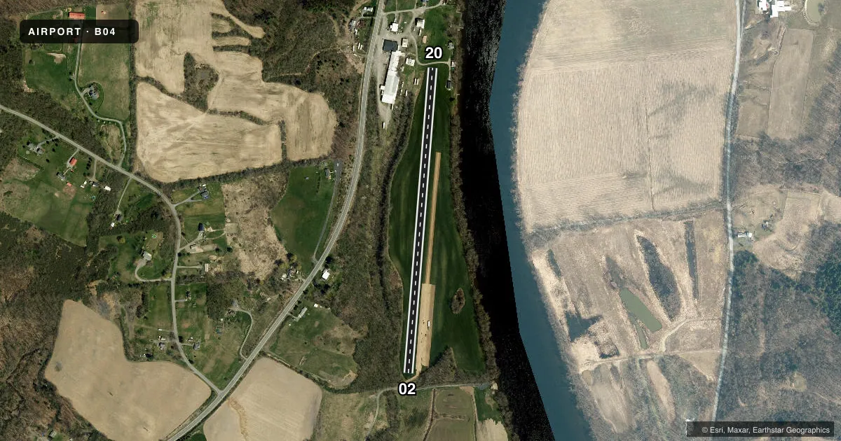
Airport sketch
Runways drawn to scale from FAA survey coordinates, rendered over satellite imagery. Not for navigation.
Approaches & charts
Services on the field
Fuel grades, oxygen, maintenance, ramp storage and lighting — as declared to the FAA by the airport operator.
Fuel & services
- Fuel
- Not available
- Airframe repair
- Not available
- Power plant repair
- Not available
Ramp & ground
- Transient storage
- Tie-down
- Landing fee
- No fee published
- Wind indicator
- Yes
- Segmented circle
- No
Fuel & FBOs
Cheapest 100LL and Jet A on the field and nearby. Always confirm with the FBO before taxi.
Airport notes
Surface conditions, obstructions, local procedures, lighting outages and other notes published with each FAA cycle.
General notes
- TURF STRIP MAY BE SOFT IN SPRING.
- ARPT OPEN DALGT HRS ONLY.
- NUMEROUS BLDGS IN APCH TO RY 20.
- TIEDOWNS LOCATED IMMED. NORTH OF DRIVEWAY ADJ TO RY 20 END.
- FOR CD CTC ALBANY APCH AT 518-862-2299.
Other notes
- EXISTED PRIOR TO 1959.
VFR map & nearby airports
VFR sectional. Tap any ICAO chip to open that airport.
Key facts · B04
Answer card- ICAO
- B04
- Name
- GARNSEYS
- Location
- SCHUYLERVILLE, NEW YORK
- Elevation
- 100 ft MSL
- Traffic pattern altitude
- 1,100 ft MSL (1,000 AGL)
- Control tower
- Non-towered (use CTAF)
- Total runways
- 1
- Longest runway
- 02/20 · 2,500 ft
- Published ILS approaches
- 0
- Published frequencies
- 1
- Magnetic variation
- 14°
- Current flight rules
- VFR
- Current wind
- 000° at 0 kt
- Favored runway now
- –
Garnseys (B04) sits in Schuylerville, New York. The field elevation is 100 ft MSL. It has one runway. Runway 02/20 is 2,500 ft of turf, so plan for grass performance and check field condition before you go. The airport is open during daylight hours only. The turf strip may be soft in spring. There are numerous buildings in the approach to runway 20, so that end deserves a careful look on arrival and departure.
There is no control tower. CTAF is 122.9. No ILS approaches are published. Pattern altitude is not published, so use the standard 1,000 ft AGL unless the current FAA Chart Supplement says otherwise. For clearance delivery, Albany Approach is listed at 518-862-2299. Tiedowns are located immediately north of the driveway next to the runway 20 end.
There are no on-field FBOs listed. If you need fuel or ramp details, contact the airport operator directly or call the field on CTAF for current availability. This is a small turf strip with limited published services, so first-time visitors should verify surface condition, daylight access and any local operating notes before launching.