METAR & TAF KDDH
Current METAR
Observed 14:54Z
KDDH 271454Z AUTO 00000KT 10SM SCT110 24/17 A2986 RMK AO2 SLP105 T02440172 57003
- Wind
- 000° @ 0 kt
- Visibility
- 10 SM
- Temp / Dew
- 24°C / 17°C
- Altimeter
- 29.86 inHg
- Clouds
- SCT
- Density alt
- 2,179 ft
- Ceiling
- Unlimited
- Rules
- VFR
Airport info & contacts
Manager on record, flight service, ARTCC, attendance schedule and pattern altitude — published by the FAA and refreshed every 28 days.
Location
- From city
- 3 NM W
- VFR sectional
- NEW YORK
- ARTCC
- ZBW · BOSTON
- NOTAM facility
- DDH (NOTAM-D)
Airport manager
- Name
- CHRIS BEITZEL
- Phone
- 802-272-7725
- Address
- 219 N MAIN ST, BARRE VT 05641
Flight service · Hours
- FSS BTV
- BURLINGTON1-800-WX-BRIEF
- Attendance
- MON-FRI · 0800-1600
- SAT-SUN · ON CALL
Frequencies
Tap any row to copy the frequency to your clipboard.
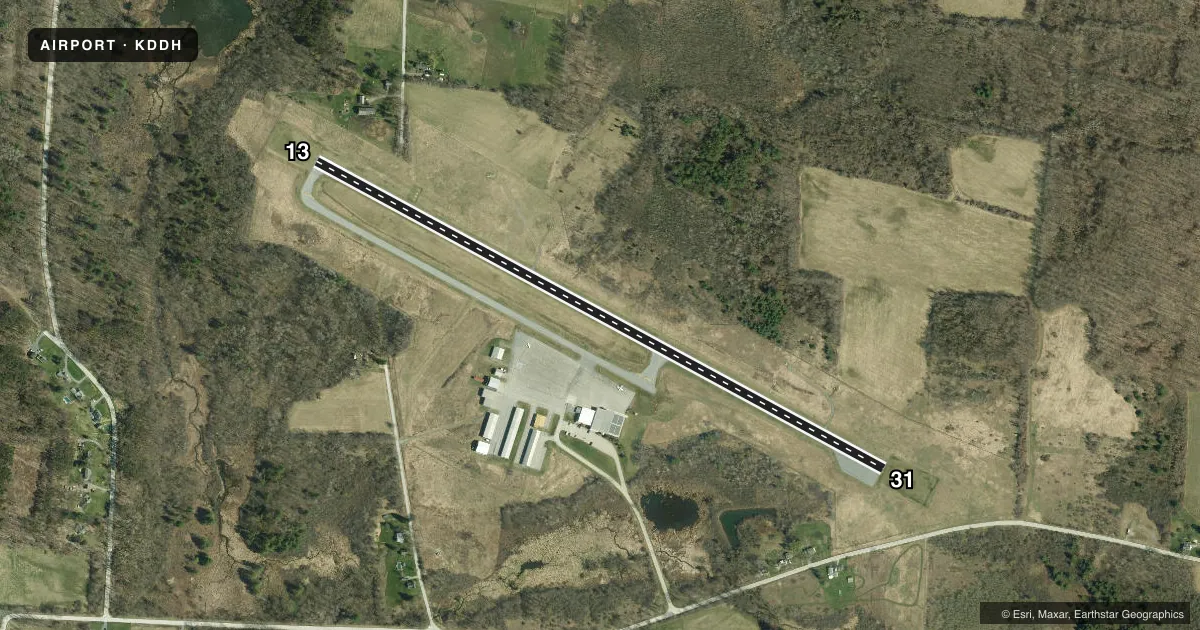
Runways & pattern
Full pagePattern entry · RWY 13
LEFT TRAFFICRunway end performance
| End | TORA | TODA | ASDA | LDA | VGSI | Approach lights | Obstruction |
|---|---|---|---|---|---|---|---|
| 13 | — | — | — | — | PAPI 4-box left(4°) | — | 170', hill, 3100' from thr, 425' R of cntrln, slope 17 |
| 31 | — | — | — | — | PAPI 4-box right(4°) | — | 40', gnd, 509' from thr, 178' R of cntrln, slope 7 |
Declared distances in feet. TORA = takeoff run available, TODA = takeoff distance, ASDA = accelerate-stop, LDA = landing distance.
Airport sketch
Runways drawn to scale from FAA survey coordinates, rendered over satellite imagery. Not for navigation.
Approaches & charts
Services on the field
Fuel grades, oxygen, maintenance, ramp storage and lighting — as declared to the FAA by the airport operator.
Fuel & services
- Fuel
- 100LLA
- Oxygen (bottled)
- High pressure
- Oxygen (bulk)
- Not available
- Airframe repair
- Major
- Power plant repair
- Major
- Other services
- AVNCS
Ramp & ground
- Transient storage
- Tie-down
- Hangar
- Landing fee
- No fee published
- Customs
- Not available
- Lighting schedule
- SEE RMK
- Beacon schedule
- SS-SR
- Beacon
- White / Green (civil land)(WG)
- Wind indicator
- Lighted
- Segmented circle
- Yes
Fuel & FBOs
Cheapest 100LL and Jet A on the field and nearby. Always confirm with the FBO before taxi.
Airport notes
Surface conditions, obstructions, local procedures, lighting outages and other notes published with each FAA cycle.
General notes
- RWY CONDS MAY NOT BE MNT OR RPRTD WHEN ARPT IS UNATNDD.
- NOISE ABATEMENT PROCS IN EFCT. AVOID FLT OVR HOMES SE OF ARPT. NOISE SENS AREA AER 31. RWY 13 IS PREFERRED USE RWY. IF PRACTICAL, DEP RWY 13 USING BEST ROC & WHEN ABV 400 FT AGL, TURN L WI 1 MI OF DER 13.
- BIRDS ON & INVOF ARPT.
- MTS ALL QUADS.
- TFC PAT OPS PROHIBITED S OF RWY 13 & RWY 31.
- COLD TEMPERATURE AIRPORT. ALTITUDE CORRECTION REQUIRED AT OR BELOW -12C.
- FOR CD CTC ALBANY APCH AT 518-862-2299.
Lighting notes
- ACTVT REIL RWY 13 & 31; PAPI RWY 13 & 31; MIRL RWY 13/31 - CTAF.
Fuel notes
- 100LL100LL SELF-SVC AVBL 24 HRS.
Approach & departure obstructions
- 3120 FT GND, 250 FT RIGHT OF CNTRLN.
- 1340 FT TREES, 540 FT, 128 FT L, APCH SLP 8:1.
Other notes
- EXISTED PRIOR TO 1959.
- 1FOR SVC CALL 802-442-5503; AFT HRS 888-649-5296.
VFR map & nearby airports
VFR sectional. Tap any ICAO chip to open that airport.
Key facts · KDDH
Answer card- ICAO
- KDDH
- Name
- WILLIAM H MORSE STATE
- Location
- BENNINGTON, VERMONT
- Elevation
- 826.6 ft MSL
- Traffic pattern altitude
- 1,826.6 ft MSL (1,000 AGL)
- Control tower
- Non-towered (use CTAF)
- Total runways
- 1
- Longest runway
- 13/31 · 3,704 ft
- Published ILS approaches
- 0
- Published frequencies
- 4
- Magnetic variation
- 14°
- Current flight rules
- VFR
- Current wind
- 000° at 0 kt
- Favored runway now
- –
William H Morse State is in Bennington, Vermont. The field elevation is 826.6 ft MSL. It has one runway. Runway 13/31 is 3,704 ft asphalt. There is no control tower. Traffic pattern altitude is not published, so use 1,000 ft AGL for light piston ops unless the current Chart Supplement says otherwise. No ILS approaches are published here.
Vermont Airport Services is on the field. It carries 100LL and Jet A. 100LL self-serve is available 24 hours. For service, call the FBO at (802) 442-5503. After hours, the published number is 888-649-5296.
This is a mountain airport. Mountains are in all quadrants. That matters on departure and arrival, especially with changing winds and density altitude. Noise abatement is published. Avoid flight over homes southeast of the airport. The noise-sensitive area is east of runway 31. Runway 13 is the preferred departure runway. If practical, depart runway 13 at best rate of climb. When above 400 ft AGL, turn left within 1 mile of the departure end. There is also a 20 ft ground obstruction 250 ft right of centerline near the runway 31 end. Birds are also reported on and near the airport. Runway lights, REILs and PAPI are on runway 13 and 31. The runway lights are controlled by CTAF.