METAR & TAF 5B7
5B7 does not publish a METAR.
Showing the nearest reporting station: KALB (ALBANY INTL) · 10.4 NM away. Conditions at 5B7 may differ.
METAR · KALB
Observed 16:51Z
KALB 231651Z 30008G15KT 10SM SCT055 24/10 A3013 RMK AO2 SLP202 T02390100 $
- Wind
- 300° @ 8G15 kt
- Visibility
- 10 SM
- Temp / Dew
- 24°C / 10°C
- Altimeter
- 30.13 inHg
- Clouds
- SCT
- Density alt
- 1,365 ft
- Ceiling
- Unlimited
- Rules
- VFR
Airport info & contacts
Manager on record, flight service, ARTCC, attendance schedule and pattern altitude — published by the FAA and refreshed every 28 days.
Location
- From city
- 6 NM SE
- VFR sectional
- NEW YORK
- ARTCC
- ZBW · BOSTON
- NOTAM facility
- BTV (NOTAM-D)
Airport manager
- Name
- GEORGE DUJACK, JR.
- Phone
- (518) 596-5947
- Address
- P.O. 304, POSTENKILL NY 12140
Flight service · Hours
- FSS BTV
- BURLINGTON1-800-WX-BRIEF
- Attendance
- Unattended
Frequencies
Tap any row to copy the frequency to your clipboard.
Runways & pattern
Full pagePattern entry · RWY 36
LEFT TRAFFICRunway end performance
| End | TORA | TODA | ASDA | LDA | VGSI | Approach lights | Obstruction |
|---|---|---|---|---|---|---|---|
| 18 | — | — | — | — | — | — | 53', trees, 349' from thr, 105' R of cntrln, slope 2 |
| 36 | — | — | — | — | — | — | 97', trees, 287' from thr, 90' R of cntrln, slope 0 |
Declared distances in feet. TORA = takeoff run available, TODA = takeoff distance, ASDA = accelerate-stop, LDA = landing distance.
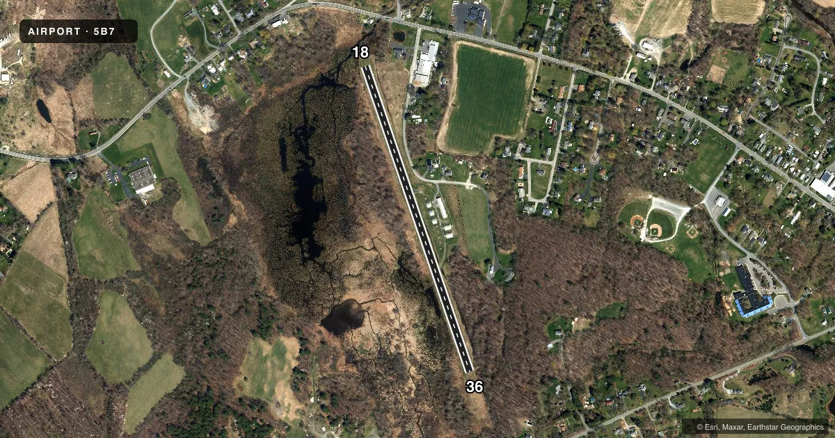
Airport sketch
Runways drawn to scale from FAA survey coordinates, rendered over satellite imagery. Not for navigation.
Approaches & charts
Services on the field
Fuel grades, oxygen, maintenance, ramp storage and lighting — as declared to the FAA by the airport operator.
Fuel & services
- Fuel
- Not available
Ramp & ground
- Transient storage
- Tie-down
- Landing fee
- No fee published
- Customs
- Not available
- Wind indicator
- Yes
- Segmented circle
- No
Fuel & FBOs
Cheapest 100LL and Jet A on the field and nearby. Always confirm with the FBO before taxi.
Airport notes
Surface conditions, obstructions, local procedures, lighting outages and other notes published with each FAA cycle.
General notes
- DEER & BIRDS ON & INVOF ARPT.
- SRNDG TRRN SLOPES DOWN TO RWY; DUE TO HIGHER SRNDG TRRN RCMD USE OF THE FLWG PROCS: DEP RWY 36 - USE BEST ANGLE OF CLIMB SPEED UNTIL WELL CLEAR OF RESIDENTIAL AREA N OF RWY 36;
- ARRS RWY 18 - MNTN SUF ALT ON FINAL SO AS TO AVOID LOW ALT AND/OR HIGH POWER OVER RESIDENTIAL AREA WHICH UNDERLIES FINAL APCH TO RWY 18. DEPS RWY 18 & ARRS RWY 36 - USE NORMAL PROCS.
- TSNT ACFT CALL (518) 596-5947 FOR FIELD CONDS PRIOR TO ARR.
- FOR CD CTC ALBANY APCH AT 518-862-2299.
Runway surface & condition
- 18/36RWY 18 FIRST 40 FT OVERGROWN WITH GRASS.
Approach & departure obstructions
- 1811FT TREE 153FT FM RWY END, 8FT L.
- 3618 FT TREE 164 FM RWY END, 35 FT R; 8 FT TREE 102 FT FM RWY END, 19 FT L.
- 36MARKING NRS FADED.
- 18RWY 18 MARKINGS NOT VSB.
- 18CTLNG OBSTN EXCEEDS 45 DEG SLP.
Other notes
- VFR ONLY
- 18/36WIDESPREAD SVR CRACKING AND DISTORTION. SVR SPALLING AND FAULTING. WIDESPREAD VEGETATION.
VFR map & nearby airports
VFR sectional. Tap any ICAO chip to open that airport.
Key facts · 5B7
Answer card- ICAO
- 5B7
- Name
- RENSSELAER COUNTY
- Location
- TROY, NEW YORK
- Elevation
- 440 ft MSL
- Traffic pattern altitude
- 1,440 ft MSL (1,000 AGL)
- Control tower
- Non-towered (use CTAF)
- Total runways
- 1
- Longest runway
- 18/36 · 2,670 ft
- Published ILS approaches
- 0
- Published frequencies
- 2
- Magnetic variation
- 14°
- Current flight rules
- VFR
- Current wind
- 300° at 8 kt
- Favored runway now
- RWY 36
Rensselaer County Airport is in Troy, New York. Field elevation is 440 ft MSL. The airport has one runway, 18/36, which is 2,670 ft long. There is no control tower. CTAF and UNICOM are both 122.7.
No ILS approaches are published here. Pattern altitude is not published, so use the standard 1,000 ft AGL for light piston operations unless the current Chart Supplement says otherwise. The field sits in terrain that slopes down to the runway. That matters on both ends. Depart runway 36 using best angle of climb speed until you are well clear of the residential area north of the runway. Arrivals to runway 18 should stay high enough on final to avoid low altitude and high power over the homes under the approach path. Departures from runway 18 and arrivals to runway 36 use normal procedures.
The airport is VFR only. Deer and birds are reported on and near the field. Runway 18 has an 11-foot tree close to the departure end. The first 40 ft of runway 18 is overgrown with grass. Markings on runway 18 are not visible. Markings on runway 36 are nearly faded. The runway surface also has severe cracking, distortion, spalling, faulting and vegetation. Transient aircraft should call the airport at (518) 596-5947 for field conditions before arrival. For clearance delivery, contact Albany Approach at 518-862-2299.