METAR & TAF KAQW
Current METAR
Observed 12:52Z
KAQW 271252Z AUTO 00000KT 10SM SCT110 18/13 A2987 RMK AO2 SLP113 T01830133
- Wind
- 000° @ 0 kt
- Visibility
- 10 SM
- Temp / Dew
- 18°C / 13°C
- Altimeter
- 29.87 inHg
- Clouds
- SCT
- Density alt
- 1,233 ft
- Ceiling
- Unlimited
- Rules
- VFR
Airport info & contacts
Manager on record, flight service, ARTCC, attendance schedule and pattern altitude — published by the FAA and refreshed every 28 days.
Location
- From city
- 3 NM W
- VFR sectional
- NEW YORK
- ARTCC
- ZBW · BOSTON
- NOTAM facility
- AQW (NOTAM-D)
Airport manager
- Name
- ANDREW FRANKLIN
- Phone
- 413-652-7735
- Address
- 10 MAIN ST - CITY HALL, NORTH ADAMS MA 01247
Flight service · Hours
- FSS BTV
- BURLINGTON1-800-WX-BRIEF
- Attendance
- IREG
Frequencies
Tap any row to copy the frequency to your clipboard.
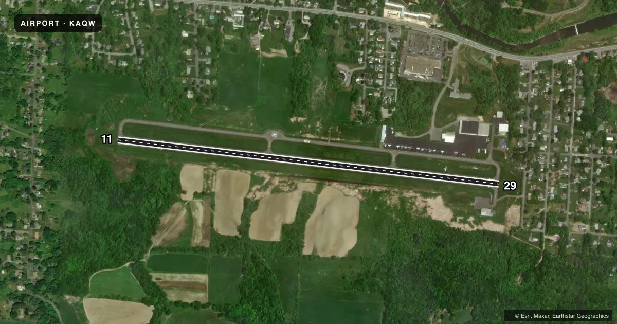
Runways & pattern
Full pagePattern entry · RWY 11
LEFT TRAFFICRunway end performance
| End | TORA | TODA | ASDA | LDA | VGSI | Approach lights | Obstruction |
|---|---|---|---|---|---|---|---|
| 11 | — | — | — | — | — | — | 62', trees, 920' from thr, 80' R of cntrln, slope 11 |
| 29 | — | — | — | — | — | — | 25', bldg, 340' from thr, 130' R of cntrln, slope 6 |
Declared distances in feet. TORA = takeoff run available, TODA = takeoff distance, ASDA = accelerate-stop, LDA = landing distance.
Airport sketch
Runways drawn to scale from FAA survey coordinates, rendered over satellite imagery. Not for navigation.
Approaches & charts
Services on the field
Fuel grades, oxygen, maintenance, ramp storage and lighting — as declared to the FAA by the airport operator.
Fuel & services
- Fuel
- 100LLA
- Oxygen (bottled)
- High pressure
- Airframe repair
- Major
- Power plant repair
- Major
- Other services
- AVNCS,GLD,RNTL,SURV,TOW
Ramp & ground
- Transient storage
- Tie-down
- Landing fee
- Yes
- Customs
- Not available
- Lighting schedule
- SEE RMK
- Beacon schedule
- SS-SR
- Beacon
- White / Green (civil land)(WG)
- Wind indicator
- Lighted
- Segmented circle
- No
Fuel & FBOs
Cheapest 100LL and Jet A on the field and nearby. Always confirm with the FBO before taxi.
Airport notes
Surface conditions, obstructions, local procedures, lighting outages and other notes published with each FAA cycle.
General notes
- MT RANGES 9100 FT N AT ELEV 1894 FT; 4300 FT N AT ELEV 2254 FT; 10800 FT S AT ELEV 2951 FT; 12800 FT S AT ELEV 2690 FT.
- EXTSV GLDR OPS DAWN-DUSK SFC-18000 FT YEAR ROUND; PRIMARILY WKENDS & HOLS.
- RWY 29 RIGHT TFC FOR PWRD ACFT. RWY 29 LEFT TFC FOR GLD AND TOW PLANE.
- WILDLIFE ON & INVOF ARPT.
- FOR CD CTC ALBANY APCH AT 518-862-2299.
- TWY A2 REMOVED.
- PILOTS LDG ON RWY 29 ARE ENCOURAGED TO AVOID LOW APCHS, IF SAFE TO DO SO, OVR THE RES NBRHD JUST E OF THE ARPT.
- RWY 11 LEFT TFC FOR PWRD ACFT. RWY 11 RIGHT TFC FOR GLD AND TOW PLANE.
Lighting notes
- ACTVT MIRL RWY 11/29 - CTAF.
Approach & departure obstructions
- 11APCH RATIO 20:1 TO DTHR.
- 29APCH RATIO 20:1 TO DTHR.
Other notes
- FILED FOR RECORD PURPOSES ONLY.
- CTC AMGR FOR LNDG FEES.
VFR map & nearby airports
VFR sectional. Tap any ICAO chip to open that airport.
Key facts · KAQW
Answer card- ICAO
- KAQW
- Name
- HARRIMAN-AND-WEST
- Location
- NORTH ADAMS, MASSACHUSETTS
- Elevation
- 653.8 ft MSL
- Traffic pattern altitude
- 1,653.8 ft MSL (1,000 AGL)
- Control tower
- Non-towered (use CTAF)
- Total runways
- 1
- Longest runway
- 11/29 · 4,300 ft
- Published ILS approaches
- 0
- Published frequencies
- 4
- Magnetic variation
- 14°
- Current flight rules
- VFR
- Current wind
- 000° at 0 kt
- Favored runway now
- –
Harriman-and-West is in North Adams, Massachusetts. Field elevation is 653.8 ft MSL. The airport has one runway. Runway 11/29 is 4,300 ft asphalt, which is the longest runway on the field. There is no control tower. Clearance delivery is handled through Albany Approach. The published frequencies are 132.825 and 307.2 for APCH/P DEP/P. CTAF and UNICOM are both on 122.8.
No ILS approaches are published here. Pattern altitude is not published, so use the standard 1,000 ft AGL for light piston aircraft unless the current FAA Chart Supplement says otherwise. The field has two on-field FBOs. Turboprop East carries Jet A Prist. North Adams carries 100LL. Contact them directly for current services before you go.
This is a glider-active airport. Published remarks say glider and tow-plane traffic use right traffic for runway 29 and runway 11. Powered aircraft use left traffic on runway 11 and right traffic on runway 29. The Chart Supplement also notes wildlife on and near the airport. Mountain terrain is close by in several directions. Runway 29 also has a displaced-threshold approach note, so plan your descent and final carefully. Medium intensity runway lights on 11/29 are activated by CTAF.