METAR & TAF 4V8
4V8 does not publish a METAR.
Showing the nearest reporting station: KDDH (WILLIAM H MORSE STATE) · 16.9 NM away. Conditions at 4V8 may differ.
METAR · KDDH
Observed 03:54Z
KDDH 270354Z AUTO 00000KT 10SM CLR 16/14 A2986 RMK AO2 SLP108 T01560144
- Wind
- 000° @ 0 kt
- Visibility
- 10 SM
- Temp / Dew
- 16°C / 14°C
- Altimeter
- 29.86 inHg
- Clouds
- CLR
- Density alt
- 2,616 ft
- Ceiling
- Unlimited
- Rules
- VFR
Airport info & contacts
Manager on record, flight service, ARTCC, attendance schedule and pattern altitude — published by the FAA and refreshed every 28 days.
Location
- From city
- 1 NM SW
- VFR sectional
- NEW YORK
- ARTCC
- ZBW · BOSTON
- NOTAM facility
- BTV (NOTAM-D)
Airport manager
- Name
- ALLISON KIMBALL
- Phone
- 281-788-8450
- Address
- P.O. BOX 1MANCHESTER CENTER VT 05255
Flight service · Hours
- FSS BTV
- BURLINGTON1-800-WX-BRIEF
- Attendance
- UNATTND
Frequencies
Tap any row to copy the frequency to your clipboard.
Runways & pattern
Full pagePattern entry · RWY 01
LEFT TRAFFICRunway end performance
| End | TORA | TODA | ASDA | LDA | VGSI | Approach lights | Obstruction |
|---|---|---|---|---|---|---|---|
| 01 | — | — | — | — | — | — | 6130', trees, 201' from thr, 103' R of cntrln, slope 0 |
| 19 | — | — | — | — | — | — | 50', trees, 201' from thr, 95' R of cntrln, slope 0 |
Declared distances in feet. TORA = takeoff run available, TODA = takeoff distance, ASDA = accelerate-stop, LDA = landing distance.
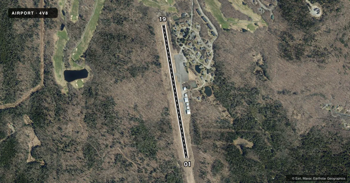
Airport sketch
Runways drawn to scale from FAA survey coordinates, rendered over satellite imagery. Not for navigation.
Approaches & charts
Services on the field
Fuel grades, oxygen, maintenance, ramp storage and lighting — as declared to the FAA by the airport operator.
Fuel & services
- Fuel
- Not available
Ramp & ground
- Transient storage
- Not published
- Landing fee
- Yes
- Segmented circle
- No
Fuel & FBOs
Cheapest 100LL and Jet A on the field and nearby. Always confirm with the FBO before taxi.
Airport notes
Surface conditions, obstructions, local procedures, lighting outages and other notes published with each FAA cycle.
General notes
- FOR CD CTC BOSTON ARTCC AT 603-879-6859.
- NO LN OF SIGHT BTN RWY ENDS.
- 60 FT DROP OFF, 60 FT FM RWY END.
- RWY 19: -60 FT DROP OFF, 60 FT FM RWY END.
Approach & departure obstructions
- 1918 FT TREE, 66 FT, 35 FT L.
- 01CTLG OBSTN EXCEEDS 45 DEG SLP.
Other notes
- THIS AIRPORT HAS BEEN SURVEYED BY THE NATIONAL GEODETIC SURVEY.
- NO OBJECTION.
- MANAGERARPT PHYS ADS: 69 AIRPORT RD, WEST DOVER, VT 05356.
- MANAGERLCL CTC LYNN BUCOSSI 802-681-3434.
- 01/19DEBRIS ON RWY, EXTSV CRACKING.
- 01/19DEBRIS ON RWY. EXTSV CRACKING.
VFR map & nearby airports
VFR sectional. Tap any ICAO chip to open that airport.
Key facts · 4V8
Answer card- ICAO
- 4V8
- Name
- DEERFIELD VALLEY RGNL
- Location
- WEST DOVER, VERMONT
- Elevation
- 1,953 ft MSL
- Traffic pattern altitude
- 2,953 ft MSL (1,000 AGL)
- Control tower
- Non-towered (use CTAF)
- Total runways
- 1
- Longest runway
- 01/19 · 2,650 ft
- Published ILS approaches
- 0
- Published frequencies
- 2
- Magnetic variation
- 15°
- Current flight rules
- VFR
- Current wind
- 000° at 0 kt
- Favored runway now
- –
Deerfield Valley Rgnl Airport (4V8) sits in West Dover, Vermont. Field elevation is 1,953 ft MSL. The airport has one runway. Runway 01/19 is 2,650 ft long with an asphalt surface. There is no control tower. CTAF and UNICOM are both 122.8.
No ILS approaches are published here. Pattern altitude is not published, so use 1,000 ft AGL for light piston traffic unless the current FAA Chart Supplement says otherwise. The field is high enough that density altitude can matter on warm days. Plan performance with that in mind.
Published remarks point to a few things a first-time pilot should know. There is debris on the runway and extensive cracking. There is also an obstruction issue near both ends. Runway 19 has a tree close to the departure end. Runway 01 has a cataloged obstruction that exceeds a 45-degree slope. There is a 60-foot drop off close to the runway end, so pay close attention to your rollout and takeoff planning. There is no line of sight between runway ends. For clearance delivery, contact Boston ARTCC at 603-879-6859. No on-field FBOs are listed, so verify services with the airport operator or call ahead before arrival.