METAR & TAF KVSF
Current METAR
Observed 14:54Z
KVSF 271454Z AUTO 00000KT 10SM CLR 24/15 A2986 RMK AO2 SLP108 T02440150 56007
- Wind
- 000° @ 0 kt
- Visibility
- 10 SM
- Temp / Dew
- 24°C / 15°C
- Altimeter
- 29.86 inHg
- Clouds
- CLR
- Density alt
- 1,871 ft
- Ceiling
- Unlimited
- Rules
- VFR
Airport info & contacts
Manager on record, flight service, ARTCC, attendance schedule and pattern altitude — published by the FAA and refreshed every 28 days.
Location
- From city
- 3 NM NW
- VFR sectional
- NEW YORK
- Pattern altitude
- 1,100 ft AGL · 1,678 ft MSL
- ARTCC
- ZBW · BOSTON
- NOTAM facility
- VSF (NOTAM-D)
Airport manager
- Name
- CHRIS BEITZEL
- Phone
- 802-272-7725
- Address
- 219 N MAIN ST, BARRE VT 05641
Flight service · Hours
- FSS BTV
- BURLINGTON1-800-WX-BRIEF
- Attendance
- 0800-1800
Frequencies
Tap any row to copy the frequency to your clipboard.
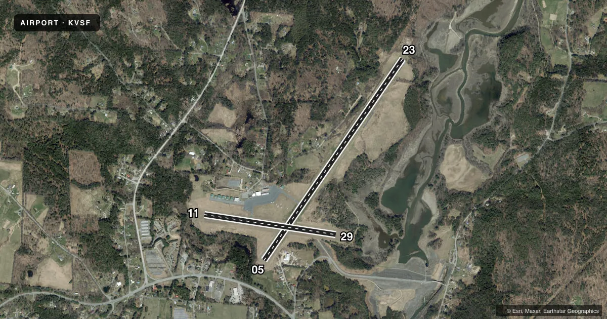
Runways & pattern
Full pagePattern entry · RWY 05
LEFT TRAFFIC| Runway | Heading (°M) | Length | Surface | Traffic |
|---|---|---|---|---|
| 05/23 | 20° / 200° | 5,501 ft | ASPH | Standard L |
| 11/29 | 84° / 264° | 3,000 ft | ASPH | Standard L |
Runway end performance
| End | TORA | TODA | ASDA | LDA | VGSI | Approach lights | Obstruction |
|---|---|---|---|---|---|---|---|
| 05 | — | — | — | — | VASI 4-box left(4°) | — | 50', trees, 201' from thr, 214' R of cntrln |
| 23 | — | — | — | — | — | — | 50', trees, 201' from thr, 250' R of cntrln |
| 11 | — | — | — | — | — | — | 70', trees, 290' from thr, 155' R of cntrln, slope 1 |
Declared distances in feet. TORA = takeoff run available, TODA = takeoff distance, ASDA = accelerate-stop, LDA = landing distance.
Airport sketch
Runways drawn to scale from FAA survey coordinates, rendered over satellite imagery. Not for navigation.
Approaches & charts
ILS · 1
Services on the field
Fuel grades, oxygen, maintenance, ramp storage and lighting — as declared to the FAA by the airport operator.
Fuel & services
- Fuel
- 100LLAA+
- Oxygen (bottled)
- Not available
- Oxygen (bulk)
- Not available
- Airframe repair
- Major
- Power plant repair
- Major
- Other services
- AFRT,AVNCS,CHTR,INSTR,RNTL,TOW
Ramp & ground
- Transient storage
- Tie-down
- Hangar
- Landing fee
- No fee published
- Customs
- Not available
- Lighting schedule
- SEE RMK
- Beacon schedule
- SS-SR
- Beacon
- White / Green (civil land)(WG)
- Wind indicator
- Lighted
- Segmented circle
- No
Fuel & FBOs
Cheapest 100LL and Jet A on the field and nearby. Always confirm with the FBO before taxi.
Airport notes
Surface conditions, obstructions, local procedures, lighting outages and other notes published with each FAA cycle.
General notes
- RWY CONDS NOT MNT WHEN ARPT IS UNATNDD.
- BIRDS ON & INVOF ARPT.
- APN & TWYS A & B ARE PCN S-46 & D-62.
- NOISE SENSITIVE AREA W OF ARPT.
- RWY 23 IS CALM WIND RWY IN DAY VFR CONDS.
- MNTN TPA ON DOWNWIND LEG FOR RWY 05.
- COLD TEMPERATURE AIRPORT. ALTITUDE CORRECTION REQUIRED AT OR BELOW -19C.
- FOR CD IF UNA TO CTC ON FSS FREQ, CTC BOSTON ARTCC AT 603-879-6859 .
Lighting notes
- ACTVT REIL RWY 05; MIRL RWY 05/23 & 11/29 - CTAF.
Fuel notes
- 100LLFULL & SELF SVC.
- A+FULL SVC ONLY.
Approach & departure obstructions
- 0535 FT TREES, 0-199 FT, 150-250 FT L.
- 2350 FT TREES, 0-200 FT, 135-250 FT L.
- 05CTLG OBSTN EXCEEDS 45 DEG SLP.
Other notes
- EXISTED PRIOR TO 1959.
- GLDRS ON & INVOF ARPT.
- 1100 FT AGL SNGL ENG; 1600 FT AGL MULT ENG.
- 1AFT HRS CALL 603-762-8080.
VFR map & nearby airports
VFR sectional. Tap any ICAO chip to open that airport.
Key facts · KVSF
Answer card- ICAO
- KVSF
- Name
- HARTNESS STATE (SPRINGFIELD)
- Location
- SPRINGFIELD, VERMONT
- Elevation
- 577.5 ft MSL
- Traffic pattern altitude
- 1,677.5 ft MSL (1,100 AGL)
- Control tower
- Non-towered (use CTAF)
- Total runways
- 2
- Longest runway
- 05/23 · 5,501 ft
- Published ILS approaches
- 1
- Published frequencies
- 2
- Magnetic variation
- 15°
- Current flight rules
- VFR
- Current wind
- 000° at 0 kt
- Favored runway now
- –
Hartness State Airport is in Springfield, Vermont. The field elevation is 577.5 ft MSL. It has two asphalt runways. The longest is runway 05/23 at 5,501 ft. This is an uncontrolled airport with CTAF and UNICOM both on 122.8. The airport has one ILS approach for runway 05. Pattern altitude is 1,100 ft AGL, which is 1,677.5 ft MSL for single-engine traffic. Multi-engine traffic uses 1,600 ft AGL. Springfield Aviation is on the field. It carries 100LL and Jet A. The published remarks call out full service only. They also note glider activity on and near the airport. Runway 23 is the calm wind runway in day VFR conditions. A noise sensitive area lies west of the airport. Runway 05 has a cataloged obstruction that exceeds a 45 degree slope. Runway end identifier lights are activated on runway 05. Medium intensity runway lights on both runways are activated by CTAF. If you are new to KVSF, plan for mixed traffic. Pay attention to the west side noise area. Check runway condition if the airport is unattended. The airport sits in the Springfield area of Vermont, so winter performance and local weather deserve a close look before departure.